FAA INFORMATION EFFECTIVE 18 APRIL 2024
Location
| FAA Identifier: | MCG |
| Lat/Long: | 62-57-10.0221N 155-36-25.3730W
62-57.167035N 155-36.422883W
62.9527839,-155.6070481
(estimated) |
| Elevation: | 342.7 ft. / 104.5 m (surveyed) |
| Variation: | 19E (2005) |
| Time zone: | UTC -8 (UTC -9 during Standard Time) |
| Zip code: | 99627 |
Airport Operations
| Airport use: | Open to the public |
| Activation date: | 08/1947 |
| Control tower: | no |
| ARTCC: | ANCHORAGE CENTER |
| FSS: | MCGRATH FLIGHT SERVICE STATION (on field) [907-524-3611] |
| Alternate FSS: | ENA KENAI FLIGHT SERVICE STATION [1-866-864-1737] |
| NOTAMs facility: | MCG (NOTAM-D service available) |
| Attendance: | MAY-SEPT MON-WED 0700-1730, OCT-APR MON-FRI 0800 - 1630, MAY-SEPT THURS 0700-1500 |
| Wind indicator: | lighted |
| Segmented circle: | yes |
| Lights: | ACTVT REIL RWY 16 & 34; VASI RWY 16 & 34; MIRL RWY 05/23 & 16/34 - CTAF. |
| Beacon: | white-green (lighted land airport)
Operates sunset to sunrise. |
Airport Communications
| CTAF: | 123.6 |
| WX ASOS: | 135.65 (907-524-3850) |
| WX AWOS-3 at TLJ (11 nm W): | PHONE 907-552-1106 |
- APCH/DEP SVC PRVDD BY ANCHORAGE ARTCC ON FREQS 128.1/353.8 (MC GRATH RCAG).
- COMMUNICATIONS PRVDD BY MCGRATH FSS ON FREQ 123.6 (CTAF).
Nearby radio navigation aids
| VOR radial/distance | | VOR name | | Freq | | Var |
|---|
| MCG at field | | MC GRATH VORTAC | | 115.50 | | 19E |
| NDB name | | Hdg/Dist | | Freq | | Var | | ID |
|---|
| TAKOTNA RIVER | | 269/1.4 | | 350 | | 16E | | VTR | ...- - .-. |
Airport Services
| Fuel available: | 100LL JET-A1+ |
| Parking: | hangars and tiedowns |
| Airframe service: | MINOR |
| Powerplant service: | MINOR |
Runway Information
Runway 16/34
| Dimensions: | 5936 x 100 ft. / 1809 x 30 m |
| Surface: | asphalt/grooved, in good condition |
| Weight bearing capacity: | | Single wheel: | 32.0 | | Double wheel: | 80.0 | | Double tandem: | 120.0 |
|
| Runway edge lights: | medium intensity |
| RUNWAY 16 | | RUNWAY 34 |
| Latitude: | 62-57.552080N | | 62-56.578350N |
| Longitude: | 155-36.317107W | | 155-36.276572W |
| Elevation: | 342.6 ft. | | 342.3 ft. |
| Traffic pattern: | left | | left |
| Runway heading: | 160 magnetic, 179 true | | 340 magnetic, 359 true |
| Displaced threshold: | 546 ft. | | 547 ft. |
| Declared distances: | TORA:5936 TODA:5936 ASDA:5389 LDA:4843 | | TORA:5936 TODA:5936 ASDA:5390 LDA:4843 |
| Markings: | nonprecision, in good condition | | nonprecision, in good condition |
| Visual slope indicator: | 4-box VASI on left (3.00 degrees glide path) | | 4-box VASI on left (3.00 degrees glide path) |
| Runway end identifier lights: | yes | | yes |
| Touchdown point: | yes, no lights | | yes, no lights |
| Instrument approach: | LOC/DME | | |
| Obstructions: | 51 ft. tree, 2260 ft. from runway, 350 ft. left and right of centerline, 44:1 slope to clear
TRAIL 7 FT BLW 170 FT BYD RWY. | | 53 ft. tree, 1305 ft. from runway, 200 ft. left and right of centerline, 24:1 slope to clear
ROAD 6 FT BLW 115 FT BYD RWY. |
Runway 5/23
| Dimensions: | 2000 x 60 ft. / 610 x 18 m |
| Surface: | gravel, in good condition |
| Runway edge lights: | medium intensity |
| RUNWAY 5 | | RUNWAY 23 |
| Latitude: | 62-57.406703N | | 62-57.531770N |
| Longitude: | 155-37.130195W | | 155-36.463775W |
| Elevation: | 342.7 ft. | | 342.5 ft. |
| Traffic pattern: | left | | left |
| Runway heading: | 049 magnetic, 068 true | | 229 magnetic, 248 true |
| Touchdown point: | yes, no lights | | yes, no lights |
| Obstructions: | 22 ft. brush, 200 ft. from runway, 110 ft. left of centerline, 9:1 slope to clear | | none |
Airport Ownership and Management from official FAA records
| Ownership: | Publicly-owned |
| Owner: | ALASKA DOT&PF CENTRAL REGION
PO BOX 196900
ANCHORAGE, AK 99519-6900
Phone 907-269-0749 |
| Manager: | STEFFEN STRICK
PO BOX 21
MCGRATH, AK 99627
Phone 907-524-3241 |
Airport Operational Statistics
| Aircraft based on the field: | | 23 | | Single engine airplanes: | | 23 |
| |  | |
| Aircraft operations: avg 30/day * | | 82% | air taxi | | 9% | transient general aviation | | 9% | local general aviation | | * for 12-month period ending 31 December 2021 | |
Additional Remarks
| - | APRON TSNT PRKG MKD BY GREEN CONES. |
| - | WX CAMERA AVBL ON INTERNET AT HTTPS://WEATHERCAMS.FAA.GOV/. |
| - | WX BLN FAC ON ARPT; SEE INSIDE BACK COVER FOR OPS DETAILS. |
| - | MAINT SVC AVBL MAY-SEPT MON-THURS 0700L-1730L; OCT-APR MON-FRI 0800L-1700; AFT HR - AMGR. |
| - | LOCK WHEELED TURNS NA. |
| - | COLD TEMPERATURE AIRPORT. ALTITUDE CORRECTION REQUIRED AT OR BELOW -46C. |
| - | WATER FOWL ON & INVOF ARPT SPRING-FALL; MOOSE INVOF ARPT. |
| - | ARPT SAND LRGR GRADATION THAN FAA RCMDD/SEE AC150/5200-30. |
| - | FUELSVC FEE AFT 1700 DAILY & ON SUNDAYS. |
| - | FIRE ATTACK OPS DURG SUMMER. |
| - | RWY COND UNMNT; RCMD VISUAL INSP BFR LNDG. |
| - | CLSD TO ACR GTR THAN 30 PAX SEATS. |
| - | PAEW ON RWY. |
Instrument Procedures
NOTE: All procedures below are presented as PDF files. If you need a reader for these files, you should download the free Adobe Reader.NOT FOR NAVIGATION. Please procure official charts for flight.
FAA instrument procedures published for use from 18 April 2024 at 0901Z to 16 May 2024 at 0900Z.
IAPs - Instrument Approach Procedures |
|---|
| RNAV (GPS) RWY 16 **CHANGED** | |
download (216KB) |
| LOC/DME RWY 16 | |
download (279KB) |
| VOR/DME-C | |
download (218KB) |
| NOTE: Special Alternate Minimums apply | |
download (150KB) |
| NOTE: Special Take-Off Minimums/Departure Procedures apply | |
download (408KB) |
Other nearby airports with instrument procedures:
PATL - Tatalina LRRS Airport (11 nm W)
PAFS - Nikolai Airport (34 nm E)
PASL - Sleetmute Airport (87 nm SW)
PACJ - Crooked Creek Airport (96 nm SW)
|
|

Road maps at:
MapQuest
Bing
Google
| Aerial photo |
|---|
WARNING: Photo may not be current or correct
 Photo by Vicki Eifert
Photo taken 20-Jun-2018
looking northwest.
Photo by Vicki Eifert
Photo taken 20-Jun-2018
looking northwest.
Do you have a better or more recent aerial photo of Mc Grath Airport that you would like to share? If so, please send us your photo.
|
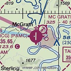
| Sectional chart |
|---|
|
| Airport distance calculator |
|---|
|
|
| Sunrise and sunset |
|---|
|
Times for 23-Apr-2024
| | Local
(UTC-8) | | Zulu
(UTC) |
|---|
| Morning civil twilight | | 05:28 | | 13:28 |
| Sunrise | | 06:26 | | 14:26 |
| Sunset | | 22:16 | | 06:16 |
| Evening civil twilight | | 23:13 | | 07:13 |
|
| Current date and time |
|---|
| Zulu (UTC) | 23-Apr-2024 10:29:56 |
|---|
| Local (UTC-8) | 23-Apr-2024 02:29:56 |
|---|
|
| METAR |
|---|
| PAMC | 230953Z AUTO 00000KT 10SM BKN095 M01/M04 A2998 RMK AO2 SLP158 T10061039 TSNO
|
PATL
10nm W | 230955Z AUTO 00000KT 10SM CLR 03/M04 A2999 RMK AO2 SLP164 T00331042
|
|
| TAF |
|---|
| PAMC | 230537Z 2306/2406 VRB06KT P6SM SCT040 BKN200
|
|
| NOTAMs |
|---|
NOTAMs are issued by the DoD/FAA and will open in a separate window not controlled by AirNav.
|
|

