FAA INFORMATION EFFECTIVE 18 APRIL 2024
Location
| FAA Identifier: | MI45 |
| Lat/Long: | 44-39-36.1646N 084-14-13.8750W
44-39.602743N 084-14.231250W
44.6600457,-84.2371875
(estimated) |
| Elevation: | 1051 ft. / 320.3 m (surveyed) |
| Variation: | 06W (1985) |
| From city: | 3 miles NE of LUZERNE, MI |
| Time zone: | UTC -4 (UTC -5 during Standard Time) |
| Zip code: | 48636 |
Airport Operations
| Airport use: | Private use. Permission required prior to landing |
| Activation date: | 08/1946 |
| Control tower: | no |
| ARTCC: | MINNEAPOLIS CENTER |
| FSS: | LANSING FLIGHT SERVICE STATION |
| Attendance: | UNATNDD |
| Wind indicator: | yes |
| Segmented circle: | no |
Airport Communications
Nearby radio navigation aids
| VOR radial/distance | | VOR name | | Freq | | Var |
|---|
| CGGr099/(21.0) | | GRAYLING VOR | | 109.80 | | 06W |
| GLRr143/29.0 | | GAYLORD VOR/DME | | 109.20 | | 06W |
| APNr236/38.5 | | ALPENA VORTAC | | 108.80 | | 07W |
| NDB name | | Hdg/Dist | | Freq | | Var | | ID |
|---|
| GRAYLING | | 108/25.8 | | 359 | | 06W | | GYG | --. -.-- --. |
Airport Services
Runway Information
Runway 18/36
| Dimensions: | 2600 x 100 ft. / 792 x 30 m |
| Surface: | turf, in good condition |
| Runway edge markings: | RWY & DTHR MKD WITH 3 FT YELLOW CONES. |
| RUNWAY 18 | | RUNWAY 36 |
| Latitude: | 44-39.794667N | | 44-39.366667N |
| Longitude: | 084-14.208333W | | 084-14.208333W |
| Elevation: | 1051.0 ft. | | 1051.0 ft. |
| Traffic pattern: | left | | left |
| Runway heading: | 186 magnetic, 180 true | | 006 magnetic, 000 true |
| Displaced threshold: | 440 ft. | | 715 ft. |
| Runway end identifier lights: | no | | no |
| Obstructions: | 45 ft. trees, 180 ft. from runway, 4:1 slope to clear
APCH RATIO 14:1 TO DTHR. | | 60 ft. trees, 120 ft. right of centerline
APCH RATIO 20:1 BASED ON STRAIGHT OUT OVR 60 FT TREES, 1220 FT DIST, 0 FT B. |
Runway 5/23
| Dimensions: | 2200 x 100 ft. / 671 x 30 m |
| Surface: | turf, in good condition |
| Runway edge markings: | RWY & DTHR MKD WITH 3 FT YELLOW CONES. |
| RUNWAY 5 | | RUNWAY 23 |
| Latitude: | 44-39.482667N | | 44-39.775000N |
| Longitude: | 084-14.408333W | | 084-14.108333W |
| Elevation: | 1051.0 ft. | | 1051.0 ft. |
| Traffic pattern: | left | | left |
| Runway heading: | 042 magnetic, 036 true | | 222 magnetic, 216 true |
| Displaced threshold: | 200 ft. | | 415 ft. |
| Runway end identifier lights: | no | | no |
| Obstructions: | 55 ft. trees, 770 ft. from runway, 115 ft. right of centerline, 14:1 slope to clear
APCH RATIO 20:1 TO DTHR. | | 40 ft. trees, 30 ft. from runway, 126 ft. left of centerline
APCH RATIO 12:1 TO DTHR OVR 47 FT TREE, 578 FT DIST, 130 FT L; 20:1 BASED ON STRAIGHT OUT. |
Airport Ownership and Management from official FAA records
| Ownership: | Publicly-owned |
| Owner: | US DEPT OF AGRICULTURE
107 MCKINLEY RD
MIO, MI 48647-9436
Phone 989-826-3252 |
| Manager: | CLIFF OLSON
3605 OAKVILLE WALTZ RD
NEW BOSTON, MI 48164-9669
Phone 734-775-1953 |
Airport Operational Statistics
| Aircraft based on the field: | | 1 | | Single engine airplanes: | | 1 |
| |  | |
| Aircraft operations: 150/year * | | 67% | transient general aviation | | 33% | local general aviation | | * for 12-month period ending 31 December 2015 | |
Additional Remarks
| - | ARPT CLSD NOV 14-APR 15 & WHEN SNOW COVD. |
| - | DEER ON & INVOF ARPT. |
| - | UAS OPR AT SOUTH END OF RWY 05/23. |
| - | FOR CD CTC MINNEAPOLIS ARTCC AT 651-463-5588. |
Instrument Procedures
There are no published instrument procedures at MI45.
Some nearby airports with instrument procedures:
KGOV - Grayling Army Airfield (21 nm W)
Y31 - West Branch Community Airport (25 nm S)
KHTL - Roscommon County/Blodgett Memorial Airport (26 nm SW)
KGLR - Gaylord Regional Airport (29 nm NW)
KOSC - Oscoda/Wurtsmith Airport (38 nm E)
|
|

Road maps at:
MapQuest
Bing
Google
| Aerial photo |
|---|
WARNING: Photo may not be current or correct

Do you have a better or more recent aerial photo of Lost Creek Airport that you would like to share? If so, please send us your photo.
|
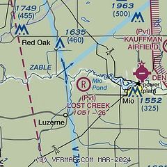
| Sectional chart |
|---|
|
| Airport distance calculator |
|---|
|
|
| Sunrise and sunset |
|---|
|
Times for 23-Apr-2024
| | Local
(UTC-4) | | Zulu
(UTC) |
|---|
| Morning civil twilight | | 06:07 | | 10:07 |
| Sunrise | | 06:39 | | 10:39 |
| Sunset | | 20:32 | | 00:32 |
| Evening civil twilight | | 21:03 | | 01:03 |
|
| Current date and time |
|---|
| Zulu (UTC) | 23-Apr-2024 09:54:47 |
|---|
| Local (UTC-4) | 23-Apr-2024 05:54:47 |
|---|
|
| METAR |
|---|
KGOV
21nm W | 230906Z AUTO 22008KT 10SM OVC060 08/07 A2967 RMK AO2 RAE06 SLP054 $
|
KY31
25nm S | 230935Z AUTO 20003KT 10SM OVC060 09/07 A2971 RMK AO2 T00910072
|
KHTL
26nm SW | 230853Z AUTO 19010G17KT 10SM OVC060 08/06 A2971 RMK AO2 RAE45 SLP062 P0001 60004 T00830056 58017
|
KGLR
29nm NW | 230853Z AUTO 19013KT 10SM OVC055 08/06 A2967 RMK AO2 RAE38 SLP046 P0004 60011 T00830061 58020
|
KAPN
38nm NE | 230854Z AUTO 20005KT 10SM -RA OVC055 09/04 A2972 RMK AO2 RAB00 SLP065 P0000 60000 T00940039 56010
|
KOSC
38nm E | 230935Z AUTO 20009KT 10SM -RA SCT043 BKN070 OVC085 09/05 A2974 RMK AO2 T00890046
|
KBFA
42nm NW | 230935Z AUTO 20011G18KT 10SM BKN060 OVC080 10/06 A2963 RMK AO2
|
|
| NOTAMs |
|---|
NOTAMs are issued by the DoD/FAA and will open in a separate window not controlled by AirNav.
|
|

