FAA INFORMATION EFFECTIVE 18 APRIL 2024
Location
| FAA Identifier: | MXA |
| Lat/Long: | 35-53-40.0100N 090-09-16.4540W
35-53.666833N 090-09.274233W
35.8944472,-90.1545706
(estimated) |
| Elevation: | 242.7 ft. / 74.0 m (surveyed) |
| Variation: | 01W (2015) |
| From city: | 2 miles NE of MANILA, AR |
| Time zone: | UTC -5 (UTC -6 during Standard Time) |
| Zip code: | 72442 |
Airport Operations
| Airport use: | Open to the public |
| Activation date: | 04/1944 |
| Control tower: | no |
| ARTCC: | MEMPHIS CENTER |
| FSS: | JONESBORO FLIGHT SERVICE STATION |
| NOTAMs facility: | JBR (NOTAM-D service available) |
| Attendance: | DAYLIGHT HOURS |
| Wind indicator: | lighted |
| Segmented circle: | yes |
| Lights: | ACTVT REIL RWYS 18 & 36; MIRL RWY 18/36; AND PAPI RWYS 18 & 36 - CTAF. LOCAL ARPT WX 4 CLICKS |
| Beacon: | white-green (lighted land airport)
Operates sunset to sunrise. |
Airport Communications
| CTAF/UNICOM: | 122.8 |
| WX ASOS at HKA (16 nm E): | 135.025 (870-763-8206) |
- 4 CLICKS FOR TEMP, WIND, AND DENSITY ALT.
- APCH/DEP SVC PRVDD BY MEMPHIS ARTCC ON FREQS 120.075/289.4 (WALNUT RIDGE RCAG).
Nearby radio navigation aids
| VOR radial/distance | | VOR name | | Freq | | Var |
|---|
| JBRr087/21.1 | | JONESBORO VOR/DME | | 115.85 | | 00W |
| GQEr022/36.4 | | GILMORE VOR/DME | | 113.00 | | 04E |
Airport Services
| Fuel available: | 100LL
100LL:FOR SVC AFT HRS CALL 901-605-1094 OUR 479-757-0722 NO FEE. FUEL AVBL WITH CREDIT CARD 8AM TO 5PM. |
| Parking: | tiedowns |
| Airframe service: | MAJOR |
| Powerplant service: | MAJOR |
| Bottled oxygen: | NONE |
| Bulk oxygen: | NONE |
Runway Information
Runway 18/36
| Dimensions: | 4201 x 75 ft. / 1280 x 23 m |
| Surface: | asphalt, in good condition |
| Weight bearing capacity: | |
| Runway edge lights: | medium intensity |
| RUNWAY 18 | | RUNWAY 36 |
| Latitude: | 35-54.013047N | | 35-53.320608N |
| Longitude: | 090-09.272153W | | 090-09.276307W |
| Elevation: | 240.8 ft. | | 242.7 ft. |
| Traffic pattern: | left | | right |
| Runway heading: | 181 magnetic, 180 true | | 001 magnetic, 000 true |
| Displaced threshold: | no | | 60 ft. |
| Markings: | nonprecision, in good condition | | nonprecision, in good condition |
| Visual slope indicator: | 2-light PAPI on right (4.00 degrees glide path) | | 2-light PAPI on left (4.00 degrees glide path) |
| Runway end identifier lights: | yes | | yes |
| Touchdown point: | yes, no lights | | yes, no lights |
| Obstructions: | 75 ft. tree, 2300 ft. from runway, 28:1 slope to clear | | 14 ft. road, 495 ft. from runway, 21:1 slope to clear
APCH SLOPE 34:1 TO DSPLCD THLD. |
Airport Ownership and Management from official FAA records
| Ownership: | Publicly-owned |
| Owner: | CITY OF MANILA
PO BOX 895
MANILA, AR 72442
Phone 870-561-4437 |
| Manager: | JOHN GEARHART
PO BOX 895
MANILA, AR 72442
Phone 479-757-0722 |
Airport Operational Statistics
| Aircraft based on the field: | | 23 | | Single engine airplanes: | | 20 | | Multi engine airplanes: | | 3 |
| |  | |
| Aircraft operations: avg 85/day * | | 96% | local general aviation | | 3% | transient general aviation | | <1% | military | | * for 12-month period ending 31 March 2019 | |
Additional Remarks
| - | NUMEROUS AGRICULTURAL ACFT OPNS FM FEB-NOV 500 FT AGL & BLO. |
| - | FOR CD CTC MEMPHIS ARTCC AT 901-368-8453/8449. |
Instrument Procedures
NOTE: All procedures below are presented as PDF files. If you need a reader for these files, you should download the free Adobe Reader.NOT FOR NAVIGATION. Please procure official charts for flight.
FAA instrument procedures published for use from 18 April 2024 at 0901Z to 16 May 2024 at 0900Z.
IAPs - Instrument Approach Procedures |
|---|
| RNAV (GPS) RWY 18 | |
download (182KB) |
| RNAV (GPS) RWY 36 | |
download (208KB) |
| NOTE: Special Take-Off Minimums/Departure Procedures apply | |
download (132KB) |
Other nearby airports with instrument procedures:
KBYH - Arkansas International Airport (11 nm E)
7M4 - Osceola Municipal Airport (14 nm SE)
KHKA - Blytheville Municipal Airport (16 nm E)
M12 - Steele Municipal Airport (19 nm NE)
KPGR - Kirk Field Airport (20 nm NW)
|
|

Road maps at:
MapQuest
Bing
Google
| Aerial photo |
|---|
WARNING: Photo may not be current or correct
 Photo courtesy of the Arkansas Department of Aeronautics
Taken in the Spring of 2007
Photo courtesy of the Arkansas Department of Aeronautics
Taken in the Spring of 2007
Do you have a better or more recent aerial photo of Manila Municipal Airport that you would like to share? If so, please send us your photo.
|
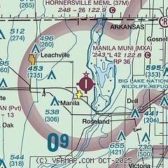
| Sectional chart |
|---|
|
| Airport distance calculator |
|---|
|
|
| Sunrise and sunset |
|---|
|
Times for 24-Apr-2024
| | Local
(UTC-5) | | Zulu
(UTC) |
|---|
| Morning civil twilight | | 05:49 | | 10:49 |
| Sunrise | | 06:16 | | 11:16 |
| Sunset | | 19:41 | | 00:41 |
| Evening civil twilight | | 20:08 | | 01:08 |
|
| Current date and time |
|---|
| Zulu (UTC) | 24-Apr-2024 17:20:44 |
|---|
| Local (UTC-5) | 24-Apr-2024 12:20:44 |
|---|
|
| METAR |
|---|
KHKA
16nm E | 241653Z AUTO 01009G17KT 10SM CLR 24/06 A3017 RMK AO2 SLP215 T02390056 $
|
KTKX
21nm N | 241655Z AUTO 04007G14KT 6SM HZ CLR 22/05 A3017 RMK AO2
|
KJBR
24nm W | 241653Z AUTO 03008KT 10SM CLR 23/06 A3019 RMK AO2 SLP220 T02280061 $
|
|
| TAF |
|---|
KJBR
24nm W | 241600Z 2416/2512 04010KT P6SM SKC FM250100 04004KT P6SM BKN250
|
|
| NOTAMs |
|---|
NOTAMs are issued by the DoD/FAA and will open in a separate window not controlled by AirNav.
|
|

