FAA INFORMATION EFFECTIVE 18 APRIL 2024
Location
| FAA Identifier: | MXO |
| Lat/Long: | 42-13-13.3030N 091-09-47.8740W
42-13.221717N 091-09.797900W
42.2203619,-91.1632983
(estimated) |
| Elevation: | 833.3 ft. / 254.0 m (surveyed) |
| Variation: | 01E (2000) |
| From city: | 2 miles SE of MONTICELLO, IA |
| Time zone: | UTC -5 (UTC -6 during Standard Time) |
| Zip code: | 52310 |
Airport Operations
| Airport use: | Open to the public |
| Activation date: | 10/1964 |
| Control tower: | no |
| ARTCC: | CHICAGO CENTER |
| FSS: | FORT DODGE FLIGHT SERVICE STATION |
| NOTAMs facility: | MXO (NOTAM-D service available) |
| Attendance: | 0730-1830
FOR SVC AFT HRS CALL 563-543-0503. UNATNDD ALL MAJOR HOLS. |
| Wind indicator: | lighted |
| Segmented circle: | no |
| Lights: | ACTVT MIRL RY 15/33; REIL AND PAPI RYS 15 & 33- CTAF. |
| Beacon: | white-green (lighted land airport)
Operates sunset to sunrise. |
Airport Communications
| CTAF/UNICOM: | 122.8 |
| WX AWOS-3: | 119.275 (319-465-6155) |
| CEDAR RAPIDS APPROACH: | 134.05 |
| CEDAR RAPIDS DEPARTURE: | 134.05 |
- APCH/DEP SVC PRVDD BY CHICAGO ARTCC ON FREQS 132.8/328.4 (CEDAR RAPIDS RCAG) WHEN CEDAR RAPIDS APCH CTL CLSD.
Nearby radio navigation aids
| VOR radial/distance | | VOR name | | Freq | | Var |
|---|
| DBQr238/22.9 | | DUBUQUE VORTAC | | 115.80 | | 04E |
| CIDr049/34.2 | | CEDAR RAPIDS VOR/DME | | 114.10 | | 05E |
Airport Services
| Fuel available: | 100LL JET-A
100LL:24 HR SELF SVC FUEL. |
| Parking: | hangars and tiedowns |
| Airframe service: | MAJOR |
| Powerplant service: | MAJOR |
| Bottled oxygen: | LOW |
| Bulk oxygen: | NONE |
Runway Information
Runway 15/33
| Dimensions: | 4400 x 75 ft. / 1341 x 23 m |
| Surface: | concrete, in good condition |
| Weight bearing capacity: | | PCN 6 /R/C/W/U | | Single wheel: | 12.5 |
|
| Runway edge lights: | medium intensity |
| RUNWAY 15 | | RUNWAY 33 |
| Latitude: | 42-13.591670N | | 42-12.941762N |
| Longitude: | 091-10.063783W | | 091-09.633250W |
| Elevation: | 825.7 ft. | | 829.8 ft. |
| Traffic pattern: | left | | left |
| Runway heading: | 153 magnetic, 154 true | | 333 magnetic, 334 true |
| Markings: | nonprecision, in good condition | | nonprecision, in good condition |
| Visual slope indicator: | 2-light PAPI on left (3.00 degrees glide path) | | 2-light PAPI on left (3.00 degrees glide path) |
| Runway end identifier lights: | yes | | yes |
| Touchdown point: | yes, no lights | | yes, no lights |
| Obstructions: | 61 ft. road, 1601 ft. from runway, 171 ft. right of centerline, 22:1 slope to clear | | 97 ft. trees, 3000 ft. from runway, 137 ft. right of centerline, 28:1 slope to clear |
Runway 9/27
| Dimensions: | 2300 x 90 ft. / 701 x 27 m |
| Surface: | turf, in fair condition |
| RUNWAY 9 | | RUNWAY 27 |
| Latitude: | 42-13.136160N | | 42-13.135098N |
| Longitude: | 091-09.955798W | | 091-09.446428W |
| Elevation: | 823.5 ft. | | 832.7 ft. |
| Traffic pattern: | left | | left |
| Runway heading: | 089 magnetic, 090 true | | 269 magnetic, 270 true |
| Markings: | NSTD, in fair condition | | NSTD, in fair condition |
| Touchdown point: | yes, no lights | | yes, no lights |
| Obstructions: | 23 ft. trees, 429 ft. from runway, 99 ft. right of centerline, 18:1 slope to clear | | 23 ft. road, 513 ft. from runway, 22:1 slope to clear |
Airport Ownership and Management from official FAA records
| Ownership: | Publicly-owned |
| Owner: | CITY OF MONTICELLO
102 W. 1ST ST.
MONTICELLO, IA 52310
Phone 319-465-3526 |
| Manager: | BRIAN OSTWINKLE...FBO
BOX 168 20373 HWY 38 S
MONTICELLO, IA 52310
Phone 319-465-5488
HOME PHONE 563-543-0503 |
Airport Operational Statistics
| Aircraft based on the field: | | 31 | | Single engine airplanes: | | 25 | | Multi engine airplanes: | | 5 | | Jet airplanes: | | 1 |
| |  | |
| Aircraft operations: avg 34/day * | | 48% | local general aviation | | 45% | transient general aviation | | 6% | air taxi | | * for 12-month period ending 07 June 2022 | |
Additional Remarks
| - | RY 33 IS CALM WIND RY. |
| - | FOR CD CTC CHICAGO ARTCC AT 630-906-8921. |
Instrument Procedures
NOTE: All procedures below are presented as PDF files. If you need a reader for these files, you should download the free Adobe Reader.NOT FOR NAVIGATION. Please procure official charts for flight.
FAA instrument procedures published for use from 18 April 2024 at 0901Z to 16 May 2024 at 0900Z.
IAPs - Instrument Approach Procedures |
|---|
| RNAV (GPS) RWY 15 | |
download (223KB) |
| RNAV (GPS) RWY 33 | |
download (234KB) |
| NOTE: Special Alternate Minimums apply | |
download (24KB) |
| NOTE: Special Take-Off Minimums/Departure Procedures apply | |
download (429KB) |
Other nearby airports with instrument procedures:
C17 - Marion Airport (20 nm SW)
KOQW - Maquoketa Municipal Airport (21 nm SE)
KDBQ - Dubuque Regional Airport (23 nm NE)
8C4 - Mathews Memorial Airport (27 nm S)
KCID - The Eastern Iowa Airport (32 nm SW)
|
|

Road maps at:
MapQuest
Bing
Google
| Aerial photo |
|---|
WARNING: Photo may not be current or correct
 Photo by Ray Fey
Photo taken 29-Apr-2011
looking south.
Photo by Ray Fey
Photo taken 29-Apr-2011
looking south.
Do you have a better or more recent aerial photo of Monticello Regional Airport that you would like to share? If so, please send us your photo.
|
| Sectional chart |
|---|
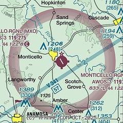
|
| Airport distance calculator |
|---|
|
|
| Sunrise and sunset |
|---|
|
Times for 19-Apr-2024
| | Local
(UTC-5) | | Zulu
(UTC) |
|---|
| Morning civil twilight | | 05:47 | | 10:47 |
| Sunrise | | 06:17 | | 11:17 |
| Sunset | | 19:50 | | 00:50 |
| Evening civil twilight | | 20:20 | | 01:20 |
|
| Current date and time |
|---|
| Zulu (UTC) | 19-Apr-2024 19:01:20 |
|---|
| Local (UTC-5) | 19-Apr-2024 14:01:20 |
|---|
|
| METAR |
|---|
| KMXO | 191835Z AUTO 28023G33KT 10SM CLR 12/M03 A3014 RMK AO2
|
|
| TAF |
|---|
KDBQ
23nm NE | 191720Z 1918/2018 27012G20KT P6SM FEW200 FM191900 28015G26KT P6SM SCT200 FM200000 29009KT P6SM FEW250 FM201500 31015KT P6SM SCT080
|
|
| NOTAMs |
|---|
NOTAMs are issued by the DoD/FAA and will open in a separate window not controlled by AirNav.
|
|

