FAA INFORMATION EFFECTIVE 18 APRIL 2024
Location
| FAA Identifier: | NKX |
| Lat/Long: | 32-52-06.7043N 117-08-35.4782W
32-52.111738N 117-08.591303W
32.8685290,-117.1431884
(estimated) |
| Elevation: | 477.1 ft. / 145.4 m (surveyed) |
| Variation: | 12E (2015) |
| From city: | 3 miles N of SAN DIEGO, CA |
| Time zone: | UTC -7 (UTC -8 during Standard Time) |
| Zip code: | 92126 |
Airport Operations
| Airport use: | Private use. Permission required prior to landing |
| Activation date: | 02/1944 |
| Control tower: | yes |
| ARTCC: | LOS ANGELES CENTER |
| FSS: | SAN DIEGO FLIGHT SERVICE STATION |
| NOTAMs facility: | NKX (NOTAM-D service available) |
| Attendance: | FRI 1630-0200Z++, ALL SAT CLSD, ALL SUN 2200-0200Z++, ALL HOL CLSD, ALL MON-THU 1530-0800Z |
| Segmented circle: | no |
| Lights: | ACTIVATE-ALSF-1, HIRL, CL AND PAPI RWY 06L-24R-298.925 OR 135.2 |
| Beacon: | white-white-green (lighted military airport)
Operates sunset to sunrise. |
Airport Communications
| ATIS: | 133.475 352.0 |
| MIRAMAR GROUND: | 128.625 307.325 [1530-0800Z MON-THU; 1630-0200Z++ FRI; CLSD SAT; 2200-0200Z++SUN. FLD CLSD NATL HOLS.] |
| MIRAMAR TOWER: | 135.2 298.925 340.2 [1530-0800Z MON-THU; 1630-0200Z++ FRI; CLSD SAT; 2200-0200Z++SUN. FLD CLSD NATL HOLS.] |
| SOCAL APPROACH: | 132.2 |
| SOCAL DEPARTURE: | 119.6 ;WEST 132.2 ;EAST |
| CLEARANCE DELIVERY: | 125.975 254.325 |
| CLASS B: | 132.2 ;029-061 SAN 14,000 FT & BLW 132.2 ;333-028 SAN 7,000 FT-11,000 F |
| PMSV METRO: | 342.4 |
| PTD: | 335.625 |
| WX ASOS at MYF (3 nm S): | 126.9 (858-576-4337) |
| WX ASOS at SAN (8 nm S): | PHONE 619-296-8934 |
| WX AWOS-3P at SEE (9 nm E): | 125.45 (619-449-1228) |
| WX ASOS at RNM (15 nm NE): | PHONE 760-789-7699 |
| WX ASOS at CRQ (17 nm NW): | PHONE 760-930-0864 |
| WX ASOS at NRS (18 nm S): | PHONE 619-437-9890 |
| WX ASOS at SDM (20 nm SE): | 132.35 (619-661-8297) |
Nearby radio navigation aids
| VOR radial/distance | | VOR name | | Freq | | Var |
|---|
| MZBr024/6.6 | | MISSION BAY VORTAC | | 117.80 | | 15E |
| PGYr318/17.6 | | POGGI VORTAC | | 116.45 | | 14E |
| TIJr322/21.9 | | TIJUANA VOR/DME | | 116.50 | | 12E |
| OCNr133/26.3 | | OCEANSIDE VORTAC | | 115.30 | | 15E |
| JLIr225/32.4 | | JULIAN VORTAC | | 114.00 | | 15E |
Airport Services
| Airframe service: | NONE |
| Powerplant service: | NONE |
| Bottled oxygen: | NONE |
| Bulk oxygen: | NONE |
Runway Information
Runway 6L/24R
| Dimensions: | 12000 x 200 ft. / 3658 x 61 m |
| Surface: | concrete |
| Weight bearing capacity: | |
| Runway edge lights: | high intensity |
| RUNWAY 6L | | RUNWAY 24R |
| Latitude: | 32-51.873985N | | 32-52.372448N |
| Longitude: | 117-09.890945W | | 117-07.621707W |
| Elevation: | 425.7 ft. | | 474.9 ft. |
| Traffic pattern: | left | | left |
| Runway heading: | 063 magnetic, 075 true | | 243 magnetic, 255 true |
| Visual slope indicator: | 4-light PAPI on left (3.00 degrees glide path) | | 4-light PAPI on left (3.00 degrees glide path) |
| Approach lights: | OLS | | ALSF1: standard 2,400 foot high intensity approach lighting system with centerline sequenced flashers (category I)
SF, OLS |
| Centerline lights: | yes | | yes |
| Touchdown point: | yes, no lights | | yes, no lights |
| Instrument approach: | | | ILS/DME |
Runway 6R/24L
| Dimensions: | 8001 x 200 ft. / 2439 x 61 m |
| Surface: | PEM |
| Weight bearing capacity: | |
| Runway edge lights: | high intensity |
| RUNWAY 6R | | RUNWAY 24L |
| Latitude: | 32-51.928375N | | 32-52.260677N |
| Longitude: | 117-09.100330W | | 117-07.587280W |
| Elevation: | 430.2 ft. | | 477.1 ft. |
| Traffic pattern: | left | | left |
| Runway heading: | 063 magnetic, 075 true | | 243 magnetic, 255 true |
| Visual slope indicator: | 4-light PAPI on left (3.00 degrees glide path) | | 4-light PAPI on left (3.00 degrees glide path) |
| Approach lights: | OLS | | OLS |
| Touchdown point: | yes, no lights | | yes, no lights |
Airport Ownership and Management from official FAA records
| Ownership: | U.S. Navy |
| Owner: | US NAVY
OCEANOGRAPHIC OFC - CODE 3142
WASHINGTON, DC 20373 |
| Manager: | COMMANDING OFFICER
MARINE CORPS AIR STATION MIRAMAR
SAN DIEGO, CA 92145 |
Additional Remarks
| E60-24R | HOOK E28(B) (2300') |
| E60-06R | HOOK E28(B) (1052') |
| E60-06L | HOOK E28(B) (2490') |
| E60-24L | HOOK E28(B) (2301') |
| - | CAUTION: WATER ON THE RUBBER BUILD-UP AREAS OF THE RWY MAY PRODUCE POOR TRACTION AND/OR BA AND STANDING WATER ON RWY MAY PRODUCE HYDROPLANING COND. |
| - | NS ABTMT: STRICTLY ENFORCED, MANDATORY PRO AND CRS RULES. ALL TRAN ACFT MUST REVIEW AND SIGN NOISE ABATEMENT FORM WITH FLT PLANNING. |
| - | CAUTION: HIGH MID-AIR POTENTIAL, EXER EXTREME VIGILANCE. |
| - | CAUTION: ALL ACFT ARR/DEP VFR VIA CORRIDOR RULES TO/FR COASTLINE ARE ADZD TO EXER EXTREME CTN TO AVOID HANG GLDR ACT NEAR TORRY PINES GOLF CRS, NKX R-283/5 DME. |
| - | CAUTION: EXTSV GEN AVIATION TFC ALL ALTS, ALL DRCT NEAR AFLD. HIGH VOLUME OF CIV VFR TFC ALONG THE COAST W OF AFLD. |
| - | MISC: ORDNANCE, LIVE OR INERT, NOT PMTD TO RMN ON RON TSNT ACFT. |
| - | SERVICE-LGT: PAPI RRP NOT COINCIDENTAL WITH PAR RY 24L & RY 24R. PAPI UNITS FOR RY 06R/L ARE OPTIMIZED FOR HGT GROUP 2 TYPE ACFT. |
| - | A-GEAR: SHORT FLD A-GEAR RWY 24R NML DE-RIGGED. |
| - | FUEL: J5 |
| - | FLUID: SP LHOX LOX. |
| - | OIL: O-148-156. |
| - | TRAN ALERT: NO AMC FLEET SVC AVBL. ALCE TEAM RQR FOR ALL AMC FLT. LTD TRAN SVC, NO TIE-DOWN, OIL/LABORATORY ANALYSIS OR TRAN MAINT SVC AVBL. |
| - | JASU: (A/M47A-4) (NC-10A1) (NC-10C) |
| - | TRAN ALERT: NO SHUTTLE SVC AVBL. ALL VIP ACFT CTC AIRFIELD OPS ON PTD 15 MIN PRIOR TO ARR. |
| - | RSTD (1 OF 3): PPR FOR ALL TSNT ACFT AND TRANSCOM/JOSAC/NALO ARE RQRD TO CTC VISITING ACFT LINE DSN 307-4284, C858-307-4284 (PPR RSTRD TO 30 MIN BFR/AFT APVD TIME; PPR NOT VALID OUTSIDE OF THIS WINDOW AND MUST BE RE-COORDD TO ARR). |
| - | RSTD (2 OF 3): FOR STAGING (LCL TRNG FLT) OR HIGH VISIBILITY EVENTS (VIP M7 AND ABOVE, MEDEVAC W/BATTLE PATIENTS, OIF/OEF HOMECOMING, HR/ANGEL FLIGHTS ETC.) ARE REQUIRED TO NOTIFY AIROPS 1HR PRIOR TO ARRIVAL DUE TO 3DMAW CG AND STATION CO COORDINATION. |
| - | RSTD (3 OF 3): PLEASE CTC THE OPS DUTY OFFICER AT DSN 307-4277/4284, C858-307-4277/4284. |
| - | TFC PAT: REDUCED RWY SEPARATION STD IN EFF USN/USMC ACFT. OPR ON PARL RWY 700' APART. MULTI PRACTICE APCH RY 06L/R NOT AUTH. RADAR VECTORS TO FINAL APCH EXP STEEP DESCENT. |
| - | AIRFIELD OPRG HRS ARE SUBJECT TO CHANGE; CHECK NOTAMS OR CTC AIRFIELD OPERATIONS TO VERIFY HRS. PILOTS FILING MCAS MIRAMAR AS AN ALTN OR EMERG DIVERT ARE ADVISED TO CALL AIRFIELD OPERATIONS TO VERIFY OPRG HRS. |
| - | CLOSED FIELD OPNS (CFO) ARE RSTRD AND RQR PPR. |
| - | FOR CD WHEN ATCT CLSD CTC SOCAL APCH AT 800-448-3724. |
| - | TFC PAT: GEN AVN ACFT AUTH TO CONDUCT PAR APCH SUN. APCH SHALL BE IN VFR CONDS TO A LOW APCH ONLY. ACFT NOT AUTH TO LAND FOR SCV EXC IN CASE OF EMERG. |
Instrument Procedures
NOTE: All procedures below are presented as PDF files. If you need a reader for these files, you should download the free Adobe Reader.NOT FOR NAVIGATION. Please procure official charts for flight.
FAA instrument procedures published for use from 18 April 2024 at 0901Z to 16 May 2024 at 0900Z.
IAPs - Instrument Approach Procedures |
|---|
| ILS Y OR LOC/DME Y RWY 24R | |
download (151KB) |
| ILS Z OR LOC/DME Z RWY 24R | |
download (153KB) |
| RNAV (GPS) RWY 24L | |
download (191KB) |
| RNAV (GPS) RWY 24R | |
download (214KB) |
| HI-TACAN Z RWY 24R | |
download (381KB) |
| TACAN Y RWY 24R | |
download (221KB) |
| Radar Approach Procedures available | |
download (165KB) |
Departure Procedures |
|---|
| LAKEE THREE | |
2 pages:
[1] [2] (203KB) |
| REDIN FOUR | |
download (93KB) |
| SWOLF NINE | |
2 pages:
[1] [2] (169KB) |
| TINNY FOUR | |
2 pages:
[1] [2] (155KB) |
| VITKO THREE | |
2 pages:
[1] [2] (230KB) |
| NOTE: Special Take-Off Minimums/Departure Procedures apply | |
download (236KB) |
Other nearby airports with instrument procedures:
KMYF - Montgomery-Gibbs Executive Airport (3 nm S)
KSAN - San Diego International Airport (8 nm S)
KSEE - Gillespie Field Airport (9 nm E)
KNZY - North Island Naval Air Station (Halsey Field) Airport (11 nm S)
KRNM - Ramona Airport (15 nm NE)
KCRQ - Mc Clellan-Palomar Airport (17 nm NW)
KNRS - Imperial Beach Naval Outlying Field (Ream Field) (18 nm S)
KSDM - Brown Field Municipal Airport (20 nm SE)
|
|

Road maps at:
MapQuest
Bing
Google
| Aerial photo |
|---|
WARNING: Photo may not be current or correct
 Photo courtesy of AirNav, LLC
Photo taken 11-May-2013
looking northeast from 7,000 ft.
Photo courtesy of AirNav, LLC
Photo taken 11-May-2013
looking northeast from 7,000 ft.
Do you have a better or more recent aerial photo of Miramar MCAS (Joe Foss Field) Airport that you would like to share? If so, please send us your photo.
|
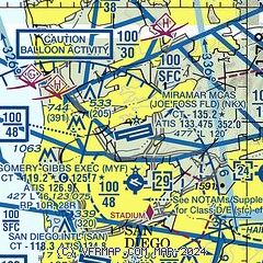
| Sectional chart |
|---|
|
 Download PDF
of official airport diagram from the FAA
| Airport distance calculator |
|---|
|
|
| Sunrise and sunset |
|---|
|
Times for 18-Apr-2024
| | Local
(UTC-7) | | Zulu
(UTC) |
|---|
| Morning civil twilight | | 05:49 | | 12:49 |
| Sunrise | | 06:15 | | 13:15 |
| Sunset | | 19:20 | | 02:20 |
| Evening civil twilight | | 19:46 | | 02:46 |
|
| Current date and time |
|---|
| Zulu (UTC) | 19-Apr-2024 00:38:19 |
|---|
| Local (UTC-7) | 18-Apr-2024 17:38:19 |
|---|
|
| METAR |
|---|
| KNKX | 182355Z 21007KT 8SM CLR 17/12 A2997 RMK AO2 SLP144 T01670117 10222 20167 56008
|
KMYF
3nm S | 182353Z 26004KT 10SM CLR 18/12 A2998 RMK AO2 SLP148 T01780117 10228 20178 56007
|
KSAN
8nm S | 182351Z 20006KT 10SM FEW020 SCT250 18/12 A2999 RMK AO2 SLP155 T01780117 10222 20178 58007 $
|
KSEE
9nm E | 182347Z 22010KT 10SM SKC 20/11 A2997
|
KNZY
11nm S | 182352Z VRB04KT 10SM SCT016 SCT250 17/13 A2997 RMK AO2 SLP148 T01670128 10200 20167 58008 $
|
KRNM
15nm NE | 182353Z 28008KT 10SM CLR 21/13 A2996 RMK AO2 SLP138 T02060128 10250 20206 56009
|
KCRQ
17nm NW | 182353Z AUTO 23009KT 10SM FEW015 16/11 A2996 RMK AO2 SLP144 T01610111 10206 20161 56009
|
KNRS
18nm S | 182353Z 26008KT BKN014 BKN200 M17/ A2999 RMK AO2 SLP154 60000 T1167 10194 21167 58008 $
|
KSDM
19nm SE | 182353Z 9SM CLR 18/12 A2997 RMK AO2 SLP147 T01830117 10244 20172 56008
|
|
| TAF |
|---|
| KNKX | 1721/1821 27009KT 9999 FEW050 QNH2997INS BECMG 1803/1805 27003KT 9999 FEW050 QNH2998INS BECMG 1818/1820 24006KT 9999 FEW120 QNH2997INS T22/1721Z T10/1813Z
|
KSAN
8nm S | 182045Z 1821/1924 23011KT P6SM SCT200 FM190200 VRB04KT P6SM OVC015 FM192000 26009KT P6SM SCT015
|
KNZY
11nm S | 1723/1823 29006KT 9999 FEW008 SCT250 QNH2996INS BECMG 1802/1804 VRB06KT 9999 BKN007 BKN250 QNH2995INS TEMPO 1804/1810 00000KT 8000 BR OVC005 BECMG 1810/1812 26006KT 9999 OVC008 QNH2996INS BECMG 1818/1820 24008KT 9999 SCT010 SCT250 QNH2994INS TX20/1822Z TN10/1813Z FS30196
|
KCRQ
17nm NW | 181956Z 1820/1918 24012KT P6SM SCT200 FM190200 VRB04KT P6SM OVC012
|
|
| NOTAMs |
|---|
NOTAMs are issued by the DoD/FAA and will open in a separate window not controlled by AirNav.
|
|

