FAA INFORMATION EFFECTIVE 21 MARCH 2024
Location
| FAA Identifier: | O05 |
| Lat/Long: | 40-16-56.5000N 121-14-28.2000W
40-16.941667N 121-14.470000W
40.2823611,-121.2411667
(estimated) |
| Elevation: | 4534.4 ft. / 1382.1 m (surveyed) |
| Variation: | 17E (1985) |
| From city: | 2 miles SW of CHESTER, CA |
| Time zone: | UTC -7 (UTC -8 during Standard Time) |
| Zip code: | 96020 |
Airport Operations
| Airport use: | Open to the public |
| Activation date: | 04/1940 |
| Control tower: | no |
| ARTCC: | OAKLAND CENTER |
| FSS: | RANCHO MURIETA FLIGHT SERVICE STATION |
| NOTAMs facility: | RIU (NOTAM-D service available) |
| Attendance: | 0800-DUSK |
| Wind indicator: | lighted |
| Segmented circle: | yes |
| Lights: | ACTVT MIRL RY 16/34 & PAPI RYS 16 & 34 - CTAF. |
| Beacon: | white-green (lighted land airport)
Operates sunset to sunrise. |
Airport Communications
| CTAF/UNICOM: | 122.8 |
| WX AWOS-3: | 118.275 (530-258-2860) |
Airport Services
| Fuel available: | 100LL JET-A |
| Parking: | tiedowns |
| Airframe service: | NONE |
| Powerplant service: | NONE |
| Bottled oxygen: | NONE |
| Bulk oxygen: | NONE |
Runway Information
Runway 16/34
| Dimensions: | 5020 x 100 ft. / 1530 x 30 m |
| Surface: | asphalt, in fair condition |
| Weight bearing capacity: | | Single wheel: | 60.0, ESTIMATED BY OWNER. | | Double wheel: | 110.0 |
|
| Runway edge lights: | medium intensity |
| RUNWAY 16 | | RUNWAY 34 |
| Latitude: | 40-17.352133N | | 40-16.531320N |
| Longitude: | 121-14.534187W | | 121-14.406538W |
| Elevation: | 4534.4 ft. | | 4513.5 ft. |
| Traffic pattern: | left | | right |
| Runway heading: | 156 magnetic, 173 true | | 336 magnetic, 353 true |
| Markings: | nonprecision, in fair condition | | nonprecision, in fair condition |
| Visual slope indicator: | 2-light PAPI on left (3.00 degrees glide path) | | 2-light PAPI on left (3.00 degrees glide path) |
| Runway end identifier lights: | no | | no |
| Touchdown point: | yes, no lights | | yes, no lights |
| Obstructions: | 50 ft. trees, 1200 ft. from runway, 375 ft. left of centerline, 20:1 slope to clear | | 67 ft. trees, 2500 ft. from runway, 350 ft. left of centerline, 34:1 slope to clear |
Airport Ownership and Management from official FAA records
| Ownership: | Publicly-owned |
| Owner: | COUNTY OF PLUMAS
198 ANDY'S WAY
QUINCY, CA 95971-7007
Phone 530-283-6299 |
| Manager: | JD MOORE
198 ANDY'S WAY
QUINCY, CA 95971-7007
Phone 530-283-6069
AIRPORT FBO PHONE 530-258-3616. |
Airport Operational Statistics
| Aircraft based on the field: | | 10 | | Single engine airplanes: | | 8 | | Multi engine airplanes: | | 1 | | Jet airplanes: | | 1 |
- PLUS SEVERAL FIRE BOMBERS DURING SUMMER.
| |  | |
| Aircraft operations: avg 43/day * | | 54% | transient general aviation | | 41% | local general aviation | | 4% | air taxi | | * for 12-month period ending 31 December 2022 | |
Additional Remarks
| E93 | TWO 40' DIAMETER CONC HELIPADS /USFS/ ON FLD. |
| - | FOR CD CTC OAKLAND ARTCC AT 510-745-3380. |
Instrument Procedures
There are no published instrument procedures at O05.
Some nearby airports with instrument procedures:
KSVE - Susanville Municipal Airport (31 nm E)
KCIC - Chico Regional Airport (41 nm SW)
KRBL - Red Bluff Municipal Airport (47 nm W)
O02 - Nervino Airport (49 nm SE)
KAHC - Amedee Army Airfield (50 nm E)
|
|

Road maps at:
MapQuest
Bing
Google
| Aerial photo |
|---|
WARNING: Photo may not be current or correct

Do you have a better or more recent aerial photo of Rogers Field Airport that you would like to share? If so, please send us your photo.
|
| Sectional chart |
|---|
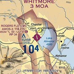
|
| Airport distance calculator |
|---|
|
|
| Sunrise and sunset |
|---|
|
Times for 17-Apr-2024
| | Local
(UTC-7) | | Zulu
(UTC) |
|---|
| Morning civil twilight | | 05:55 | | 12:55 |
| Sunrise | | 06:23 | | 13:23 |
| Sunset | | 19:46 | | 02:46 |
| Evening civil twilight | | 20:14 | | 03:14 |
|
| Current date and time |
|---|
| Zulu (UTC) | 17-Apr-2024 09:35:01 |
|---|
| Local (UTC-7) | 17-Apr-2024 02:35:01 |
|---|
|
| METAR |
|---|
KSVE
31nm E | 170915Z AUTO 17005KT 10SM CLR 06/02 A3014 RMK AO2
|
KCIC
40nm SW | 170915Z AUTO 00000KT 10SM CLR 13/10 A3007 RMK AO1
|
KO54
47nm W | 170915Z AUTO 00000KT 10SM CLR 05/03 A3016 RMK A01
|
KRBL
47nm W | 170854Z AUTO 00000KT 10SM CLR 12/09 A3007 RMK AO2 SLP180 T01220089 58001
|
|
| TAF |
|---|
KRBL
47nm W | 170520Z 1706/1806 VRB05KT P6SM BKN250 FM170900 33007KT P6SM BKN250 FM171400 34012G20KT P6SM BKN250 FM172200 34007KT P6SM BKN250
|
|
| NOTAMs |
|---|
NOTAMs are issued by the DoD/FAA and will open in a separate window not controlled by AirNav.
|
|

