FAA INFORMATION EFFECTIVE 18 APRIL 2024
Location
| FAA Identifier: | OCH |
| Lat/Long: | 31-34-39.9500N 094-42-36.4000W
31-34.665833N 094-42.606667W
31.5777639,-94.7101111
(estimated) |
| Elevation: | 343.1 ft. / 104.6 m (surveyed) |
| Variation: | 05E (1995) |
| From city: | 3 miles SW of NACOGDOCHES, TX |
| Time zone: | UTC -5 (UTC -6 during Standard Time) |
| Zip code: | 75964 |
Airport Operations
| Airport use: | Open to the public |
| Activation date: | 04/1944 |
| Control tower: | no |
| ARTCC: | HOUSTON CENTER |
| FSS: | MONTGOMERY COUNTY FLIGHT SERVICE STATION |
| NOTAMs facility: | OCH (NOTAM-D service available) |
| Attendance: | 0800-1700 |
| Wind indicator: | lighted |
| Segmented circle: | yes |
| Lights: | DUSK-DAWN, MIRL RWY 18/36 PRESET LOW INTST. TO INCR INTST & ACTVT MALSR RWY 36; REIL RWY 18 - CTAF. |
| Beacon: | white-green (lighted land airport)
Operates sunset to sunrise. |
Airport Communications
| CTAF/UNICOM: | 123.0 |
| WX AWOS-3PT: | 135.625 (936-564-5074) |
- APCH/DEP CTL SVC PRVDD BY HOUSTON ARTCC (ZHU) ON FREQS 125.175/285.575 (LUFKIN RCAG).
Nearby radio navigation aids
| VOR radial/distance | | VOR name | | Freq | | Var |
|---|
| LFKr356/24.9 | | LUFKIN VORTAC | | 112.10 | | 05E |
| NDB name | | Hdg/Dist | | Freq | | Var | | ID |
|---|
| NADOS | | 000/5.6 | | 253 | | 05E | | OC | --- -.-. |
| AMASON | | 238/32.3 | | 341 | | 04E | | CZJ | -.-. --.. .--- |
Airport Services
| Fuel available: | 100LL JET-A+
100LL:24 HR SELF SERVE 100LL AND JET A+ WITH MAJOR CC; FULL SERVE 100LL & JET A+ AVBL FM TRUCK DRG BUS HRS OR WITH ARRANGED AFT HRS CALL OUT. ARPT TEL NR IS 936-560-9567; OTR NRS POSTED AT ARPT. |
| Parking: | tiedowns |
| Airframe service: | MAJOR |
| Powerplant service: | MAJOR |
| Bottled oxygen: | NONE |
| Bulk oxygen: | NONE |
Runway Information
Runway 18/36
| Dimensions: | 5000 x 75 ft. / 1524 x 23 m |
| Surface: | asphalt, in good condition |
| Weight bearing capacity: | |
| Runway edge lights: | medium intensity |
| Operational restrictions: | NO LN OF SIGHT BTN RWY ENDS. |
| RUNWAY 18 | | RUNWAY 36 |
| Latitude: | 31-35.077283N | | 31-34.255100N |
| Longitude: | 094-42.569967W | | 094-42.645467W |
| Elevation: | 337.3 ft. | | 326.6 ft. |
| Traffic pattern: | left | | left |
| Runway heading: | 179 magnetic, 184 true | | 359 magnetic, 004 true |
| Markings: | precision, in good condition | | precision, in good condition |
| Visual slope indicator: | 2-light PAPI on left (3.00 degrees glide path) | | 2-light PAPI on left (3.00 degrees glide path) |
| Approach lights: | | | MALSR: 1,400 foot medium intensity approach lighting system with runway alignment indicator lights |
| Runway end identifier lights: | yes | | no |
| Touchdown point: | yes, no lights | | yes, no lights |
| Instrument approach: | | | ILS/DME |
| Obstructions: | 59 ft. trees, 259 ft. from runway, 490 ft. left of centerline, 1:1 slope to clear | | 119 ft. trees, 2900 ft. from runway, 935 ft. both sides of centerline, 22:1 slope to clear |
Airport Ownership and Management from official FAA records
| Ownership: | Publicly-owned |
| Owner: | CITY OF NACOGDOCHES
PO BOX 635030
NACOGDOCHES, TX 75963-5030
Phone 936-559-2502 |
| Manager: | COLIN SMITH
556 TERRY CRAWFORD, OFC
NACOGDOCHES, TX 75964
Phone 936-560-9567
ARPT ATTENDANT/FBO. AMGR OFC 936-560-9567. |
Airport Operational Statistics
| Aircraft based on the field: | | 56 | | Single engine airplanes: | | 47 | | Multi engine airplanes: | | 5 | | Jet airplanes: | | 4 |
| |  | |
| Aircraft operations: avg 110/day * | | 74% | local general aviation | | 25% | transient general aviation | | <1% | military | | * for 12-month period ending 01 April 2023 | |
Additional Remarks
| - | 35 FT AGL ANT 400 FT WEST OF CNTRLN RWY 18/36. |
| - | BIRDS ON AND INVOF ARPT. |
| - | FOR CD CTC HOUSTON ARTCC AT 281-230-5622. |
| - | HIGH INTSTY STUDENT PILOT TRNG IN AND ARND ARPT. MNT 122.75 FOR STUDENT AREAS OF ACTVTY. |
Instrument Procedures
NOTE: All procedures below are presented as PDF files. If you need a reader for these files, you should download the free Adobe Reader.NOT FOR NAVIGATION. Please procure official charts for flight.
FAA instrument procedures published for use from 18 April 2024 at 0901Z to 16 May 2024 at 0900Z.
IAPs - Instrument Approach Procedures |
|---|
| ILS OR LOC RWY 36 | |
download (335KB) |
| RNAV (GPS) RWY 18 | |
download (203KB) |
| RNAV (GPS) RWY 36 | |
download (248KB) |
| NOTE: Special Alternate Minimums apply | |
download (44KB) |
| NOTE: Special Take-Off Minimums/Departure Procedures apply | |
download (109KB) |
Other nearby airports with instrument procedures:
KLFK - Angelina County Airport (21 nm S)
KJSO - Cherokee County Airport (31 nm NW)
F17 - Center Municipal Airport (32 nm NE)
KRFI - Rusk County Airport (35 nm N)
KDKR - Houston County Airport (39 nm SW)
|
|

Road maps at:
MapQuest
Bing
Google
| Aerial photo |
|---|
WARNING: Photo may not be current or correct
 Photo by Jason Reina
Photo taken 13-Oct-2020
looking southwest.
Photo by Jason Reina
Photo taken 13-Oct-2020
looking southwest.
Do you have a better or more recent aerial photo of Nacogdoches A L Mangham Jr. Regional Airport that you would like to share? If so, please send us your photo.
|
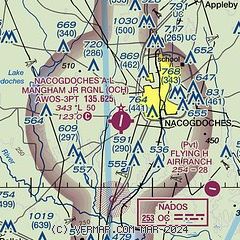
| Sectional chart |
|---|
|
| Airport distance calculator |
|---|
|
|
| Sunrise and sunset |
|---|
|
Times for 25-Apr-2024
| | Local
(UTC-5) | | Zulu
(UTC) |
|---|
| Morning civil twilight | | 06:14 | | 11:14 |
| Sunrise | | 06:39 | | 11:39 |
| Sunset | | 19:54 | | 00:54 |
| Evening civil twilight | | 20:19 | | 01:19 |
|
| Current date and time |
|---|
| Zulu (UTC) | 25-Apr-2024 09:58:57 |
|---|
| Local (UTC-5) | 25-Apr-2024 04:58:57 |
|---|
|
| METAR |
|---|
| KOCH | 250856Z AUTO 00000KT 10SM CLR 18/ A3006 RMK AO2 SLP180 T0178 58011
|
|
| TAF |
|---|
KLFK
21nm S | 250540Z 2506/2606 15004KT P6SM FEW040 SCT250 FM251000 14003KT P6SM SCT010 SCT180 BKN250 TEMPO 2510/2514 3SM BR BKN010 FM251500 15008KT P6SM BKN015 BKN250 FM251800 16012G18KT P6SM BKN035 BKN250 FM260000 15010KT P6SM BKN050 BKN150 BKN250
|
|
| NOTAMs |
|---|
NOTAMs are issued by the DoD/FAA and will open in a separate window not controlled by AirNav.
|
|
