FAA INFORMATION EFFECTIVE 18 APRIL 2024
Location
| FAA Identifier: | PCW |
| Lat/Long: | 41-30-58.5740N 082-52-10.1520W
41-30.976233N 082-52.169200W
41.5162706,-82.8694867
(estimated) |
| Elevation: | 590.1 ft. / 179.9 m (surveyed) |
| Variation: | 07W (2010) |
| From city: | 3 miles E of PORT CLINTON, OH |
| Time zone: | UTC -4 (UTC -5 during Standard Time) |
| Zip code: | 43452 |
Airport Operations
| Airport use: | Open to the public |
| Activation date: | 07/1971 |
| Control tower: | no |
| ARTCC: | CLEVELAND CENTER |
| FSS: | CLEVELAND FLIGHT SERVICE STATION |
| NOTAMs facility: | CLE (NOTAM-D service available) |
| Attendance: | 0700-1700 |
| Wind indicator: | lighted |
| Segmented circle: | no |
| Lights: | ACTVT REIL RWY 09 & 27; HIRL RWY 09/27; MIRL RWY 18/36 - CTAF. PAPI RWY 09 & 27 OPR CONSLY. |
| Beacon: | white-green (lighted land airport)
Operates sunset to sunrise. |
| International operations: | customs landing rights airport |
Airport Communications
| CTAF/UNICOM: | 122.8 |
| WX AWOS-3: | 118.775 (419-734-9955) |
| CLEVELAND APPROACH: | 126.35 |
| CLEVELAND DEPARTURE: | 126.35 |
| WX AWOS-3P at S24 (15 nm SW): | 119.575 (419-547-6932) |
Nearby radio navigation aids
| VOR radial/distance | | VOR name | | Freq | | Var |
|---|
| DJBr292/33.2 | | DRYER VOR/DME | | 113.60 | | 05W |
| NDB name | | Hdg/Dist | | Freq | | Var | | ID |
|---|
| PORT CLINTON | | at field | | 423 | | 07W | | PCW | .--. -.-. .-- |
| TIFFIN | | 037/29.7 | | 269 | | 05W | | TII | - .. .. |
| GROSSE ILE | | 167/37.3 | | 419 | | 07W | | RYS | .-. -.-- ... |
Airport Services
| Fuel available: | 100LL JET-A+ |
| Parking: | hangars and tiedowns |
| Airframe service: | MAJOR |
| Powerplant service: | MAJOR |
| Bottled oxygen: | HIGH/LOW |
| Bulk oxygen: | HIGH/LOW |
Runway Information
Runway 9/27
| Dimensions: | 5646 x 100 ft. / 1721 x 30 m |
| Surface: | asphalt/grooved, in good condition |
| Weight bearing capacity: | |
| Runway edge lights: | high intensity |
| Operational restrictions: | CALM WIND RWY. |
| RUNWAY 9 | | RUNWAY 27 |
| Latitude: | 41-30.961708N | | 41-31.081315N |
| Longitude: | 082-52.900140W | | 082-51.673483W |
| Elevation: | 588.7 ft. | | 588.2 ft. |
| Traffic pattern: | left | | left |
| Runway heading: | 090 magnetic, 083 true | | 270 magnetic, 263 true |
| Displaced threshold: | no | | 201 ft. |
| Markings: | nonprecision, in good condition | | nonprecision, in good condition |
| Visual slope indicator: | 4-light PAPI on left (3.00 degrees glide path) | | 4-light PAPI on left (3.00 degrees glide path) |
| Runway end identifier lights: | yes | | yes |
| Touchdown point: | yes, no lights | | yes, no lights |
| Obstructions: | 65 ft. tree, 1659 ft. from runway, 402 ft. right of centerline, 22:1 slope to clear | | 42 ft. tree, 1098 ft. from runway, 334 ft. right of centerline, 21:1 slope to clear |
Runway 18/36
| Dimensions: | 4002 x 75 ft. / 1220 x 23 m |
| Surface: | asphalt, in good condition |
| Runway edge lights: | medium intensity |
| RUNWAY 18 | | RUNWAY 36 |
| Latitude: | 41-31.241588N | | 41-30.583033N |
| Longitude: | 082-52.019652W | | 082-51.986897W |
| Elevation: | 586.1 ft. | | 589.0 ft. |
| Traffic pattern: | left | | left |
| Runway heading: | 185 magnetic, 178 true | | 005 magnetic, 358 true |
| Markings: | basic, in fair condition | | basic, in fair condition |
| Runway end identifier lights: | no | | no |
| Touchdown point: | yes, no lights | | yes, no lights |
Airport Ownership and Management from official FAA records
| Ownership: | Publicly-owned |
| Owner: | ERIE OTTAWA ARPT AUTH
3255 E STATE RD
PORT CLINTON, OH 43452-2542
Phone 419-734-6297 |
| Manager: | CLAYTON F FINKEN
3255 E STATE RD
PORT CLINTON, OH 43452-2542
Phone 419-734-6297 |
Airport Operational Statistics
| Aircraft based on the field: | | 98 | | Single engine airplanes: | | 80 | | Multi engine airplanes: | | 11 | | Jet airplanes: | | 7 |
| |  | |
| Aircraft operations: avg 148/day * | | 46% | local general aviation | | 28% | transient general aviation | | 26% | air taxi | | <1% | military | | * for 12-month period ending 21 October 2020 | |
Additional Remarks
| - | TXL A CLSD TO ACFT WITH WINGSPAN GTR THAN 49 FT. |
| - | BIRDS & OTR WILDLIFE ON & INVOF ARPT. |
| - | FOR CD CTC CLEVELAND APCH AT 216-352-2323. |
| - | CUST AVBL 24 HRS 7 DAYS PER WEEK. REQ MUST BE MADE PRIOR TO ARR. LCL OFC 419-732-4446. |
Instrument Procedures
NOTE: All procedures below are presented as PDF files. If you need a reader for these files, you should download the free Adobe Reader.NOT FOR NAVIGATION. Please procure official charts for flight.
FAA instrument procedures published for use from 18 April 2024 at 0901Z to 16 May 2024 at 0900Z.
IAPs - Instrument Approach Procedures |
|---|
| RNAV (GPS) RWY 09 | |
download (206KB) |
| RNAV (GPS) RWY 27 | |
download (198KB) |
| NDB RWY 27 | |
download (246KB) |
| NOTE: Special Alternate Minimums apply | |
download (145KB) |
| NOTE: Special Take-Off Minimums/Departure Procedures apply | |
download (482KB) |
Other nearby airports with instrument procedures:
S24 - Sandusky County Regional Airport (15 nm SW)
14G - Fremont Airport (17 nm SW)
5A1 - Norwalk-Huron County Airport (22 nm SE)
KTDZ - Toledo Executive Airport (28 nm W)
8G1 - Willard Airport (29 nm S)
|
|

Road maps at:
MapQuest
Bing
Google
| Aerial photo |
|---|
WARNING: Photo may not be current or correct
 Photo by Tal Reichert
Photo taken 29-Jul-2012
looking northeast.
Photo by Tal Reichert
Photo taken 29-Jul-2012
looking northeast.
Do you have a better or more recent aerial photo of Erie-Ottawa International Airport that you would like to share? If so, please send us your photo.
|
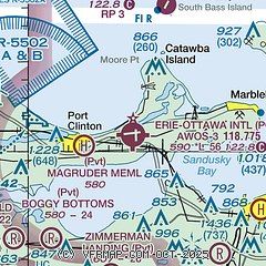
| Sectional chart |
|---|
|
| Airport distance calculator |
|---|
|
|
| Sunrise and sunset |
|---|
|
Times for 25-Apr-2024
| | Local
(UTC-4) | | Zulu
(UTC) |
|---|
| Morning civil twilight | | 06:07 | | 10:07 |
| Sunrise | | 06:36 | | 10:36 |
| Sunset | | 20:22 | | 00:22 |
| Evening civil twilight | | 20:52 | | 00:52 |
|
| Current date and time |
|---|
| Zulu (UTC) | 25-Apr-2024 06:55:35 |
|---|
| Local (UTC-4) | 25-Apr-2024 02:55:35 |
|---|
|
| METAR |
|---|
| KPCW | 250635Z AUTO 05004KT 10SM CLR 02/M01 A3030 RMK AO2
|
|
| TAF |
|---|
KTOL
42nm W | 250520Z 2506/2606 VRB03KT P6SM SKC FM251500 06006KT P6SM SKC
|
KMFD
45nm S | 250520Z 2506/2606 02004KT P6SM SKC TEMPO 2507/2509 BKN030 FM251500 03006KT P6SM SKC
|
CYQG
46nm N | 250540Z 2506/2606 36007KT P6SM SKC BECMG 2514/2516 05010KT FM252100 08010KT P6SM FEW040 BECMG 2600/2602 10006KT BECMG 2604/2606 07007KT RMK FCST BASED ON AUTO OBS. NXT FCST BY 251200Z
|
KCLE
46nm E | 250520Z 2506/2612 36005KT P6SM SKC TEMPO 2506/2508 BKN035 FM251500 03007KT P6SM SKC
|
KFDY
47nm SW | 250520Z 2506/2606 05004KT P6SM SKC TEMPO 2506/2508 BKN030 FM251500 06007KT P6SM SKC
|
KDTW
48nm NW | 250520Z 2506/2612 02005KT P6SM SKC FM251400 08005KT P6SM FEW040 FM252000 12007KT P6SM SKC FM260100 10005KT P6SM SCT250
|
|
| NOTAMs |
|---|
NOTAMs are issued by the DoD/FAA and will open in a separate window not controlled by AirNav.
|
|


