FAA INFORMATION EFFECTIVE 21 MARCH 2024
Location
| FAA Identifier: | RMN |
| Lat/Long: | 38-23-53.2000N 077-27-19.7000W
38-23.886667N 077-27.328333W
38.3981111,-77.4554722
(estimated) |
| Elevation: | 211.2 ft. / 64.4 m (surveyed) |
| Variation: | 10W (2000) |
| From city: | 3 miles SW of STAFFORD, VA |
| Time zone: | UTC -4 (UTC -5 during Standard Time) |
| Zip code: | 22406 |
Airport Operations
| Airport use: | Open to the public |
| Activation date: | 10/2001 |
| Control tower: | no |
| ARTCC: | WASHINGTON CENTER |
| FSS: | LEESBURG FLIGHT SERVICE STATION |
| NOTAMs facility: | RMN (NOTAM-D service available) |
| Attendance: | 0800-1800
UNATNDD THANKSGIVING, CHRISTMAS, & NEW YEARS DAYS. |
| Wind indicator: | lighted |
| Segmented circle: | yes |
| Lights: | ACTVT MALS RWY 33; REIL RWY 15; HIRL RWY 15/33 - CTAF. |
| Beacon: | white-green (lighted land airport)
Operates sunset to sunrise. |
Airport Communications
| CTAF/UNICOM: | 122.725 |
| WX AWOS-3: | 126.325 (540-657-8283) |
| QUANTICO APPROACH: | 127.05 |
| POTOMAC APPROACH: | 128.525 ;WHEN NYG TWR CLSD |
| QUANTICO DEPARTURE: | 127.05 |
| POTOMAC DEPARTURE: | 128.525 ;WHEN NYG TWR CLSD |
| HYPER STAR: | 133.0 |
| TIKEE STAR: | 120.45 |
| TRSTN STAR: | 126.75 |
| WX AWOS-3 at EZF (8 nm S): | 128.125 (540-372-6794) |
| WX AWOS-3 at HWY (16 nm NW): | 120.350 (540-788-4078) |
| WX AWOS-3PT at HEF (20 nm N): | PHONE 703-361-6160 |
- APCH/DEP SVC PRVDD BY POTOMAC TRACON (PCT) ON 128.525/ 306.925 WHEN QUANTICO (NYG) CLSD.
Nearby radio navigation aids
| VOR radial/distance | | VOR name | | Freq | | Var |
|---|
| BRVr317/6.1 | | BROOKE VORTAC | | 114.50 | | 09W |
| CSNr133/24.2 | | CASANOVA VORTAC | | 116.30 | | 06W |
| AMLr187/32.2 | | ARMEL VOR/DME | | 113.50 | | 08W |
| DCAr224/33.9 | | WASHINGTON VOR/DME | | 111.00 | | 09W |
| ADWr238/37.0 | | ANDREWS VORTAC | | 113.10 | | 10W |
| NDB name | | Hdg/Dist | | Freq | | Var | | ID |
|---|
| SHANNON | | 008/7.9 | | 237 | | 10W | | EZF | . --.. ..-. |
| NAILR | | 109/21.4 | | 351 | | 10W | | MSQ | -- ... --.- |
| DAVEE | | 235/22.6 | | 223 | | 09W | | DAA | -.. .- .- |
| OXONN | | 233/29.8 | | 332 | | 11W | | DCA | -.. -.-. .- |
| GEORGETOWN | | 215/35.5 | | 323 | | 09W | | GTN | --. - -. |
Airport Services
| Fuel available: | 100LL JET-A
100LL:FUEL AVBL UNTIL 1800; AFTER HRS CALL 540-288-3838 WITHIN 12 HRS NOTICE. PRIST AVBL.
A:GOVT CONTR FUEL. |
| Parking: | tiedowns |
| Airframe service: | MINOR |
| Powerplant service: | MINOR |
| Bottled oxygen: | LOW |
Runway Information
Runway 15/33
| Dimensions: | 5000 x 100 ft. / 1524 x 30 m |
| Surface: | asphalt/grooved, in good condition |
| Weight bearing capacity: | | Single wheel: | 30.0 | | Double wheel: | 70.0 |
|
| Runway edge lights: | high intensity |
| RUNWAY 15 | | RUNWAY 33 |
| Latitude: | 38-24.197408N | | 38-23.574242N |
| Longitude: | 077-27.670310W | | 077-26.985673W |
| Elevation: | 211.2 ft. | | 171.2 ft. |
| Traffic pattern: | left | | left |
| Runway heading: | 149 magnetic, 139 true | | 329 magnetic, 319 true |
| Markings: | nonprecision, in good condition | | precision, in good condition |
| Visual slope indicator: | 4-light PAPI on left (3.00 degrees glide path) | | 4-light PAPI on left (3.00 degrees glide path) |
| Approach lights: | | | MALS: 1,400 foot medium intensity approach lighting system |
| Runway end identifier lights: | yes | | no |
| Touchdown point: | yes, no lights | | yes, no lights |
| Instrument approach: | | | ILS/DME |
| Obstructions: | 28 ft. trees, 1227 ft. from runway, 10 ft. right of centerline, 36:1 slope to clear | | 36 ft. trees, 441 ft. from runway, 503 ft. right of centerline, 6:1 slope to clear |
Airport Ownership and Management from official FAA records
| Ownership: | Publicly-owned |
| Owner: | STATE
95 AVIATION WAY
FREDERICKSBURG, VA 22406
Phone 540-658-1212 |
| Manager: | JAMES STOVER
95 AVIATION WAY
FREDERICKSBURG, VA 22406
Phone 540-658-1212 |
Airport Operational Statistics
| Aircraft based on the field: | | 88 | | Single engine airplanes: | | 77 | | Multi engine airplanes: | | 5 | | Helicopters: | | 6 |
| |  | |
| Aircraft operations: avg 83/day * | | 67% | transient general aviation | | 26% | local general aviation | | 7% | military | | * for 12-month period ending 31 December 2018 | |
Additional Remarks
| - | DEER & FLOCKS OF BIRDS ON & INVOF ARPT. |
| - | GCO AVBL ON FREQ 135.075 SERVICED BY QUANTICO AND POTOMAC APP. IF UNA, FOR CD CTC POTOMAC APCH AT 866-709-4993. |
| - | NOISE: IN EFF 24 HRS. VFR ACFT DEPARTING RWY 33 FLY RWY HEADING UNTIL BASEBALL FIELDS 1 NM THEN TURN LEFT. |
Instrument Procedures
NOTE: All procedures below are presented as PDF files. If you need a reader for these files, you should download the free Adobe Reader.NOT FOR NAVIGATION. Please procure official charts for flight.
FAA instrument procedures published for use from 21 March 2024 at 0901Z to 18 April 2024 at 0900z.
STARs - Standard Terminal Arrivals |
|---|
| HYPER NINE (RNAV) **NEW** | |
2 pages:
[1] [2] (382KB) |
| HYPER NINE (RNAV), CONT.2 **NEW** | |
download (164KB) |
| TIKEE FOUR (RNAV) | |
download (215KB) |
IAPs - Instrument Approach Procedures |
|---|
| ILS OR LOC RWY 33 **CHANGED** | |
download (295KB) |
| RNAV (GPS) RWY 33 **CHANGED** | |
download (288KB) |
| VOR RWY 33 **CHANGED** | |
download (240KB) |
| NOTE: Special Alternate Minimums apply | |
download (166KB) |
| NOTE: Special Take-Off Minimums/Departure Procedures apply | |
download (154KB) |
Other nearby airports with instrument procedures:
KEZF - Shannon Airport (8 nm S)
KNYG - Quantico Marine Corps Air Facility (Turner Field) (9 nm NE)
KHWY - Warrenton/Fauquier Airport (16 nm NW)
KHEF - Manassas Regional Airport/Harry P. Davis Field (20 nm N)
KCJR - Culpeper Regional Airport (20 nm W)
|
|

Road maps at:
MapQuest
Bing
Google
| Aerial photo |
|---|
WARNING: Photo may not be current or correct
 Photo by Roger W. Snyder
Photo taken 31-Mar-2014
looking northwest.
Photo by Roger W. Snyder
Photo taken 31-Mar-2014
looking northwest.
Do you have a better or more recent aerial photo of Stafford Regional Airport that you would like to share? If so, please send us your photo.
|
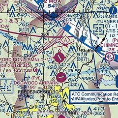
| Sectional chart |
|---|
|
CAUTION: Diagram may not be current

| Airport distance calculator |
|---|
|
|
| Sunrise and sunset |
|---|
|
Times for 16-Apr-2024
| | Local
(UTC-4) | | Zulu
(UTC) |
|---|
| Morning civil twilight | | 06:05 | | 10:05 |
| Sunrise | | 06:32 | | 10:32 |
| Sunset | | 19:47 | | 23:47 |
| Evening civil twilight | | 20:14 | | 00:14 |
|
| Current date and time |
|---|
| Zulu (UTC) | 16-Apr-2024 12:06:35 |
|---|
| Local (UTC-4) | 16-Apr-2024 08:06:35 |
|---|
|
| METAR |
|---|
| KRMN | 161155Z AUTO 00000KT 10SM CLR 14/06 A3018 RMK AO2 70068 T01380056 10188 20102
|
KEZF
8nm S | 161155Z AUTO 00000KT 10SM CLR 16/09 A3017 RMK AO2 70053 T01560085 10185 20130
|
KNYG
10nm NE | 161156Z 29004KT 9SM FEW080 14/07 A3019 RMK AO2 SLP224 70057 T01440072 10211 20128 51030 $
|
KHWY
16nm NW | 161155Z AUTO 00000KT 10SM CLR 13/05 A3019 RMK AO2 70018 T01300050 10191 20071
|
KHEF
19nm N | 161156Z 00000KT 10SM CLR 14/07 A3019 RMK AO2 SLP228 T01390067 10206 20100 53028
|
|
| TAF |
|---|
KNYG
10nm NE | 1609/1709 02010KT 9999 FEW050 SCT200 QNH3006INS BECMG 1612/1614 VRB06KT 9999 SCT080 QNH3010INS FM161500 VRB06KT 9999 SCT130 QNH3009INS T23/1620Z T12/1707Z
|
|
| NOTAMs |
|---|
NOTAMs are issued by the DoD/FAA and will open in a separate window not controlled by AirNav.
|
|


