FAA INFORMATION EFFECTIVE 18 APRIL 2024
Location
| FAA Identifier: | SFF |
| Lat/Long: | 47-40-58.5860N 117-19-20.7340W
47-40.976433N 117-19.345567W
47.6829406,-117.3224261
(estimated) |
| Elevation: | 1956.7 ft. / 596.4 m (surveyed) |
| Variation: | 16E (2010) |
| From city: | 4 miles NE of SPOKANE, WA |
| Time zone: | UTC -7 (UTC -8 during Standard Time) |
| Zip code: | 99212 |
Airport Operations
| Airport use: | Open to the public |
| Activation date: | 10/1937 |
| Control tower: | yes |
| ARTCC: | SEATTLE CENTER |
| FSS: | SEATTLE FLIGHT SERVICE STATION |
| NOTAMs facility: | SFF (NOTAM-D service available) |
| Attendance: | 0600-2000 |
| Wind indicator: | lighted |
| Segmented circle: | yes |
| Lights: | WHEN ATCT CLSD ACTVT MIRL RY 04L/22R, MALSR RY 22R AND REIL RY 04L - CTAF. VASI RY 04L & VASI RY 22R OPER CONTINUOUSLY. PAPI RY 22L OPER SR-SS. |
| Beacon: | white-green (lighted land airport)
Operates sunset to sunrise. |
| International operations: | customs landing rights airport |
Airport Communications
| CTAF: | 132.5 |
| UNICOM: | 122.95 |
| ATIS: | 120.55 |
| WX ASOS: | 120.55 (509-535-3290) |
| FELTS GROUND: | 121.7 [0600-2000] |
| FELTS TOWER: | 132.5 239.025 [0600-2000] |
| SPOKANE APPROACH: | 133.35 |
| SPOKANE DEPARTURE: | 133.35 |
| CLEARANCE DELIVERY: | 121.7 ;0400-1400Z |
| HILIE STAR: | 133.35 |
| ZOOMR STAR: | 123.75 |
| WX ASOS at GEG (9 nm SW): | PHONE 509-742-2544 |
| WX ASOS at DEW (18 nm N): | 135.175 (509-276-2303) |
- EMERGENCY FREQ 121.5 NOT AVBL AT ATCT.
Nearby radio navigation aids
| VOR radial/distance | | VOR name | | Freq | | Var |
|---|
| GEGr046/14.2 | | SPOKANE VORTAC | | 115.50 | | 14E |
| COEr236/21.0 | | COEUR D'ALENE VOR/DME | | 108.80 | | 19E |
| NDB name | | Hdg/Dist | | Freq | | Var | | ID |
|---|
| DEER PARK | | 150/17.6 | | 365 | | 16E | | DPY | -.. .--. -.-- |
Airport Services
| Fuel available: | 100LL JET-A1+ |
| Parking: | tiedowns |
| Airframe service: | MAJOR |
| Powerplant service: | MAJOR |
| Bottled oxygen: | HIGH/LOW |
Runway Information
Runway 4L/22R
| Dimensions: | 4499 x 140 ft. / 1371 x 43 m |
| Surface: | concrete, in good condition |
| Weight bearing capacity: | |
| Runway edge lights: | medium intensity |
| RUNWAY 4L | | RUNWAY 22R |
| Latitude: | 47-40.752018N | | 47-41.184970N |
| Longitude: | 117-19.883222W | | 117-18.994607W |
| Elevation: | 1946.4 ft. | | 1956.7 ft. |
| Traffic pattern: | left | | right |
| Runway heading: | 038 magnetic, 054 true | | 218 magnetic, 234 true |
| Declared distances: | TORA:4499 TODA:4499 ASDA:4499 LDA:4499 | | TORA:4499 TODA:4499 ASDA:4499 LDA:4499 |
| Markings: | nonprecision, in good condition | | precision, in good condition |
| Visual slope indicator: | 2-box VASI on left (3.00 degrees glide path) | | 2-box VASI on right (3.50 degrees glide path) |
| Approach lights: | | | MALSR: 1,400 foot medium intensity approach lighting system with runway alignment indicator lights |
| Runway end identifier lights: | yes | | no |
| Touchdown point: | yes, no lights | | yes, no lights |
| Instrument approach: | | | ILS/DME |
| Obstructions: | none | | 72 ft. tree, 2045 ft. from runway, 1220 ft. left of centerline, 25:1 slope to clear |
Runway 4R/22L
| Dimensions: | 2650 x 75 ft. / 808 x 23 m |
| Surface: | asphalt, in fair condition |
| Weight bearing capacity: | |
| RUNWAY 4R | | RUNWAY 22L |
| Latitude: | 47-40.862413N | | 47-41.117355N |
| Longitude: | 117-19.448818W | | 117-18.925278W |
| Elevation: | 1950.3 ft. | | 1953.7 ft. |
| Traffic pattern: | right | | left |
| Runway heading: | 038 magnetic, 054 true | | 218 magnetic, 234 true |
| Declared distances: | TORA:2650 TODA:2650 ASDA:2650 LDA:2650 | | TORA:2650 TODA:2650 ASDA:2650 LDA:2650 |
| Markings: | basic, in good condition | | basic, in good condition |
| Visual slope indicator: | | | 4-light PAPI on left (3.80 degrees glide path)
PAPI UNUSBL BYD 5 DEGS RIGHT SIDE OF CNTRLN. |
| Touchdown point: | yes, no lights | | yes, no lights |
| Obstructions: | none | | 91 ft. tree, 1855 ft. from runway, 280 ft. left of centerline, 18:1 slope to clear |
Runway 3W/21W
| Dimensions: | 6000 x 100 ft. / 1829 x 30 m |
| Surface: | water |
| Operational restrictions: | WATER RWY ADZY SVC ONLY AREA NOT VSB FM TWR. CTC FELTS TWR 132.5 FOR TFC DATA. |
| RUNWAY 3W | | RUNWAY 21W |
| Traffic pattern: | left | | right |
Airport Ownership and Management from official FAA records
| Ownership: | Publicly-owned |
| Owner: | SPOKANE CITY-COUNTY
AIRPORT BOARD, 9000 W. AIRPORT DRIVE
SPOKANE, WA 99224
Phone 509-455-6455 |
| Manager: | LAWRENCE J KRAUTER
9000 W. AIRPORT DRIVE, SUITE 204
SPOKANE, WA 99224
Phone 509-455-6419 |
Airport Operational Statistics
| Aircraft based on the field: | | 249 | | Single engine airplanes: | | 218 | | Multi engine airplanes: | | 14 | | Jet airplanes: | | 4 | | Helicopters: | | 12 | | Gliders airplanes: | | 1 |
| |  | |
| Aircraft operations: avg 150/day * | | 52% | local general aviation | | 41% | transient general aviation | | 7% | air taxi | | <1% | military | | * for 12-month period ending 31 December 2020 | |
Additional Remarks
| E94 | SAWRS. |
| - | BIRD HAZARD--SEE SPECIAL NOTICE FOR WASHINGTON IN AIM PART 3A. |
| - | PPR FOR ROTORWING ACFT CONCDUCTING HOVER OPS ABOVE 10 FT AGL IN NON-MOVEMENT AREA CTC ATCT. |
| - | PORTIONS OF TWY B NOT VISIBLE FM ATCT. |
| - | FOR CD IF UNA TO CTC ON FSS FREQ, CTC SEATTLE ARTCC AT 253-351-3694. |
| - | COLD TEMPERATURE AIRPORT. ALTITUDE CORRECTION REQUIRED AT OR BELOW -16C. |
| - | TWR UNABLE TO PRVD ATC SVC ON PERIMETER TWY DUE TO MOVEMENT OF UNCONTROLLED GROUND TFC. |
| - | EXTENSIVE BOATING IN AREA OF WATER RY. |
| - | WATER LVL ON RIVER MAY BE LWRD BY CORPS OF ENGR. WATER AREA ADJ TO ARPT NOT CTLD OR MNTND BY ARPT. WATERWAY ELEV 1910 ESTD. |
| - | WATERFOWL AND BIRDS ON & INVOF ARPT. |
| - | ACFT WITH TAIL HEIGHTS OVER 20 FT MUST CTC ATCT PRIOR TO TAXI. |
Instrument Procedures
NOTE: All procedures below are presented as PDF files. If you need a reader for these files, you should download the free Adobe Reader.NOT FOR NAVIGATION. Please procure official charts for flight.
FAA instrument procedures published for use from 18 April 2024 at 0901Z to 16 May 2024 at 0900Z.
STARs - Standard Terminal Arrivals |
|---|
| HILIE THREE | |
download (158KB) |
| ZOOMR TWO | |
download (179KB) |
IAPs - Instrument Approach Procedures |
|---|
| ILS OR LOC RWY 22R | |
download (338KB) |
| RNAV (GPS) RWY 04L | |
download (307KB) |
| VOR RWY 04L | |
download (213KB) |
| NOTE: Special Alternate Minimums apply | |
download (210KB) |
Departure Procedures |
|---|
| FELTS FOUR | |
download (212KB) |
| HAYDEN FOUR | |
download (136KB) |
|
|---|
| MANITO ONE (OBSTACLE) | |
2 pages:
[1] [2] (855KB) |
| MANITO ONE (OBSTACLE), CONT.2 | |
download (324KB) |
| NOTE: Special Take-Off Minimums/Departure Procedures apply | |
download (566KB) |
Other nearby airports with instrument procedures:
KGEG - Spokane International Airport (9 nm SW)
KSKA - Fairchild Air Force Base (14 nm W)
KDEW - Deer Park Airport (18 nm N)
KCOE - Coeur d'Alene Airport - Pappy Boyington Field (21 nm E)
KSZT - Sandpoint Airport (48 nm NE)
|
|

Road maps at:
MapQuest
Bing
Google
| Aerial photo |
|---|
WARNING: Photo may not be current or correct
 Photo taken 09-Jun-2014
looking southwest.
Photo taken 09-Jun-2014
looking southwest.
Do you have a better or more recent aerial photo of Felts Field Airport that you would like to share? If so, please send us your photo.
|
| Sectional chart |
|---|
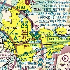
|
CAUTION: Diagram may not be current
 Download PDF
of official airport diagram from the FAA
| Airport distance calculator |
|---|
|
|
| Sunrise and sunset |
|---|
|
Times for 23-Apr-2024
| | Local
(UTC-7) | | Zulu
(UTC) |
|---|
| Morning civil twilight | | 05:11 | | 12:11 |
| Sunrise | | 05:45 | | 12:45 |
| Sunset | | 19:50 | | 02:50 |
| Evening civil twilight | | 20:24 | | 03:24 |
|
| Current date and time |
|---|
| Zulu (UTC) | 23-Apr-2024 21:51:54 |
|---|
| Local (UTC-7) | 23-Apr-2024 14:51:54 |
|---|
|
| METAR |
|---|
| KSFF | 232053Z 17003KT 10SM CLR 18/M04 A2997 RMK AO2 SLP150 T01831044 56013
|
KGEG
9nm SW | 232053Z 00000KT 10SM FEW200 BKN250 18/M06 A2998 RMK AO2 SLP151 T01781056 56011
|
KSKA
14nm W | 232055Z 17005KT 10SM SCT180 16/M05 A2997 RMK AO2A SLP150 T01621050 57010 $
|
KDEW
18nm N | 232053Z AUTO 23009KT 10SM CLR 18/M05 A2997 RMK AO2 SLP153 T01781050 56013
|
|
| TAF |
|---|
| KSFF | 231734Z 2318/2418 VRB03KT P6SM SCT250 FM232000 21004KT P6SM BKN200
|
KGEG
9nm SW | 231734Z 2318/2418 06006KT P6SM SCT250 FM232300 23005KT P6SM BKN200 FM240900 17004KT P6SM FEW150 SCT250 FM241700 21007KT P6SM BKN200
|
KSKA
14nm W | 231900Z 2319/2501 VRB06KT 9999 FEW120 FEW200 QNH2989INS BECMG 2415/2416 22009KT 9999 BKN150 QNH2991INS BECMG 2420/2421 24012G18KT 9999 BKN090 620903 QNH2986INS TX15/2321Z TN01/2412Z
|
|
| NOTAMs |
|---|
NOTAMs are issued by the DoD/FAA and will open in a separate window not controlled by AirNav.
|
|


