FAA INFORMATION EFFECTIVE 21 MARCH 2024
Location
| FAA Identifier: | TOL |
| Lat/Long: | 41-35-12.5400N 083-48-28.1760W
41-35.209000N 083-48.469600W
41.5868167,-83.8078267
(estimated) |
| Elevation: | 683.9 ft. / 208.5 m (surveyed) |
| Variation: | 05W (1990) |
| From city: | 10 miles SW of TOLEDO, OH |
| Time zone: | UTC -4 (UTC -5 during Standard Time) |
| Zip code: | 43558 |
Airport Operations
| Airport use: | Open to the public |
| Activation date: | 01/1955 |
| Control tower: | yes |
| ARTCC: | CLEVELAND CENTER |
| FSS: | CLEVELAND FLIGHT SERVICE STATION |
| NOTAMs facility: | TOL (NOTAM-D service available) |
| Attendance: | CONTINUOUS |
| Wind indicator: | lighted |
| Segmented circle: | no |
| Lights: | SS-SR |
| Beacon: | white-green (lighted land airport)
Operates sunset to sunrise. |
| Landing fee: | yes |
| Fire and rescue: | ARFF index B |
| Airline operations: | 48 HR PPR FOR UNSKED ACR OPS GTR THAN 10 PAX SEATS - CALL AMGR. |
| International operations: | customs landing rights airport |
Airport Communications
| UNICOM: | 122.95 |
| ATIS: | 118.75 290.225 |
| WX ASOS: | PHONE 419-865-6924 |
| TOLEDO GROUND: | 121.9 348.6 |
| TOLEDO TOWER: | 118.1 285.4 |
| TOLEDO APPROACH: | 126.1 ;360-179 134.35 ;180-359 307.0 ;360-179 317.55 ;180-359 123.975 |
| TOLEDO DEPARTURE: | 126.1 ;360-179 134.35 ;180-359 307.0 ;360-179 317.55 ;180-359 123.975 |
| CLEARANCE DELIVERY: | 121.75 348.6 |
| CLASS C: | 126.1 ;360-179 134.35 ;180-359 307.0 ;360-179 317.55 ;180-359 |
| EMERG: | 121.5 243.0 |
| IC: | 134.35 ;180-359 317.55 ;180-359 |
| WX AWOS-3 at DUH (11 nm NE): | 119.175 (734-856-1563) |
| WX AWOS-3 at 1G0 (14 nm SE): | 120.725 (419-354-1415) |
| WX AWOS-3P at USE (14 nm W): | 127.375 (419-335-0775) |
| WX ASOS at TDZ (15 nm E): | 121.575 (419-838-5034) |
Nearby radio navigation aids
| VOR radial/distance | | VOR name | | Freq | | Var |
|---|
| CRLr213/31.8 | | CARLETON VOR/DME | | 115.70 | | 03W |
| FBCr358/38.0 | | FLAG CITY VORTAC | | 108.20 | | 02W |
| NDB name | | Hdg/Dist | | Freq | | Var | | ID |
|---|
| TOPHR | | 074/5.5 | | 219 | | 05W | | TO | - --- |
| ADRIAN | | 151/20.8 | | 278 | | 06W | | ADG | .- -.. --. |
| TECUMSEH | | 179/27.1 | | 239 | | 06W | | TCU | - -.-. ..- |
| TIFFIN | | 323/39.8 | | 269 | | 05W | | TII | - .. .. |
Airport Services
| Fuel available: | 100LL JET-A JET-A++ |
| Parking: | hangars and tiedowns |
| Airframe service: | MAJOR |
| Powerplant service: | MAJOR |
| Bottled oxygen: | HIGH |
| Bulk oxygen: | NONE |
Runway Information
Runway 7/25
| Dimensions: | 10600 x 150 ft. / 3231 x 46 m |
| Surface: | asphalt/grooved, in good condition |
| Weight bearing capacity: | | PCN 67 /F/B/W/T | | Single wheel: | 100.0 | | Double wheel: | 174.0 | | Double tandem: | 300.0 | | Dual double tandem: | 550.0 |
|
| Runway edge lights: | high intensity |
| RUNWAY 7 | | RUNWAY 25 |
| Latitude: | 41-34.883207N | | 41-35.560332N |
| Longitude: | 083-49.842040W | | 083-47.699432W |
| Elevation: | 682.5 ft. | | 664.9 ft. |
| Traffic pattern: | left | | left |
| Runway heading: | 072 magnetic, 067 true | | 252 magnetic, 247 true |
| Declared distances: | TORA:10599 TODA:10599 ASDA:10599 LDA:10599 | | TORA:10599 TODA:10599 ASDA:10599 LDA:10599 |
| Markings: | precision, in good condition | | precision, in good condition |
| Visual slope indicator: | | | 4-light PAPI on left (3.00 degrees glide path)
PAPI UNUSBL BYD 8 DEGS RIGHT OF CNTRLN. |
| RVR equipment: | touchdown, rollout | | touchdown, rollout |
| Approach lights: | ALSF2: standard 2,400 foot high intensity approach lighting system with centerline sequenced flashers (category II or III) | | MALSR: 1,400 foot medium intensity approach lighting system with runway alignment indicator lights |
| Runway end identifier lights: | no | | no |
| Centerline lights: | yes | | yes |
| Touchdown point: | yes, lighted | | yes, no lights |
| Instrument approach: | ILS | | ILS/DME |
| Obstructions: | 91 ft. trees, 4400 ft. from runway, 1000 ft. right of centerline, 46:1 slope to clear | | 75 ft. trees, 2600 ft. from runway, 760 ft. left of centerline, 32:1 slope to clear |
Runway 16/34
| Dimensions: | 5599 x 150 ft. / 1707 x 46 m |
| Surface: | asphalt/grooved, in good condition |
| Weight bearing capacity: | | PCN 52 /F/B/W/T | | Single wheel: | 100.0 | | Double wheel: | 174.0 | | Double tandem: | 300.0 |
|
| Runway edge lights: | medium intensity |
| RUNWAY 16 | | RUNWAY 34 |
| Latitude: | 41-35.609478N | | 41-34.759738N |
| Longitude: | 083-48.137403W | | 083-47.661250W |
| Elevation: | 674.2 ft. | | 664.7 ft. |
| Traffic pattern: | left | | left |
| Runway heading: | 162 magnetic, 157 true | | 342 magnetic, 337 true |
| Declared distances: | TORA:5599 TODA:5599 ASDA:5599 LDA:5599 | | TORA:5599 TODA:5599 ASDA:5599 LDA:5599 |
| Markings: | nonprecision, in good condition | | nonprecision, in good condition |
| Visual slope indicator: | 4-light PAPI on left (3.00 degrees glide path) | | 4-light PAPI on left (3.00 degrees glide path) |
| Runway end identifier lights: | yes | | yes |
| Touchdown point: | yes, no lights | | yes, no lights |
| Obstructions: | 95 ft. trees, 2740 ft. from runway, 40 ft. right of centerline, 26:1 slope to clear | | none |
Airport Ownership and Management from official FAA records
| Ownership: | Publicly-owned |
| Owner: | TOLEDO LUCAS COUNTY PORT AUTHORITY
11013 AIRPORT HWY
SWANTON, OH 43558-9321
Phone 419-865-2351 |
| Manager: | TIM O'DONNELL
11013 AIRPORT HWY
SWANTON, OH 43558-9321
Phone 567-703-8631 |
Airport Operational Statistics
| Aircraft based on the field: | | 80 | | Single engine airplanes: | | 27 | | Multi engine airplanes: | | 10 | | Jet airplanes: | | 19 | | Helicopters: | | 3 | | Military aircraft: | | 21 |
| |  | |
| Aircraft operations: avg 94/day * | | 46% | transient general aviation | | 18% | air taxi | | 14% | local general aviation | | 12% | commercial | | 11% | military | | * for 12-month period ending 31 December 2022 | |
Additional Remarks
| E60-25 | BAK-14 BAK-12B(B) (1050 FT). |
| E60-07 | BAK-14 BAK-12B(B) (1500 FT). |
| - | MILITARY: ANG: TWY D INT TWY D1, HVY ACFT USE MNM PWR TO RDC FOD ON ANG RAMP; FOR QNS CTC COMMAND POST OR AIRFIELD OPS ON 338.15. |
| - | ATIS RECEPTION INTMT 270-320 DEGS, BYD 35 NM. |
| - | MILITARY: ANG: AIRFIELD MGMT DOES NOT ISSUE/STORE COMSEC; FOR COMSEC STORAGE CTC COMMAND POST DSN 580-4035. |
| - | MILITARY: ANG: BIRD HAZ WILDLIFE ACT DURG MIGRATION; BASH PHASE II IN EFF MAR-MAY & AUG-OCT. NSTD BLACK/YELLOW EQPT TOOL BOX LCTN PAINTED ON ANG RAMP. |
| - | CUST: SAT-SUN REQ MUST BE MADE BFR 1700 FRI - CALL 419-732-4446. |
| - | BIRDS ON & INVOF ARPT. |
| - | TWY N3 & RAMP BTN TWY B9 & B13 NOT VSB FM ATCT. |
| - | MILITARY: ANG: PPR - OFFL BUS, ACFT WITH WINGSPANS GTR THAN 75 FT CAN EXP PRKG ON TWY D OR THE SOUTH CARGO RAMP, CTC AIRFIELD OPS DSN 580-4084/4036, C800-495-4250 EXTN 868-4084/868-4036 OR 180.FW.AIRFIELD.MANAGEMENT@US.AF.MIL. 180TH COMMAND POST H24 DSN 580-4035. ALL INBD TSNT ACFT CTC COMMAND POST. |
Instrument Procedures
NOTE: All procedures below are presented as PDF files. If you need a reader for these files, you should download the free Adobe Reader.NOT FOR NAVIGATION. Please procure official charts for flight.
FAA instrument procedures published for use from 21 March 2024 at 0901Z to 18 April 2024 at 0900z.
IAPs - Instrument Approach Procedures |
|---|
| HI-ILS Y OR LOC Y RWY 07 | |
download (139KB) |
| HI-ILS Y OR LOC Y RWY 25 **CHANGED** | |
download (169KB) |
| ILS Z OR LOC Z RWY 07 | |
download (234KB) |
| ILS Z OR LOC Z RWY 25 | |
download (254KB) |
| RNAV (GPS) RWY 07 | |
download (235KB) |
| RNAV (GPS) RWY 16 | |
download (205KB) |
| RNAV (GPS) RWY 25 | |
download (258KB) |
| RNAV (GPS) RWY 34 | |
download (210KB) |
| HI-TACAN RWY 07 **CHANGED** | |
download (144KB) |
| HI-TACAN RWY 25 **CHANGED** | |
download (150KB) |
| Radar Approach Procedures available | |
download (157KB) |
| NOTE: Special Alternate Minimums apply | |
download (169KB) |
| NOTE: Special Take-Off Minimums/Departure Procedures apply | |
download (506KB) |
Other nearby airports with instrument procedures:
KDUH - Toledo Suburban Airport (11 nm NE)
1G0 - Wood County Airport (14 nm SE)
KUSE - Fulton County Airport (14 nm W)
KTDZ - Toledo Executive Airport (15 nm E)
7W5 - Henry County Airport (17 nm SW)
|
|

Road maps at:
MapQuest
Bing
Google
| Aerial photo |
|---|
WARNING: Photo may not be current or correct
 Photo courtesy of AirNav, LLC
Photo taken 21-Jul-2010
Photo courtesy of AirNav, LLC
Photo taken 21-Jul-2010
Do you have a better or more recent aerial photo of Eugene F Kranz Toledo Express Airport that you would like to share? If so, please send us your photo.
|
| Sectional chart |
|---|
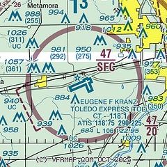
|
 Download PDF
of official airport diagram from the FAA
| Airport distance calculator |
|---|
|
|
| Sunrise and sunset |
|---|
|
Times for 18-Apr-2024
| | Local
(UTC-4) | | Zulu
(UTC) |
|---|
| Morning civil twilight | | 06:21 | | 10:21 |
| Sunrise | | 06:50 | | 10:50 |
| Sunset | | 20:19 | | 00:19 |
| Evening civil twilight | | 20:48 | | 00:48 |
|
| Current date and time |
|---|
| Zulu (UTC) | 18-Apr-2024 04:02:51 |
|---|
| Local (UTC-4) | 18-Apr-2024 00:02:51 |
|---|
|
| METAR |
|---|
| KTOL | 180352Z 25014KT 10SM OVC030 16/09 A2988 RMK AO2 PK WND 28026/0311 SLP115 T01560094
|
KDUH
11nm NE | 180355Z AUTO 27007G14KT 10SM BKN036 BKN044 OVC065 15/10 A2987 RMK AO2 T01480095
|
KUSE
14nm W | 180355Z AUTO 26013KT 10SM FEW030 FEW037 OVC049 14/10 A2988 RMK AO2
|
KTDZ
15nm E | 180353Z AUTO 26013G19KT 10SM BKN060 16/09 A2988 RMK AO2 SLP117 T01610089
|
|
| TAF |
|---|
| KTOL | 180132Z 1802/1824 27012KT P6SM SCT100 FM180800 28012KT P6SM BKN025 FM181600 27009KT P6SM SCT130 FM182200 18006KT P6SM BKN140
|
|
| NOTAMs |
|---|
NOTAMs are issued by the DoD/FAA and will open in a separate window not controlled by AirNav.
|
|


