FAA INFORMATION EFFECTIVE 18 APRIL 2024
Location
| FAA Identifier: | ULS |
| Lat/Long: | 37-36-14.4000N 101-22-24.8000W
37-36.240000N 101-22.413333W
37.6040000,-101.3735556
(estimated) |
| Elevation: | 3071 ft. / 936.0 m (surveyed) |
| Variation: | 06E (2020) |
| From city: | 1 mile N of ULYSSES, KS |
| Time zone: | UTC -5 (UTC -6 during Standard Time) |
| Zip code: | 67880 |
Airport Operations
| Airport use: | Open to the public |
| Activation date: | 02/1947 |
| Control tower: | no |
| ARTCC: | KANSAS CITY CENTER |
| FSS: | WICHITA FLIGHT SERVICE STATION |
| NOTAMs facility: | ICT (NOTAM-D service available) |
| Attendance: | MON-SAT 0800-1800 |
| Wind indicator: | yes |
| Segmented circle: | no |
| Lights: | RYS 12/30 & 17/35 MIRL PRESET ON LOW INTST DUSK-2200; TO INCR INTST & ACTVT AFTER 2200 & PAPI RYS 12, 30, 17 & 35 & TWY A - CTAF. |
| Beacon: | white-green (lighted land airport)
Operates sunset to sunrise. |
Airport Communications
| CTAF/UNICOM: | 122.8 |
| WX AWOS-3PT: | 118.95 (620-424-3747) |
| WX AWOS-3PT at JHN (17 nm W): | 124.175 (620-492-2100) |
- APCH/DEP CTL SVC PRVDD BY KANSAS CITY ARTCC (ZKC) ON 125.2/285.425 (GARDEN CITY RCAG).
Nearby radio navigation aids
| VOR radial/distance | | VOR name | | Freq | | Var |
|---|
| GCKr227/36.1 | | GARDEN CITY VORTAC | | 113.30 | | 11E |
Airport Services
| Fuel available: | 100LL JET-A |
| Parking: | hangars and tiedowns |
| Airframe service: | MAJOR |
| Powerplant service: | MAJOR |
| Bottled oxygen: | NONE |
| Bulk oxygen: | NONE |
Runway Information
Runway 17/35
| Dimensions: | 6000 x 100 ft. / 1829 x 30 m |
| Surface: | concrete, in good condition |
| Weight bearing capacity: | | PCN 19 /R/C/X/U | | Single wheel: | 45.0 | | Double wheel: | 60.0 |
|
| Runway edge lights: | medium intensity |
| RUNWAY 17 | | RUNWAY 35 |
| Latitude: | 37-36.972123N | | 37-35.983630N |
| Longitude: | 101-22.430398W | | 101-22.421182W |
| Elevation: | 3065.3 ft. | | 3060.3 ft. |
| Traffic pattern: | left | | left |
| Runway heading: | 174 magnetic, 180 true | | 354 magnetic, 360 true |
| Markings: | nonprecision, in good condition | | nonprecision, in good condition |
| Visual slope indicator: | 4-light PAPI on left (3.00 degrees glide path) | | 4-light PAPI on left (3.00 degrees glide path) |
| Runway end identifier lights: | no | | no |
| Touchdown point: | yes, no lights | | yes, no lights |
| Obstructions: | 40 ft. pline, 1400 ft. from runway, 30:1 slope to clear | | none |
Runway 12/30
| Dimensions: | 4600 x 60 ft. / 1402 x 18 m |
| Surface: | concrete, in good condition |
| Weight bearing capacity: | | PCN 7 /R/C/X/U | | Single wheel: | 12.5 |
|
| Runway edge lights: | medium intensity |
| RUNWAY 12 | | RUNWAY 30 |
| Latitude: | 37-36.172623N | | 37-35.688892N |
| Longitude: | 101-22.764853W | | 101-22.031525W |
| Elevation: | 3071.0 ft. | | 3061.9 ft. |
| Traffic pattern: | left | | left |
| Runway heading: | 124 magnetic, 130 true | | 304 magnetic, 310 true |
| Markings: | nonprecision, in good condition | | nonprecision, in good condition |
| Visual slope indicator: | 2-light PAPI on left (3.00 degrees glide path) | | 2-light PAPI on left (3.00 degrees glide path) |
| Touchdown point: | yes, no lights | | yes, no lights |
| Obstructions: | 16 ft. road, 700 ft. from runway, 30:1 slope to clear | | none |
Airport Ownership and Management from official FAA records
| Ownership: | Publicly-owned |
| Owner: | GRANT COUNTY
108 S GLENN
ULYSSES, KS 67880
Phone 620-356-1335 |
| Manager: | STEVE RICE
PO BOX 412
ULYSSES, KS 67880
Phone 620-952-0954
DARREN FIGGINS CHMN ARPT BOARD PHONE 620-353-4137 & STEVE RICE NORTH STAR AVN INC; FBO 620-356-4528. |
Airport Operational Statistics
| Aircraft based on the field: | | 36 | | Single engine airplanes: | | 26 | | Multi engine airplanes: | | 5 | | Helicopters: | | 1 | | Gliders airplanes: | | 4 |
| |  | |
| Aircraft operations: avg 59/day * | | 70% | local general aviation | | 28% | transient general aviation | | 2% | air taxi | | * for 12-month period ending 28 August 2019 | |
Additional Remarks
| - | PUBLIC PHONE AVBL 24 HRS 620-356-9306. |
| - | GLIDER & ULTRA LIGHT ACTIVITY ON & INVOF ARPT. |
| - | TWY A PARALLEL TO RY 17/35. |
| - | FOR CD IF UNA TO CTC ON FSS FREQ, CTC KANSAS CITY ARTCC AT 913-254-8508. |
Instrument Procedures
NOTE: All procedures below are presented as PDF files. If you need a reader for these files, you should download the free Adobe Reader.NOT FOR NAVIGATION. Please procure official charts for flight.
FAA instrument procedures published for use from 18 April 2024 at 0901Z to 16 May 2024 at 0900Z.
IAPs - Instrument Approach Procedures |
|---|
| RNAV (GPS) RWY 12 | |
download (208KB) |
| RNAV (GPS) RWY 17 | |
download (199KB) |
| RNAV (GPS) RWY 30 | |
download (221KB) |
| RNAV (GPS) RWY 35 | |
download (227KB) |
| NOTE: Special Alternate Minimums apply | |
download (146KB) |
| NOTE: Special Take-Off Minimums/Departure Procedures apply | |
download (149KB) |
Other nearby airports with instrument procedures:
KJHN - Stanton County Municipal Airport (17 nm W)
KHQG - Hugoton Municipal Airport (26 nm S)
3K3 - Syracuse-Hamilton County Municipal Airport (30 nm NW)
KGCK - Garden City Regional Airport (36 nm NE)
KLBL - Liberal Mid-America Regional Airport (39 nm SE)
|
|

Road maps at:
MapQuest
Bing
Google
| Aerial photo |
|---|
WARNING: Photo may not be current or correct
 Photo taken 07-Sep-2007
Do you have a better or more recent aerial photo of Ulysses Airport that you would like to share? If so, please send us your photo.
|
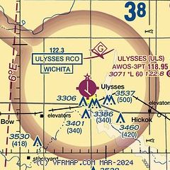
| Sectional chart |
|---|
|
| Airport distance calculator |
|---|
|
|
| Sunrise and sunset |
|---|
|
Times for 20-Apr-2024
| | Local
(UTC-5) | | Zulu
(UTC) |
|---|
| Morning civil twilight | | 06:36 | | 11:36 |
| Sunrise | | 07:03 | | 12:03 |
| Sunset | | 20:25 | | 01:25 |
| Evening civil twilight | | 20:53 | | 01:53 |
|
| Current date and time |
|---|
| Zulu (UTC) | 20-Apr-2024 07:42:39 |
|---|
| Local (UTC-5) | 20-Apr-2024 02:42:39 |
|---|
|
| METAR |
|---|
| KULS | 200715Z AUTO 05009KT 10SM FEW025 OVC070 06/M01 A3031 RMK AO2
|
KJHN
17nm W | 200715Z AUTO 05010KT 10SM OVC075 06/M02 A3030 RMK AO2 T00561022
|
|
| TAF |
|---|
KGCK
36nm NE | 200536Z 2006/2106 05010KT P6SM OVC070 TEMPO 2012/2014 4SM -RA BKN025 FM201400 06011G17KT P6SM OVC030
|
KLBL
39nm SE | 200536Z 2006/2106 05010KT P6SM BKN100 FM201700 08012KT P6SM OVC070
|
|
| NOTAMs |
|---|
NOTAMs are issued by the DoD/FAA and will open in a separate window not controlled by AirNav.
|
|


