FAA INFORMATION EFFECTIVE 18 APRIL 2024
Location
| FAA Identifier: | USE |
| Lat/Long: | 41-36-35.2029N 084-07-37.8788W
41-36.586715N 084-07.631313W
41.6097786,-84.1271886
(estimated) |
| Elevation: | 780.8 ft. / 238.0 m (surveyed) |
| Variation: | 05W (1995) |
| From city: | 4 miles N of WAUSEON, OH |
| Time zone: | UTC -4 (UTC -5 during Standard Time) |
| Zip code: | 43567 |
Airport Operations
| Airport use: | Open to the public |
| Control tower: | no |
| ARTCC: | CLEVELAND CENTER |
| FSS: | CLEVELAND FLIGHT SERVICE STATION |
| NOTAMs facility: | USE (NOTAM-D service available) |
| Attendance: | MON-SAT 0800-1700
FOR SVC AFT HRS CALL AMGR. |
| Wind indicator: | lighted |
| Segmented circle: | no |
| Lights: | ACTVT REIL RWY 09 & 27; PAPI RWY 09 & 27; MIRL RWY 09/27 - CTAF. |
| Beacon: | white-green (lighted land airport)
Operates sunset to sunrise. |
Airport Communications
| CTAF/UNICOM: | 123.0 |
| WX AWOS-3P: | 127.375 (419-335-0775) |
| TOLEDO APPROACH: | 134.35 |
| TOLEDO DEPARTURE: | 134.35 |
| WX ASOS at TOL (14 nm E): | PHONE 419-865-6924 |
| WX ASOS at ADG (16 nm N): | 118.375 (517-265-9089) |
Nearby radio navigation aids
| VOR radial/distance | | VOR name | | Freq | | Var |
|---|
| CRLr232/39.8 | | CARLETON VOR/DME | | 115.70 | | 03W |
| NDB name | | Hdg/Dist | | Freq | | Var | | ID |
|---|
| TOPHR | | 295/9.8 | | 219 | | 05W | | TO | - --- |
| ADRIAN | | 194/15.8 | | 278 | | 06W | | ADG | .- -.. --. |
| TECUMSEH | | 209/27.6 | | 239 | | 06W | | TCU | - -.-. ..- |
Airport Services
| Fuel available: | 100LL JET-A JET-A1+ UL94
100LL:100LL AVBL H24 SELF SVC VIA CREDIT CARD.
A:FOR JET A AFT HRS CALL AMGR.
UL94:UL94 AVBL H24 SELF SVC VIA CREDIT CARD. |
| Parking: | hangars and tiedowns |
| Airframe service: | NONE |
| Powerplant service: | NONE |
Runway Information
Runway 9/27
| Dimensions: | 3882 x 75 ft. / 1183 x 23 m |
| Surface: | asphalt, in good condition |
| Weight bearing capacity: | |
| Runway edge lights: | medium intensity |
| Runway edge markings: | FADED. |
| RUNWAY 9 | | RUNWAY 27 |
| Latitude: | 41-36.615565N | | 41-36.625793N |
| Longitude: | 084-07.957775W | | 084-07.106152W |
| Elevation: | 778.8 ft. | | 770.0 ft. |
| Traffic pattern: | left | | left |
| Runway heading: | 094 magnetic, 089 true | | 274 magnetic, 269 true |
| Markings: | nonprecision, in poor condition | | nonprecision, in poor condition |
| Visual slope indicator: | 4-light PAPI on left (3.00 degrees glide path) | | 4-light PAPI on right (3.00 degrees glide path) |
| Runway end identifier lights: | yes | | yes |
| Touchdown point: | yes, no lights | | yes, no lights |
| Obstructions: | 15 ft. road, 457 ft. from runway, 17:1 slope to clear
+10 FT ACFT RAMP/PRKG, 0-142 FT DIST, 202-250 FT R. | | 70 ft. trees, 1417 ft. from runway, 429 ft. left of centerline, 17:1 slope to clear |
Runway 18/36
| Dimensions: | 2115 x 75 ft. / 645 x 23 m |
| Surface: | asphalt/turf, in good condition
359 FT OF CNTR SECTION ASPH, NORTH 270 FT TURF, SOUTH 1328 FT TURF. |
| RUNWAY 18 | | RUNWAY 36 |
| Latitude: | 41-36.698532N | | 41-36.350215N |
| Longitude: | 084-07.813812W | | 084-07.813517W |
| Elevation: | 777.0 ft. | | 780.6 ft. |
| Traffic pattern: | left | | left |
| Runway heading: | 185 magnetic, 180 true | | 005 magnetic, 360 true |
| Touchdown point: | yes, no lights | | yes, no lights |
| Obstructions: | none | | 67 ft. tree, 1149 ft. from runway, 219 ft. right of centerline, 17:1 slope to clear |
Airport Ownership and Management from official FAA records
| Ownership: | Publicly-owned |
| Owner: | FULTON COUNTY
9460 COUNTY ROAD 14
WAUSEON, OH 43567-9670
Phone 419-337-9255 |
| Manager: | JOHN CRISP
9460 COUNTY ROAD 14
WAUSEON, OH 43567-9670
Phone 419-335-3993
KUSE@FULTONCOUNTYOH.COM. |
Airport Operational Statistics
| Aircraft based on the field: | | 22 | | Single engine airplanes: | | 21 | | Gliders airplanes: | | 1 |
| |  | |
| Aircraft operations: avg 62/day * | | 53% | local general aviation | | 44% | transient general aviation | | 2% | air taxi | | <1% | military | | * for 12-month period ending 30 June 2022 | |
Additional Remarks
| - | DEER ON & INVOF ARPT. |
| - | RESTROOM ACCESS, UNICOM. |
| - | FOR CD CTC TOLEDO APCH AT 419-865-1495. |
| - | RWY 27 CLIMB STRAIGHT OUT TO 1300 MSL. |
Instrument Procedures
NOTE: All procedures below are presented as PDF files. If you need a reader for these files, you should download the free Adobe Reader.NOT FOR NAVIGATION. Please procure official charts for flight.
FAA instrument procedures published for use from 18 April 2024 at 0901Z to 16 May 2024 at 0900Z.
IAPs - Instrument Approach Procedures |
|---|
| RNAV (GPS) RWY 09 | |
download (202KB) |
| RNAV (GPS) RWY 27 | |
download (204KB) |
| NOTE: Special Take-Off Minimums/Departure Procedures apply | |
download (272KB) |
Other nearby airports with instrument procedures:
7W5 - Henry County Airport (14 nm S)
KTOL - Eugene F Kranz Toledo Express Airport (14 nm E)
KADG - Lenawee County Airport (16 nm N)
0G6 - Williams County Airport (19 nm SW)
KDFI - Defiance Memorial Airport (21 nm SW)
|
|

Road maps at:
MapQuest
Bing
Google
| Aerial photo |
|---|
WARNING: Photo may not be current or correct

Do you have a better or more recent aerial photo of Fulton County Airport that you would like to share? If so, please send us your photo.
|
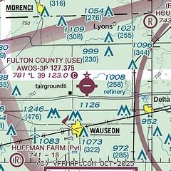
| Sectional chart |
|---|
|
| Airport distance calculator |
|---|
|
|
| Sunrise and sunset |
|---|
|
Times for 19-Apr-2024
| | Local
(UTC-4) | | Zulu
(UTC) |
|---|
| Morning civil twilight | | 06:21 | | 10:21 |
| Sunrise | | 06:50 | | 10:50 |
| Sunset | | 20:21 | | 00:21 |
| Evening civil twilight | | 20:50 | | 00:50 |
|
| Current date and time |
|---|
| Zulu (UTC) | 19-Apr-2024 22:18:33 |
|---|
| Local (UTC-4) | 19-Apr-2024 18:18:33 |
|---|
|
| METAR |
|---|
| KUSE | 192155Z AUTO 28011G21KT 10SM CLR 12/M03 A3002 RMK AO2
|
KTOL
15nm E | 192152Z 27015G25KT 10SM CLR 13/M04 A3002 RMK AO2 PK WND 28028/2101 SLP167 T01331044
|
KADG
16nm N | 192153Z AUTO 30014KT 10SM CLR 13/M04 A3002 RMK AO2 PK WND 28026/2132 SLP170 T01281039
|
|
| TAF |
|---|
KTOL
15nm E | 191731Z 1918/2018 28015G25KT P6SM SCT100 FM201000 28010KT P6SM BKN100 FM201500 28015G25KT P6SM SCT050
|
|
| NOTAMs |
|---|
NOTAMs are issued by the DoD/FAA and will open in a separate window not controlled by AirNav.
|
|

