FAA INFORMATION EFFECTIVE 18 APRIL 2024
Location
| FAA Identifier: | VJI |
| Lat/Long: | 36-41-13.5691N 082-01-59.9761W
36-41.226152N 082-01.999602W
36.6871025,-82.0333267
(estimated) |
| Elevation: | 2087.4 ft. / 636.2 m (surveyed) |
| Variation: | 05W (1995) |
| From city: | 2 miles W of ABINGDON, VA |
| Time zone: | UTC -4 (UTC -5 during Standard Time) |
| Zip code: | 24210 |
Airport Operations
| Airport use: | Open to the public |
| Activation date: | 08/1986 |
| Control tower: | no |
| ARTCC: | ATLANTA CENTER |
| FSS: | LEESBURG FLIGHT SERVICE STATION |
| NOTAMs facility: | VJI (NOTAM-D service available) |
| Attendance: | 1200-0000Z
UNATNDD NEW YEAR'S DAY, JULY 4TH, THANKSGIVING DAY, AND CHRISTMAS DAY. |
| Pattern altitude: | 3077.4 ft. MSL |
| Wind indicator: | lighted |
| Segmented circle: | yes |
| Lights: | ACTVT ODALS RWY 24; REIL RWY 24; PAPI RWY 24; MIRL RWY 06/24 - CTAF. |
| Beacon: | white-green (lighted land airport)
Operates sunset to sunrise. |
Airport Communications
| CTAF/UNICOM: | 122.8 |
| WX AWOS-3: | 128.125 (276-628-2940) |
| TRI CITY APPROACH: | 125.25 |
| TRI CITY DEPARTURE: | 125.25 |
| WX AWOS-3 at 6A4 (19 nm SE): | 126.225 (423-727-4365) |
- APCH/DEP SVC PRVDD BY ATLANTA ARTCC ON FREQS 127.85/269.3 (GLADE SPRINGS RCAG) WHEN TRI CITY APCH CTL CLSD.
Nearby radio navigation aids
| VOR radial/distance | | VOR name | | Freq | | Var |
|---|
| GZGr167/8.6 | | GLADE SPRING VOR/DME | | 115.55 | | 02W |
| HMVr021/15.7 | | HOLSTON MOUNTAIN VORTAC | | 114.60 | | 04W |
| NDB name | | Hdg/Dist | | Freq | | Var | | ID |
|---|
| HEMLOCK | | 349/32.9 | | 320 | | 02W | | BAR | -... .- .-. |
Airport Services
| Fuel available: | 100LL JET-A
A:PRIST, ANTI-ICING FUEL ADDITIVE AVBL.
100LL:FOR FUEL AFT HRS, ARNG BFR 0000Z HRS AT 276-628-6030 OR 276-274-4040. THERE IS A FEE CTC FBO. |
| Parking: | hangars and tiedowns |
| Airframe service: | MAJOR |
| Powerplant service: | MAJOR |
| Bottled oxygen: | NONE |
| Bulk oxygen: | NONE |
Runway Information
Runway 6/24
| Dimensions: | 4471 x 75 ft. / 1363 x 23 m |
| Surface: | asphalt, in fair condition |
| Weight bearing capacity: | |
| Runway edge lights: | medium intensity |
| RUNWAY 6 | | RUNWAY 24 |
| Latitude: | 36-41.020350N | | 36-41.431953N |
| Longitude: | 082-02.378883W | | 082-01.620320W |
| Elevation: | 2062.6 ft. | | 2087.4 ft. |
| Traffic pattern: | left | | left |
| Runway heading: | 061 magnetic, 056 true | | 241 magnetic, 236 true |
| Markings: | nonprecision, in fair condition | | nonprecision, in fair condition |
| Visual slope indicator: | | | 2-light PAPI on left (4.00 degrees glide path) |
| Approach lights: | | | ODALS: omnidirectional approach lighting system |
| Runway end identifier lights: | | | yes |
| Touchdown point: | yes, no lights | | yes, no lights |
| Instrument approach: | | | LOC/DME |
| Obstructions: | 151 ft. tree, 4032 ft. from runway, 255 ft. left of centerline, 25:1 slope to clear | | 81 ft. tree, 2166 ft. from runway, 429 ft. right of centerline, 24:1 slope to clear |
Airport Ownership and Management from official FAA records
| Ownership: | Publicly-owned |
| Owner: | VA HIGHLANDS ARPT AUTHORITY
PO BOX 631
ABINGDON, VA 24212
Phone 276-628-2909 |
| Manager: | MICKEY HINES
PO BOX 631
ABINGDON, VA 24212
Phone 276-628-2909 |
Airport Operational Statistics
| Aircraft based on the field: | | 57 | | Single engine airplanes: | | 38 | | Multi engine airplanes: | | 9 | | Jet airplanes: | | 6 | | Helicopters: | | 4 |
- ULTRALIGHTS ON & INVOF ARPT.
| |  | |
| Aircraft operations: avg 84/day * | | 46% | transient general aviation | | 44% | local general aviation | | 9% | air taxi | | 1% | military | | * for 12-month period ending 31 July 2023 | |
Additional Remarks
| - | WILDLIFE INVOF ARPT. |
| - | WHEN TRI CITIES APCH CLSD, FOR CD CTC ATLANTA ARTCC AT 770-210-7692. |
Instrument Procedures
NOTE: All procedures below are presented as PDF files. If you need a reader for these files, you should download the free Adobe Reader.NOT FOR NAVIGATION. Please procure official charts for flight.
FAA instrument procedures published for use from 18 April 2024 at 0901Z to 16 May 2024 at 0900Z.
IAPs - Instrument Approach Procedures |
|---|
| RNAV (GPS) RWY 06 | |
download (209KB) |
| RNAV (GPS) RWY 24 | |
download (249KB) |
| LOC RWY 24 **CHANGED** | |
download (296KB) |
| NOTE: Special Alternate Minimums apply | |
download (157KB) |
| NOTE: Special Take-Off Minimums/Departure Procedures apply | |
download (140KB) |
Other nearby airports with instrument procedures:
6A4 - Johnson County Airport (19 nm SE)
0A9 - Elizabethton Municipal Airport (20 nm S)
KTRI - Tri-Cities Airport (22 nm SW)
KJFZ - Tazewell County Airport (25 nm NE)
KLNP - Lonesome Pine Airport (30 nm NW)
|
|

Road maps at:
MapQuest
Bing
Google
| Aerial photo |
|---|
WARNING: Photo may not be current or correct
 Taken in December 2005
Do you have a better or more recent aerial photo of Virginia Highlands Airport that you would like to share? If so, please send us your photo.
|
| Sectional chart |
|---|
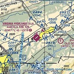
|
| Airport distance calculator |
|---|
|
|
| Sunrise and sunset |
|---|
|
Times for 18-Apr-2024
| | Local
(UTC-4) | | Zulu
(UTC) |
|---|
| Morning civil twilight | | 06:23 | | 10:23 |
| Sunrise | | 06:50 | | 10:50 |
| Sunset | | 20:05 | | 00:05 |
| Evening civil twilight | | 20:32 | | 00:32 |
|
| Current date and time |
|---|
| Zulu (UTC) | 18-Apr-2024 21:05:56 |
|---|
| Local (UTC-4) | 18-Apr-2024 17:05:56 |
|---|
|
| METAR |
|---|
| KVJI | 182055Z AUTO 24010KT 10SM CLR 25/12 A3007 RMK AO2 T02490121
|
|
| TAF |
|---|
KTRI
21nm SW | 181734Z 1818/1918 22004KT P6SM FEW250 FM190900 VRB03KT P6SM -SHRA SCT025 OVC060 FM191400 23004KT P6SM OVC025
|
|
| NOTAMs |
|---|
NOTAMs are issued by the DoD/FAA and will open in a separate window not controlled by AirNav.
|
|


