FAA INFORMATION EFFECTIVE 18 APRIL 2024
Location
| FAA Identifier: | X59 |
| Lat/Long: | 27-57-39.1160N 080-33-29.9800W
27-57.651933N 080-33.499667W
27.9608656,-80.5583278
(estimated) |
| Elevation: | 25.8 ft. / 7.9 m (surveyed) |
| Variation: | 03W (1985) |
| From city: | 1 mile W of VALKARIA, FL |
| Time zone: | UTC -4 (UTC -5 during Standard Time) |
| Zip code: | 32950 |
Airport Operations
| Airport use: | Open to the public |
| Activation date: | 12/1946 |
| Control tower: | no |
| ARTCC: | JACKSONVILLE CENTER |
| FSS: | SAINT PETERSBURG FLIGHT SERVICE STATION |
| NOTAMs facility: | PIE (NOTAM-D service available) |
| Attendance: | MON-FRI 0800-1700 |
| Wind indicator: | lighted |
| Segmented circle: | yes |
| Lights: | APLG NOT OPR DURG DALGT HOURS. SS-SR, ACTVT MIRL 14/32- CTAF. |
| Beacon: | white-green (lighted land airport)
Operates sunset to sunrise. |
Airport Communications
| CTAF/UNICOM: | 122.725 |
| WX AWOS-3PT: | 119.525 |
| WX AWOS-3PT at X26 (9 nm S): | 118.125 (772-228-7020) |
| WX ASOS at MLB (10 nm NW): | 132.55 (321-951-7575) |
| WX ASOS at VRB (20 nm S): | 120.575 (772-978-9535) |
Nearby radio navigation aids
| VOR radial/distance | | VOR name | | Freq | | Var |
|---|
| MLBr162/9.6 | | MELBOURNE VOR/DME | | 115.85 | | 07W |
| TRVr355/17.3 | | TREASURE VORTAC | | 117.30 | | 07W |
Airport Services
| Fuel available: | 100LL |
| Parking: | tiedowns |
| Airframe service: | MAJOR |
| Powerplant service: | MAJOR |
| Bottled oxygen: | NONE |
| Bulk oxygen: | NONE |
Runway Information
Runway 10/28
| Dimensions: | 4000 x 75 ft. / 1219 x 23 m |
| Surface: | asphalt, in fair condition |
| Weight bearing capacity: | | PCN 6 /F/B/Y/T | | Single wheel: | 12.5 |
|
| RUNWAY 10 | | RUNWAY 28 |
| Latitude: | 27-57.574833N | | 27-57.572667N |
| Longitude: | 080-33.947167W | | 080-33.203500W |
| Elevation: | 23.5 ft. | | 25.7 ft. |
| Traffic pattern: | left | | left |
| Markings: | basic, in fair condition | | basic, in fair condition |
| Visual slope indicator: | | | 4-light PAPI on right (3.00 degrees glide path) |
| Touchdown point: | yes, no lights | | yes, no lights |
| Obstructions: | 27 ft. trees, 530 ft. from runway, 120 ft. right of centerline, 12:1 slope to clear | | 17 ft. trees, 330 ft. from runway, 105 ft. right of centerline, 7:1 slope to clear |
Runway 14/32
| Dimensions: | 4000 x 75 ft. / 1219 x 23 m |
| Surface: | asphalt, in excellent condition |
| Weight bearing capacity: | | PCN 8 /F/A/Y/T | | Single wheel: | 12.5 |
|
| Runway edge lights: | medium intensity |
| RUNWAY 14 | | RUNWAY 32 |
| Latitude: | 27-57.974538N | | 27-57.485717N |
| Longitude: | 080-33.673700W | | 080-33.174217W |
| Elevation: | 24.6 ft. | | 24.2 ft. |
| Traffic pattern: | left | | left |
| Markings: | nonprecision, in good condition | | nonprecision, in good condition |
| Visual slope indicator: | 4-light PAPI on right (3.00 degrees glide path) | | 4-light PAPI on left (3.00 degrees glide path) |
| Touchdown point: | yes, no lights | | yes, no lights |
| Obstructions: | 27 ft. trees, 635 ft. from runway, 70 ft. right of centerline, 16:1 slope to clear | | 24 ft. trees, 470 ft. from runway, 60 ft. left of centerline, 11:1 slope to clear |
Airport Ownership and Management from official FAA records
| Ownership: | Publicly-owned |
| Owner: | BREVARD COUNTY
2725 JUDGE FRAN JAMIESON WAY, BUILDING C SUITE 301
VIERA, FL 32940
Phone (321) 633-2001 |
| Manager: | PHILLIP HIED
1 PILOT'S PLACE
VALKARIA, FL 32950
Phone 321-952-4590
PHILLIP HIED |
Airport Operational Statistics
| Aircraft based on the field: | | 113 | | Single engine airplanes: | | 97 | | Multi engine airplanes: | | 3 | | Helicopters: | | 5 | | Gliders airplanes: | | 2 | | Ultralights: | | 6 |
| |  | |
| Aircraft operations: avg 207/day * | | 79% | local general aviation | | 20% | transient general aviation | | 1% | military | | * for 12-month period ending 15 March 2022 | |
Additional Remarks
| - | POWERED PARAGLIDER OPERATIONS. |
| - | FOR CD OR TO CNL IFR CTC ORLANDO APCH AT 407-852-7500. |
| - | AWOS 119.525 |
| - | TSNT GATE CODE C1467Z. |
Instrument Procedures
There are no published instrument procedures at X59.
Some nearby airports with instrument procedures:
X26 - Sebastian Municipal Airport (9 nm S)
KMLB - Melbourne Orlando International Airport (10 nm NW)
KCOF - Patrick Space Force Base Airport (17 nm N)
KVRB - Vero Beach Regional Airport (20 nm S)
KCOI - Merritt Island Airport (24 nm N)
|
|

Road maps at:
MapQuest
Bing
Google
| Aerial photo |
|---|
WARNING: Photo may not be current or correct
 Photo by Lance Jackson
looking southeast
Photo by Lance Jackson
looking southeast
Do you have a better or more recent aerial photo of Valkaria Airport that you would like to share? If so, please send us your photo.
|
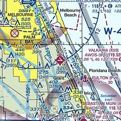
| Sectional chart |
|---|
|
| Airport distance calculator |
|---|
|
|
| Sunrise and sunset |
|---|
|
Times for 20-Apr-2024
| | Local
(UTC-4) | | Zulu
(UTC) |
|---|
| Morning civil twilight | | 06:28 | | 10:28 |
| Sunrise | | 06:52 | | 10:52 |
| Sunset | | 19:50 | | 23:50 |
| Evening civil twilight | | 20:14 | | 00:14 |
|
| Current date and time |
|---|
| Zulu (UTC) | 20-Apr-2024 11:33:35 |
|---|
| Local (UTC-4) | 20-Apr-2024 07:33:35 |
|---|
|
| METAR |
|---|
KX26
9nm S | 201115Z AUTO 00000KT 10SM CLR 18/18 A3007 RMK AO2 T01850178
|
KMLB
10nm NW | 201053Z 30003KT 10SM CLR 19/18 A3006 RMK AO2 SLP178 T01890178
|
KCOF
15nm N | 201055Z AUTO 26003KT 10SM CLR 20/18 A3003 RMK AO2 SLP174 T02040183 $
|
|
| TAF |
|---|
KMLB
10nm NW | 200520Z 2006/2106 VRB05KT P6SM SKC FM201700 09012KT P6SM FEW050 FM202300 15010KT P6SM FEW060 FEW250 FM210300 VRB05KT P6SM FEW150 SCT250
|
KCOF
15nm N | 191130Z 1911/2016 21006KT 9999 SCT040 QNH3000INS BECMG 1916/1917 13010G15KT 9999 FEW040 QNH2998INS BECMG 2003/2004 VRB06KT 9999 FEW040 QNH3003INS TX28/1918Z TN22/1911Z LAST NO AMDS AFT 1912 NEXT 2210
|
|
| NOTAMs |
|---|
NOTAMs are issued by the DoD/FAA and will open in a separate window not controlled by AirNav.
|
|


