FAA INFORMATION EFFECTIVE 18 APRIL 2024
Location
| FAA Identifier: | Y94 |
| Lat/Long: | 45-07-48.6621N 085-06-24.5340W
45-07.811035N 085-06.408900W
45.1301839,-85.1068150
(estimated) |
| Elevation: | 641 ft. / 195.4 m (surveyed) |
| Variation: | 05W (1985) |
| From city: | 2 miles SE of EAST JORDAN, MI |
| Time zone: | UTC -4 (UTC -5 during Standard Time) |
| Zip code: | 49727 |
Airport Operations
| Airport use: | Open to the public |
| Activation date: | 08/1945 |
| Control tower: | no |
| ARTCC: | MINNEAPOLIS CENTER |
| FSS: | LANSING FLIGHT SERVICE STATION |
| NOTAMs facility: | LAN (NOTAM-D service available) |
| Attendance: | UNATNDD |
| Wind indicator: | lighted |
| Segmented circle: | yes |
| Lights: | ACTVT VASI RWY 27; MIRL RWY 09/27 - CTAF. |
Airport Communications
| CTAF: | 122.9 |
| WX AWOS-3PT at BFA (8 nm E): | 118.675 (231-330-8677) |
| WX AWOS-3P at ACB (9 nm SW): | 119.275 (231-533-8941) |
| WX AWOS-3P at CVX (13 nm NW): | 120.0 (231-237-9703) |
| WX ASOS at GLR (18 nm E): | 118.375 (989-732-1571) |
| WX AWOS-3P at MGN (20 nm NE): | 119.925 (231-347-5231) |
Nearby radio navigation aids
| VOR radial/distance | | VOR name | | Freq | | Var |
|---|
| GLRr298/18.5 | | GAYLORD VOR/DME | | 109.20 | | 06W |
| CGGr335/(31.4) | | GRAYLING VOR | | 109.80 | | 06W |
| TVCr036/33.5 | | TRAVERSE CITY VOR/DME | | 114.60 | | 02W |
| PLNr218/35.4 | | PELLSTON VORTAC | | 111.80 | | 06W |
| NDB name | | Hdg/Dist | | Freq | | Var | | ID |
|---|
| BANGU | | 305/14.4 | | 375 | | 06W | | GL | --. .-.. |
| GRAYLING | | 339/25.7 | | 359 | | 06W | | GYG | --. -.-- --. |
Airport Services
| Parking: | tiedowns |
| Airframe service: | NONE |
Runway Information
Runway 9/27
| Dimensions: | 3250 x 50 ft. / 991 x 15 m |
| Surface: | asphalt, in fair condition |
| Runway edge lights: | medium intensity |
| RUNWAY 9 | | RUNWAY 27 |
| Latitude: | 45-07.861667N | | 45-07.849333N |
| Longitude: | 085-06.748333W | | 085-05.992833W |
| Elevation: | 630.0 ft. | | 641.0 ft. |
| Traffic pattern: | left | | left |
| Runway heading: | 096 magnetic, 091 true | | 276 magnetic, 271 true |
| Displaced threshold: | no | | 125 ft. |
| Markings: | basic, in fair condition | | basic, in fair condition |
| Visual slope indicator: | | | 2-box VASI on left (4.00 degrees glide path) |
| Obstructions: | none | | 15 ft. road, 231 ft. from runway, 2:1 slope to clear
APCH RATIO 18:1 TO DTHR OVR +80 FT TREES, 1470 FT DIST, 165 FT R. |
Runway 18/36
| Dimensions: | 1800 x 120 ft. / 549 x 37 m |
| Surface: | turf, in fair condition |
| Runway edge markings: | 3 FT YELLOW CONES. |
| Operational restrictions: | CLSD NOV-APR & WHEN SNOW COVD; NO SNOW REMOVAL. |
| RUNWAY 18 | | RUNWAY 36 |
| Latitude: | 45-07.878833N | | 45-07.582667N |
| Longitude: | 085-06.479167W | | 085-06.477000W |
| Elevation: | 635.0 ft. | | 624.0 ft. |
| Traffic pattern: | left | | left |
| Runway heading: | 185 magnetic, 180 true | | 005 magnetic, 360 true |
| Obstructions: | 55 ft. trees, 545 ft. from runway, 198 ft. left of centerline, 9:1 slope to clear
APCH RATIO 16:1 BASED ON STRAIGHT OUT OVR 62 FT TREE, 1036 FT DIST, 0 FT B. | | 37 ft. trees, 125 ft. left of centerline, 1:1 slope to clear |
Airport Ownership and Management from official FAA records
| Ownership: | Publicly-owned |
| Owner: | CITY OF EAST JORDAN
5000 AIRPORT DR, PO BOX 499
EAST JORDAN, MI 49727-0499
Phone 231-536-3381 |
| Manager: | TOM CANNON, CITY MGR
201 MAIN ST
EAST JORDAN, MI 49727
Phone 231-536-3381
CELL 231-357-0646. |
Airport Operational Statistics
| Aircraft based on the field: | | 3 | | Single engine airplanes: | | 3 |
| |  | |
| Aircraft operations: avg 29/week * | | 67% | transient general aviation | | 33% | local general aviation | | * for 12-month period ending 31 December 2021 | |
Additional Remarks
| - | BIRDS & DEER ON & INVOF ARPT. |
| - | 1670 FT MSL TWR 3 MI NE. |
| - | FOR CD CTC MINNEAPOLIS ARTCC AT 651-463-5588. |
Instrument Procedures
There are no published instrument procedures at Y94.
Some nearby airports with instrument procedures:
N98 - Boyne City Municipal Airport (7 nm NE)
KBFA - Boyne Mountain Airport (8 nm E)
KACB - Antrim County Airport (9 nm SW)
KCVX - Charlevoix Municipal Airport (13 nm NW)
KGLR - Gaylord Regional Airport (18 nm E)
KMGN - Harbor Springs Airport (20 nm NE)
|
|

Road maps at:
MapQuest
Bing
Google
| Aerial photo |
|---|
WARNING: Photo may not be current or correct
 Photo by Terrance A Graham, AOPA ASN Volunteer for Y94
Photo taken 30-Sep-2018
looking west.
Photo by Terrance A Graham, AOPA ASN Volunteer for Y94
Photo taken 30-Sep-2018
looking west.
Do you have a better or more recent aerial photo of East Jordan City Airport that you would like to share? If so, please send us your photo.
|
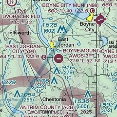
| Sectional chart |
|---|
|
| Airport distance calculator |
|---|
|
|
| Sunrise and sunset |
|---|
|
Times for 25-Apr-2024
| | Local
(UTC-4) | | Zulu
(UTC) |
|---|
| Morning civil twilight | | 06:06 | | 10:06 |
| Sunrise | | 06:38 | | 10:38 |
| Sunset | | 20:38 | | 00:38 |
| Evening civil twilight | | 21:10 | | 01:10 |
|
| Current date and time |
|---|
| Zulu (UTC) | 25-Apr-2024 20:04:19 |
|---|
| Local (UTC-4) | 25-Apr-2024 16:04:19 |
|---|
|
| METAR |
|---|
KBFA
8nm E | 251955Z AUTO 29005G13KT 10SM CLR 13/M10 A3030 RMK AO2
|
KACB
10nm SW | 251955Z AUTO 33003KT 10SM CLR 12/M08 A3031 RMK AO2 T01241081
|
KCVX
12nm NW | 251955Z AUTO 34007KT 10SM CLR 07/M04 A3034 RMK AO2 T00691038
|
KGLR
19nm E | 251953Z AUTO 10SM CLR 12/M10 A3030 RMK AO2 SLP272 T01171100
|
KMGN
20nm NE | 251955Z AUTO 25006KT 10SM CLR 10/M10 A3032 RMK AO2 T01071099
|
|
| TAF |
|---|
KPLN
29nm NE | 251720Z 2518/2618 VRB04KT P6SM SKC FM261500 14015KT P6SM SKC
|
KTVC
31nm SW | 251720Z 2518/2618 01010KT P6SM FEW250 FM260100 VRB03KT P6SM SKC FM261400 13010KT P6SM FEW250
|
|
| NOTAMs |
|---|
NOTAMs are issued by the DoD/FAA and will open in a separate window not controlled by AirNav.
|
|

