FAA INFORMATION EFFECTIVE 14 MAY 2026
Location
| FAA Identifier: | F45 |
| Lat/Long: | 26-50-45.3000N 080-13-20.4000W
26-50.755000N 080-13.340000W
26.8459167,-80.2223333
(estimated) |
| Elevation: | 22 ft. / 6.7 m (surveyed) |
| Variation: | 07W (2020) |
| From city: | 12 miles NW of WEST PALM BEACH, FL |
| Time zone: | UTC -4 (UTC -5 during Standard Time) |
| Zip code: | 33412 |
Airport Operations
| Airport use: | Open to the public |
| Activation date: | 04/1994 |
| Control tower: | no |
| ARTCC: | MIAMI CENTER |
| FSS: | MIAMI FLIGHT SERVICE STATION |
| NOTAMs facility: | MIA (NOTAM-D service available) |
| Attendance: | CONTINUOUS |
| Wind indicator: | lighted |
| Segmented circle: | yes |
| Lights: | DUSK-2100; AFT 2100 ACTVT REIL RWY 09R, 14, 27L, & 32; MIRL RWY 09R/27L & 14/32 - CTAF. |
| Beacon: | white-green (lighted land airport)
Operates sunset to sunrise. |
Airport Communications
| CTAF/UNICOM: | 123.075 |
| WX AWOS-3: | 119.975 (561-630-6932) |
| PALM BEACH APPROACH: | 128.3 |
| PALM BEACH DEPARTURE: | 128.3 |
| CLEARANCE DELIVERY: | 120.825 |
| CLMNT STAR: | 124.6 |
| JESTR STAR: | 124.6 |
| TTYLR STAR: | 125.2 |
| VUUDU STAR: | 127.35 |
| WX ASOS at PBI (12 nm SE): | 123.75 (561-444-7590) |
| WX AWOS-3PT at LNA (17 nm SE): | 119.925 (561-964-0308) |
Nearby radio navigation aids
| VOR radial/distance | | VOR name | | Freq | | Var |
|---|
| PBIr327/12.3 | | PALM BEACH VORTAC | | 115.70 | | 03W |
| NDB name | | Hdg/Dist | | Freq | | Var | | ID |
|---|
| UNITED | | 127/7.1 | | 405 | | 05W | | UTX | ..- - -..- |
Airport Services
| Fuel available: | 100LL JET-A |
| Parking: | hangars and tiedowns |
| Airframe service: | MAJOR |
| Powerplant service: | MAJOR |
Runway Information
Runway 9R/27L
| Dimensions: | 4300 x 100 ft. / 1311 x 30 m |
| Surface: | asphalt, in fair condition |
| Weight bearing capacity: | | PCN 11 /F/A/Y/T | | Single wheel: | 12.5 |
|
| Runway edge lights: | medium intensity |
| RUNWAY 9R | | RUNWAY 27L |
| Latitude: | 26-50.551558N | | 26-50.609068N |
| Longitude: | 080-13.611677W | | 080-12.823140W |
| Elevation: | 21.3 ft. | | 21.3 ft. |
| Traffic pattern: | right | | left |
| Runway heading: | 092 magnetic, 085 true | | 272 magnetic, 265 true |
| Markings: | precision, in good condition | | nonprecision, in good condition |
| Visual slope indicator: | 2-light PAPI on left (3.00 degrees glide path) | | 2-light PAPI on left (3.00 degrees glide path) |
| Runway end identifier lights: | yes | | yes |
| Touchdown point: | yes, no lights | | yes, no lights |
| Instrument approach: | ILS/DME | | |
| Obstructions: | none | | 75 ft. tree, 2820 ft. from runway, 75 ft. right of centerline, 35:1 slope to clear |
Runway 14/32
| Dimensions: | 4300 x 75 ft. / 1311 x 23 m |
| Surface: | asphalt, in fair condition |
| Weight bearing capacity: | | PCN 10 /F/A/Y/T | | Single wheel: | 30.0 |
|
| Runway edge lights: | medium intensity |
| Runway edge markings: | THR MKR 4 FT BYD RWY END. |
| RUNWAY 14 | | RUNWAY 32 |
| Latitude: | 26-50.995218N | | 26-50.490433N |
| Longitude: | 080-13.620218W | | 080-13.064180W |
| Elevation: | 21.3 ft. | | 21.2 ft. |
| Traffic pattern: | right | | left |
| Runway heading: | 142 magnetic, 135 true | | 322 magnetic, 315 true |
| Markings: | nonprecision, in fair condition | | nonprecision, in fair condition |
| Visual slope indicator: | 2-light PAPI on left (3.00 degrees glide path) | | 2-light PAPI on left (3.00 degrees glide path) |
| Runway end identifier lights: | yes | | yes |
| Touchdown point: | yes, no lights | | yes, no lights |
| Obstructions: | 51 ft. trees, 2065 ft. from runway, 115 ft. left of centerline, 37:1 slope to clear | | 33 ft. trees, 910 ft. from runway, 185 ft. left of centerline, 22:1 slope to clear |
Runway 9L/27R
| Dimensions: | 3679 x 75 ft. / 1121 x 23 m |
| Surface: | turf, in good condition |
| Runway edge markings: | 09L/27R THLDS MKD WITH PVC PIPES. |
| RUNWAY 9L | | RUNWAY 27R |
| Latitude: | 26-50.950608N | | 26-50.999533N |
| Longitude: | 080-13.819540W | | 080-13.144735W |
| Elevation: | 20.8 ft. | | 20.8 ft. |
| Traffic pattern: | left | | right |
| Runway heading: | 092 magnetic, 085 true | | 272 magnetic, 265 true |
| Markings: | NSTD, in good condition | | NSTD, in good condition |
| Touchdown point: | yes, no lights | | yes, no lights |
| Obstructions: | 67 ft. tree, 1655 ft. from runway, 65 ft. right of centerline, 25:1 slope to clear | | 67 ft. tree, 1560 ft. from runway, 45 ft. right of centerline, 23:1 slope to clear |
Airport Ownership and Management from official FAA records
| Ownership: | Publicly-owned |
| Owner: | PALM BEACH COUNTY
DEPARTMENT OF AIRPORTS, 846 PBIA
WEST PALM BEACH, FL 33406-1470
Phone 561-471-7403 |
| Manager: | LAURA BEEBE
846 PALM BEACH INTL AIRPORT
WEST PALM BEACH, FL 33406-1470
Phone 561-471-7420
561-626-9771 |
Additional Remarks
| - | NOISE ABATEMENT PROC; RWY 14/32 PREFERRED NGT RWY; H24 NOISE ABATEMENT MNTG - (561) 626-7631. |
| - | ARPT SFC COND NOT RPRTD FOR ALL RWYS. |
| - | FOR CD CTC PALM BEACH APCH AT 561-684-9047. |
| - | FBO SVC FEE MAY APPLY. |
| - | 24 HR PPR REQSTD FOR ALL ACFT EQUIPPED WITH WEATHER MODIFICATION EQPT OR ACFT CPBL OF WEATHER MODIFICATION AND/OR GEOENGINEERING BY CTC THE DEPT OF ARPT COMMUNICATIONS CNTR AT (561) 471-7420. |
| - | BIRD ACT INVOF ARPT. |
| - | EXTSV FLT TRNG MULT RWYS. PRACTICE APCH RWY 9R/27L MNT CTAF & YIELD TO TFC PAT. |
| - | TWY G1 CLSD. |
Instrument Procedures
NOTE: All procedures below are presented as PDF files. If you need a reader for these files, you should download the free Adobe Reader.NOT FOR NAVIGATION. Please procure official charts for flight.
FAA instrument procedures published for use from 14 May 2026 at 0901Z to 11 June 2026 at 0900Z.
STARs - Standard Terminal Arrivals |
|---|
| CLMNT TWO (RNAV) | |
2 pages:
[1] [2] (280KB) |
| CLMNT TWO (RNAV), CONT.2 | |
download (203KB) |
| JESTR ONE (RNAV) **CHANGED** | |
2 pages:
[1] [2] (276KB) |
| TTYLR FOUR | |
download (165KB) |
| VUUDU ONE (RNAV) | |
2 pages:
[1] [2] (442KB) |
| VUUDU ONE (RNAV), CONT.2 | |
download (193KB) |
IAPs - Instrument Approach Procedures |
|---|
| ILS OR LOC RWY 09R | |
download (291KB) |
| RNAV (GPS) RWY 09R | |
download (240KB) |
| RNAV (GPS) RWY 14 | |
download (203KB) |
| RNAV (GPS) RWY 27L | |
download (268KB) |
| NOTE: Special Alternate Minimums apply | |
download (149KB) |
| NOTE: Special Take-Off Minimums/Departure Procedures apply | |
download (257KB) |
Other nearby airports with instrument procedures:
06FA - William P Gwinn Airport (7 nm NW)
KPBI - Palm Beach International Airport (12 nm SE)
KLNA - Palm Beach County Park Airport (17 nm SE)
KSUA - Witham Field Airport (20 nm N)
KPHK - Palm Beach County Glades Airport (25 nm W)
|
|

Road maps at:
MapQuest
Bing
Google
| Aerial photo |
|---|
WARNING: Photo may not be current or correct
 Photo by Luke Weisberg
Taken in May 2019
looking southeast.
Photo by Luke Weisberg
Taken in May 2019
looking southeast.
Do you have a better or more recent aerial photo of North Palm Beach County General Aviation Airport that you would like to share? If so, please send us your photo.
|
| Sectional chart |
|---|
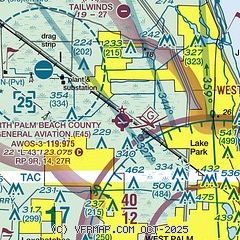
|
| Airport distance calculator |
|---|
|
|
| Sunrise and sunset |
|---|
|
Times for 09-Jun-2026
| | Local
(UTC-4) | | Zulu
(UTC) |
|---|
| Morning civil twilight | | 06:01 | | 10:01 |
| Sunrise | | 06:27 | | 10:27 |
| Sunset | | 20:13 | | 00:13 |
| Evening civil twilight | | 20:39 | | 00:39 |
|
| Current date and time |
|---|
| Zulu (UTC) | 09-Jun-2026 13:52:51 |
|---|
| Local (UTC-4) | 09-Jun-2026 09:52:51 |
|---|
|
| METAR |
|---|
| KF45 | 091335Z AUTO 36002KT 10SM CLR 27/24 A3012 RMK AO2
|
KPBI
12nm SE | 091253Z 35003KT 10SM SCT032 BKN160 BKN250 28/24 A3013 RMK AO2 SLP201 T02830239 $
|
KLNA
17nm SE | 091335Z AUTO 36003KT 10SM SCT020 29/22 A3012 RMK AO2 T02870217
|
|
| TAF |
|---|
KPBI
12nm SE | 091125Z 0912/1012 VRB04KT P6SM FEW040 FM091600 09010KT P6SM SCT030 BKN250 FM100200 VRB05KT P6SM FEW040
|
|
| NOTAMs |
|---|
NOTAMs are issued by the DoD/FAA and will open in a separate window not controlled by AirNav.
|
|


