FAA INFORMATION EFFECTIVE 18 APRIL 2024
Location
| FAA Identifier: | ICT |
| Lat/Long: | 37-38-59.8290N 097-25-58.9540W
37-38.997150N 097-25.982567W
37.6499525,-97.4330428
(estimated) |
| Elevation: | 1332.6 ft. / 406.2 m (surveyed) |
| Variation: | 04E (2015) |
| From city: | 5 miles SW of WICHITA, KS |
| Time zone: | UTC -5 (UTC -6 during Standard Time) |
| Zip code: | 67209 |
Airport Operations
| Airport use: | Open to the public |
| Activation date: | 04/1953 |
| Control tower: | yes |
| ARTCC: | KANSAS CITY CENTER |
| FSS: | WICHITA FLIGHT SERVICE STATION |
| NOTAMs facility: | ICT (NOTAM-D service available) |
| Attendance: | CONTINUOUS |
| Wind indicator: | lighted |
| Segmented circle: | no |
| Beacon: | white-green (lighted land airport)
Operates sunset to sunrise. |
| Fire and rescue: | ARFF index C |
| International operations: | customs landing rights airport |
Airport Communications
| UNICOM: | 122.95 |
| ATIS: | 125.15 |
| WX ASOS: | PHONE 316-945-8022 |
| WICHITA GROUND: | 121.9 348.6 |
| WICHITA TOWER: | 118.2 257.8 |
| WICHITA APPROACH: | 125.5 ;270-009 BLW 5000 FT & BYD 20 126.7 ;191-009 134.85 ;010-190 269.1 ;E IAB BLW 5000 FT 290.275 ;010-190 325.8 ;270-009 BLW 5000 FT & BYD 20 353.5 ;191-009 327.1 |
| WICHITA DEPARTURE: | 126.7 ;191-009 134.85 ;010-190 290.275 ;010-190 353.5 ;191-009 327.1 |
| CLEARANCE DELIVERY: | 125.7 |
| CLASS C: | 126.7 ;191-009 134.8 ;010-190 4000 FT & BLW 134.85 ;010-190 ABV 4000 FT 290.275 ;010-190 ABV 4000 FT 353.5 ;191-009 |
| EMERG: | 121.5 243.0 |
| IC: | 126.7 ;191-009 353.5 ;191-009 |
| RDR: | 317.425 |
| WX AWOS-3PT at BEC (11 nm E): | 119.45 (316-515-7116) |
| WX ASOS at AAO (12 nm NE): | 134.025 (316-636-2541) |
| WX AWOS-2 at 1K1 (17 nm NE): | 118.3 (316-530-6004) |
| WX AWOS-3P at 3AU (17 nm E): | 124.175 (316-733-6696) |
| WX AWOS-3P at EGT (20 nm S): | 118.875 (620-359-2156) |
Nearby radio navigation aids
| VOR radial/distance | | VOR name | | Freq | | Var |
|---|
| ICTr122/9.2 | | WICHITA VORTAC | | 113.80 | | 07E |
| HUTr127/31.6 | | HUTCHINSON VOR/DME | | 116.80 | | 04E |
| NDB name | | Hdg/Dist | | Freq | | Var | | ID |
|---|
| PICHE | | 010/4.4 | | 332 | | 04E | | IC | .. -.-. |
Airport Services
| Fuel available: | 100LL JET-A |
| Parking: | hangars and tiedowns |
| Airframe service: | MAJOR |
| Powerplant service: | MAJOR |
| Bottled oxygen: | HIGH/LOW |
| Bulk oxygen: | HIGH/LOW |
Runway Information
Runway 1L/19R
| Dimensions: | 10302 x 150 ft. / 3140 x 46 m |
| Surface: | concrete/grooved, in good condition |
| Weight bearing capacity: | | PCN 72 /R/B/W/T | | Single wheel: | 100.0 | | Double wheel: | 210.0 | | Double tandem: | 300.0 |
|
| Runway edge lights: | high intensity |
| RUNWAY 1L | | RUNWAY 19R |
| Latitude: | 37-38.101075N | | 37-39.696105N |
| Longitude: | 097-26.759843W | | 097-26.029860W |
| Elevation: | 1312.5 ft. | | 1329.6 ft. |
| Traffic pattern: | left | | right |
| Runway heading: | 016 magnetic, 020 true | | 196 magnetic, 200 true |
| Declared distances: | TORA:10301 TODA:10301 ASDA:10301 LDA:10301 | | TORA:10301 TODA:10301 ASDA:10301 LDA:10301 |
| Markings: | precision, in good condition | | precision, in good condition |
| RVR equipment: | touchdown, midfield, rollout | | touchdown, midfield, rollout |
| Approach lights: | ALSF2: standard 2,400 foot high intensity approach lighting system with centerline sequenced flashers (category II or III) | | MALSR: 1,400 foot medium intensity approach lighting system with runway alignment indicator lights |
| Centerline lights: | yes | | yes |
| Touchdown point: | yes, lighted | | yes, no lights |
| Instrument approach: | ILS | | ILS |
Runway 1R/19L
| Dimensions: | 7302 x 150 ft. / 2226 x 46 m |
| Surface: | concrete/grooved, in good condition |
| Weight bearing capacity: | | PCN 66 /R/B/W/T | | Single wheel: | 125.0 | | Double wheel: | 240.0 | | Double tandem: | 400.0 |
|
| Runway edge lights: | high intensity |
| RUNWAY 1R | | RUNWAY 19L |
| Latitude: | 37-38.565735N | | 37-39.696182N |
| Longitude: | 097-25.577160W | | 097-25.059413W |
| Elevation: | 1321.0 ft. | | 1319.8 ft. |
| Traffic pattern: | right | | left |
| Runway heading: | 016 magnetic, 020 true | | 196 magnetic, 200 true |
| Declared distances: | TORA:7302 TODA:7302 ASDA:7302 LDA:7302 | | TORA:7302 TODA:7302 ASDA:7302 LDA:7302 |
| Markings: | precision, in good condition | | precision, in good condition |
| Visual slope indicator: | | | 4-light PAPI on left (3.00 degrees glide path) |
| RVR equipment: | touchdown, rollout | | touchdown, rollout |
| Approach lights: | MALSR: 1,400 foot medium intensity approach lighting system with runway alignment indicator lights | | MALSR: 1,400 foot medium intensity approach lighting system with runway alignment indicator lights |
| Runway end identifier lights: | | | no |
| Touchdown point: | yes, no lights | | yes, no lights |
| Instrument approach: | ILS/DME | | ILS/DME |
Runway 14/32
| Dimensions: | 6301 x 150 ft. / 1921 x 46 m |
| Surface: | concrete/grooved, in good condition |
| Weight bearing capacity: | | PCN 72 /R/B/W/T | | Single wheel: | 100.0 | | Double wheel: | 190.0 | | Double tandem: | 280.0 |
|
| Runway edge lights: | high intensity |
| RUNWAY 14 | | RUNWAY 32 |
| Latitude: | 37-39.452700N | | 37-38.553560N |
| Longitude: | 097-26.404550W | | 097-25.751668W |
| Elevation: | 1332.1 ft. | | 1321.6 ft. |
| Traffic pattern: | left | | left |
| Runway heading: | 146 magnetic, 150 true | | 326 magnetic, 330 true |
| Declared distances: | TORA:6301 TODA:6301 ASDA:6301 LDA:6301 | | TORA:6301 TODA:6301 ASDA:6301 LDA:6301 |
| Markings: | nonprecision, in good condition | | basic, in good condition |
| Visual slope indicator: | 4-light PAPI on left (3.00 degrees glide path) | | 4-light PAPI on left (3.00 degrees glide path) |
| Runway end identifier lights: | yes | | yes |
| Touchdown point: | yes, no lights | | yes, no lights |
Airport Ownership and Management from official FAA records
| Ownership: | Publicly-owned |
| Owner: | WICHITA AIRPORT AUTHORITY
2173 AIR CARGO ROAD
WICHITA, KS 67209
Phone 316-946-4700 |
| Manager: | MR. JESSE ROMO, A.A.E.
2173 AIR CARGO ROAD
WICHITA, KS 67209
Phone 316-946-4700 |
Airport Operational Statistics
| Aircraft based on the field: | | 122 | | Single engine airplanes: | | 66 | | Multi engine airplanes: | | 14 | | Jet airplanes: | | 38 | | Helicopters: | | 4 |
| |  | |
| Aircraft operations: avg 306/day * | | 35% | transient general aviation | | 17% | local general aviation | | 17% | air taxi | | 15% | commercial | | 15% | military | | * for 12-month period ending 30 April 2023 | |
Additional Remarks
| - | TWY H CLSD TO ACFT WITH WINGSPAN MORE THAN 79. |
| - | TWY L AND L1 CLSD TO ACFT WITH WINGSPAN MORE THAN 118. |
| - | TWY P CLSD TO ACFT WITH WINGSPAN MORE THAN 79. |
| - | AIR CARGO RAMP CLSD TO ACFT WINGSPAN MORE THAN 148 FT. |
| - | ACFT PARKING BAS CONTACT 132.00 FOR PARKING INSTRUCTIONS PRIOR TO EXITING TWY L1. |
| - | FLIGHT NOTIFICATION SERVICE (ADCUS) AVBL. |
| - | AIRCRAFT ENGINE RUNS ABOVE IDLE NOT APPROVED ON AIRCRAFT PARKING RAMPS. |
| - | PPR REQUIRED FOR ACFT CARRYING CLASS 1DIVISION 1.1, 1.2 OR 1.3 EXPLOSIVES AS DEFINED BY 49 CFR 173.50 OR AS AMENDED. |
| - | MIGRATORY BIRDS ON AND IN VICINITY OF ARPT, ALL QUADS. |
| - | ATTENDED CONTINUOUSLY. |
| - | ATCT HAS LTD VIS OF TRML GATES 1 THRU 8, TWY H, AND CUSTOMS PRKG RAMP. |
| - | CALL FOR GATE PUSHBACK NOT REQUIRED. |
| - | TWYS F, G, H, J, P AND ALL ACFT PARKING RAMPS ARE NONMOVEMENT AREAS. |
Instrument Procedures
NOTE: All procedures below are presented as PDF files. If you need a reader for these files, you should download the free Adobe Reader.NOT FOR NAVIGATION. Please procure official charts for flight.
FAA instrument procedures published for use from 18 April 2024 at 0901Z to 16 May 2024 at 0900Z.
IAPs - Instrument Approach Procedures |
|---|
| ILS OR LOC RWY 01L | |
download (242KB) |
| ILS OR LOC RWY 01R | |
download (264KB) |
| ILS OR LOC RWY 19L | |
download (309KB) |
| ILS OR LOC RWY 19R | |
download (297KB) |
| ILS RWY 01L (SA CAT I) | |
download (214KB) |
| ILS RWY 01L (CAT II) | |
download (203KB) |
| RNAV (RNP) Z RWY 01L | |
download (242KB) |
| RNAV (RNP) Z RWY 14 | |
download (246KB) |
| RNAV (RNP) Z RWY 19L | |
download (271KB) |
| RNAV (RNP) Z RWY 19R | |
download (244KB) |
| RNAV (GPS) RWY 01R | |
download (289KB) |
| RNAV (GPS) RWY 32 | |
download (252KB) |
| RNAV (GPS) Y RWY 01L | |
download (286KB) |
| RNAV (GPS) Y RWY 14 | |
download (262KB) |
| RNAV (GPS) Y RWY 19L | |
download (283KB) |
| RNAV (GPS) Y RWY 19R | |
download (272KB) |
| VOR RWY 14 | |
download (226KB) |
| NDB RWY 01R | |
download (209KB) |
| NOTE: Special Alternate Minimums apply | |
download (149KB) |
| NOTE: Special Take-Off Minimums/Departure Procedures apply | |
download (360KB) |
Other nearby airports with instrument procedures:
KIAB - Mc Connell Air Force Base (8 nm E)
KCEA - Cessna Aircraft Field Airport (9 nm E)
KBEC - Beech Factory Airport (11 nm E)
KAAO - Colonel James Jabara Airport (12 nm NE)
1K1 - Lloyd Stearman Field Airport (17 nm NE)
3AU - Augusta Municipal Airport (17 nm E)
KEGT - Wellington Municipal Airport (20 nm S)
|
|

Road maps at:
MapQuest
Bing
Google
| Aerial photo |
|---|
WARNING: Photo may not be current or correct
 Photo by David Newcomer
Photo taken 09-Oct-2015
looking north from 4,000 altitude.
Photo by David Newcomer
Photo taken 09-Oct-2015
looking north from 4,000 altitude.
Do you have a better or more recent aerial photo of Wichita Dwight D Eisenhower National Airport that you would like to share? If so, please send us your photo.
|
| Sectional chart |
|---|
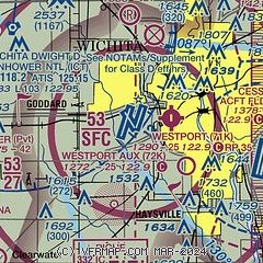
|
CAUTION: Diagram may not be current
 Download PDF
of official airport diagram from the FAA
| Airport distance calculator |
|---|
|
|
| Sunrise and sunset |
|---|
|
Times for 25-Apr-2024
| | Local
(UTC-5) | | Zulu
(UTC) |
|---|
| Morning civil twilight | | 06:13 | | 11:13 |
| Sunrise | | 06:41 | | 11:41 |
| Sunset | | 20:14 | | 01:14 |
| Evening civil twilight | | 20:42 | | 01:42 |
|
| Current date and time |
|---|
| Zulu (UTC) | 25-Apr-2024 11:02:25 |
|---|
| Local (UTC-5) | 25-Apr-2024 06:02:25 |
|---|
|
| METAR |
|---|
| KICT | 251053Z 12009KT 10SM OVC016 17/09 A2995 RMK AO2 SLP133 T01670089
|
KIAB
8nm E | 251055Z AUTO 13005KT 10SM OVC015 17/09 A2995 RMK AO2 CIG 014 RWY01 SLP136 T01690091
|
KBEC
11nm E | 251035Z AUTO 10004KT 10SM OVC017 16/08 A2996 RMK AO2 LTG DSNT E T01580080
|
KAAO
12nm NE | 251054Z AUTO 10005KT 10SM OVC017 16/09 A2997 RMK AO2 SLP140 T01610089
|
K3AU
17nm E | 251055Z AUTO RMK AO2 PWINO PNO
|
KEGT
20nm S | 251035Z AUTO 13008KT 10SM BKN014 OVC027 16/10 A2995 RMK AO2 T01640103
|
|
| TAF |
|---|
| KICT | 251022Z 2510/2606 13011KT P6SM OVC016 FM251400 15014KT P6SM VCTS OVC009CB FM251800 13015G23KT P6SM OVC011
|
KIAB
8nm E | 250200Z 2502/2608 13012KT 9999 OVC085 QNH2999INS BECMG 2508/2509 13012G18KT 9000 -SHRA OVC030 QNH2996INS BECMG 2511/2512 12012G18KT 8000 -SHRA VCTS BKN010 OVC020CB QNH2978INS TEMPO 2514/2520 18015G25KT 8000 -TSRA BKN005 OVC010CB BECMG 2521/2522 13012G18KT 9000 -SHRA BKN005 OVC010 QNH2969INS BECMG 2601/2602 15015G20KT 9000 -SHRA OVC005 WS020/17045KT QNH2958INS TX20/2521Z TN13/2512Z
|
|
| NOTAMs |
|---|
NOTAMs are issued by the DoD/FAA and will open in a separate window not controlled by AirNav.
|
|


