FAA INFORMATION EFFECTIVE 18 APRIL 2024
Location
| FAA Identifier: | CTJ |
| Lat/Long: | 33-37-54.1072N 085-09-08.1509W
33-37.901787N 085-09.135848W
33.6316964,-85.1522641
(estimated) |
| Elevation: | 1164.5 ft. / 354.9 m (surveyed) |
| Variation: | 04W (2005) |
| From city: | 5 miles NW of CARROLLTON, GA |
| Time zone: | UTC -4 (UTC -5 during Standard Time) |
| Zip code: | 30117 |
Airport Operations
| Airport use: | Open to the public |
| Activation date: | 10/1970 |
| Control tower: | no |
| ARTCC: | ATLANTA CENTER |
| FSS: | MACON FLIGHT SERVICE STATION |
| NOTAMs facility: | MCN (NOTAM-D service available) |
| Attendance: | MON-SAT 0800-1800, ALL SUN 1300-1700 |
| Wind indicator: | lighted |
| Segmented circle: | yes |
| Lights: | HIRL RWY 17/35 PRESET MED INTST DUSK-2200, AFT 2200 ACTVT - CTAF. |
| Beacon: | white-green (lighted land airport)
Operates sunset to sunrise. |
Airport Communications
| CTAF/UNICOM: | 122.975 |
| WX AWOS-3: | 118.175 (770-214-9667) |
| ATLANTA APPROACH: | 121.0 [0645-2300] |
| ATLANTA DEPARTURE: | 121.0 [0645-2300] |
| CLEARANCE DELIVERY: | 121.6 |
| WX AWOS-3 at PUJ (20 nm NE): | 126.225 (770-445-3870) |
Nearby radio navigation aids
| VOR radial/distance | | VOR name | | Freq | | Var |
|---|
| RMGr182/31.9 | | ROME VORTAC | | 115.40 | | 01E |
| LGCr003/35.1 | | LAGRANGE VORTAC | | 115.60 | | 01E |
| NDB name | | Hdg/Dist | | Freq | | Var | | ID |
|---|
| CARROLLTON | | 349/4.1 | | 278 | | 04W | | GPQ | --. .--. --.- |
| COWETA COUNTY | | 319/31.4 | | 234 | | 03W | | EQQ | . --.- --.- |
| PECAT | | 306/38.8 | | 316 | | 05W | | FFC | ..-. ..-. -.-. |
Airport Services
| Fuel available: | 100LL JET-A+ |
| Parking: | hangars and tiedowns |
| Airframe service: | MAJOR |
| Powerplant service: | MAJOR |
| Bottled oxygen: | NONE |
| Bulk oxygen: | NONE |
Runway Information
Runway 17/35
| Dimensions: | 5503 x 100 ft. / 1677 x 30 m |
| Surface: | asphalt, in good condition |
| Weight bearing capacity: | | Single wheel: | 43.0 | | Double wheel: | 56.0 | | Double tandem: | 83.0 |
|
| Runway edge lights: | high intensity |
| RUNWAY 17 | | RUNWAY 35 |
| Latitude: | 33-38.337483N | | 33-37.466088N |
| Longitude: | 085-09.286862W | | 085-08.984835W |
| Elevation: | 1164.4 ft. | | 1110.2 ft. |
| Traffic pattern: | left | | left |
| Runway heading: | 168 magnetic, 164 true | | 348 magnetic, 344 true |
| Markings: | nonprecision, in good condition | | precision, in good condition |
| Visual slope indicator: | 4-light PAPI on left (3.00 degrees glide path) | | 4-light PAPI on left (3.00 degrees glide path) |
| Touchdown point: | yes, no lights | | yes, no lights |
| Instrument approach: | | | LOC/GS |
| Obstructions: | 26 ft. trees, 642 ft. from runway, 497 ft. left of centerline, 17:1 slope to clear | | 30 ft. trees, 1040 ft. from runway, 600 ft. right of centerline, 28:1 slope to clear |
Airport Ownership and Management from official FAA records
| Ownership: | Publicly-owned |
| Owner: | WEST GA ARPT AUTH
635 REGIONAL AIRPORT ROAD
CARROLLTON, GA 30117
Phone 770-354-5927 |
| Manager: | SUSAN HEATH
635 REGIONAL AIRPORT ROAD
CARROLLTON, GA 30117
Phone 770-354-5927 |
Airport Operational Statistics
| Aircraft based on the field: | | 145 | | Single engine airplanes: | | 106 | | Multi engine airplanes: | | 32 | | Jet airplanes: | | 4 | | Helicopters: | | 2 | | Gliders airplanes: | | 1 |
| |  | |
| Aircraft operations: avg 82/day * | | 49% | transient general aviation | | 49% | local general aviation | | 2% | military | | * for 12-month period ending 31 December 2021 | |
Additional Remarks
| - | DEER AND TURKEYS ON & NEAR RWYS AT ALL TIMES. |
| - | FOR APCH/DEP SVC CTC ATLANTA APCH AT 678-364-6131. IF RLS TIME IS EXPD TO BE LESS THAN 5 MINS, CTC CD. |
Instrument Procedures
NOTE: All procedures below are presented as PDF files. If you need a reader for these files, you should download the free Adobe Reader.NOT FOR NAVIGATION. Please procure official charts for flight.
FAA instrument procedures published for use from 18 April 2024 at 0901Z to 16 May 2024 at 0900Z.
STARs - Standard Terminal Arrivals |
|---|
| DEHAN THREE (RNAV) | |
2 pages:
[1] [2] (326KB) |
IAPs - Instrument Approach Procedures |
|---|
| ILS OR LOC RWY 35 | |
download (243KB) |
| RNAV (GPS) RWY 17 | |
download (244KB) |
| RNAV (GPS) RWY 35 | |
download (250KB) |
| NOTE: Special Alternate Minimums apply | |
download (154KB) |
| NOTE: Special Take-Off Minimums/Departure Procedures apply | |
download (479KB) |
Other nearby airports with instrument procedures:
KPUJ - Paulding Northwest Atlanta Airport (20 nm NE)
4A4 - Polk County Airport/Cornelius Moore Field (23 nm N)
KCCO - Newnan Coweta County Airport (27 nm SE)
KFTY - Fulton County Executive Airport/Charlie Brown Field (33 nm E)
KVPC - Cartersville Airport (33 nm NE)
|
|

Road maps at:
MapQuest
Bing
Google
| Aerial photo |
|---|
WARNING: Photo may not be current or correct
 Photo courtesy of AirNav, LLC
Photo taken 22-Dec-2012
looking south.
Photo courtesy of AirNav, LLC
Photo taken 22-Dec-2012
looking south.
Do you have a better or more recent aerial photo of West Georgia Regional Airport-O V Gray Field that you would like to share? If so, please send us your photo.
|
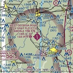
| Sectional chart |
|---|
|
| Airport distance calculator |
|---|
|
|
| Sunrise and sunset |
|---|
|
Times for 18-Apr-2024
| | Local
(UTC-4) | | Zulu
(UTC) |
|---|
| Morning civil twilight | | 06:40 | | 10:40 |
| Sunrise | | 07:06 | | 11:06 |
| Sunset | | 20:13 | | 00:13 |
| Evening civil twilight | | 20:39 | | 00:39 |
|
| Current date and time |
|---|
| Zulu (UTC) | 18-Apr-2024 19:48:26 |
|---|
| Local (UTC-4) | 18-Apr-2024 15:48:26 |
|---|
|
| METAR |
|---|
| KCTJ | 181935Z AUTO 20005KT 10SM BKN039 26/17 A3010 RMK AO2 T02640167 PNO
|
KPUJ
20nm NE | 181935Z AUTO 15004KT 10SM CLR 28/13 A3005 RMK AO2
|
|
| TAF |
|---|
KFTY
33nm E | 181720Z 1818/1918 23004KT P6SM SCT035 SCT200 FM190100 VRB03KT P6SM SCT035 BKN090 PROB30 1903/1905 4SM -SHRA BR OVC025 FM191100 VRB03KT P6SM -SHRA FEW025 BKN090 FM191500 26007KT P6SM SCT035 BKN100
|
KANB
35nm W | 181720Z 1818/1918 VRB04KT P6SM BKN035 FM190100 23006KT P6SM VCSH BKN100 FM190400 VRB04KT P6SM BKN090 PROB30 1904/1907 4SM TSRA BR OVC025CB FM191000 23005KT 5SM BR OVC025 FM191400 24006KT P6SM OVC015
|
KATL
35nm E | 181720Z 1818/1924 24004KT P6SM SCT035 SCT200 FM190100 23003KT P6SM SCT035 BKN090 PROB30 1903/1905 4SM -SHRA BR OVC025 FM191100 VRB03KT P6SM -SHRA FEW025 BKN090 FM191500 27007KT P6SM SCT035 BKN100 FM191900 27008KT P6SM VCSH BKN040
|
KRYY
36nm NE | 181720Z 1818/1918 23005KT P6SM SCT035 SCT200 FM190000 VRB03KT P6SM SCT025 BKN090 PROB30 1902/1905 4SM -SHRA BR OVC025 FM191100 VRB03KT P6SM -SHRA SCT025 BKN080 FM191600 27006KT P6SM SCT035 BKN100
|
KMGE
36nm NE | 172115Z 1721/1903 24009KT 9999 SCT050 BKN140 BKN200 BKN250 QNH3006INS BECMG 1722/1723 27010G15KT 9000 -SHRA BR BKN025 OVC070 QNH3005INS BECMG 1800/1801 29007KT 9999 NSW SCT050 BKN120 BKN200 BKN250 QNH3007INS BECMG 1808/1809 VRB05KT 4800 BR OVC010 QNH3009INS BECMG 1813/1814 29007KT 9999 NSW FEW020 SCT040 SCT090 QNH3012INS BECMG 1900/1901 VRB05KT 9999 FEW050 FEW150 QNH3015INS TX29/1819Z TN16/1812Z LAST NO AMDS AFT 1803 NEXT 1811
|
|
| NOTAMs |
|---|
NOTAMs are issued by the DoD/FAA and will open in a separate window not controlled by AirNav.
|
|


