FAA INFORMATION EFFECTIVE 18 APRIL 2024
Location
| FAA Identifier: | EFT |
| Lat/Long: | 42-36-53.6425N 089-35-25.4522W
42-36.894042N 089-35.424203W
42.6149007,-89.5904034
(estimated) |
| Elevation: | 1085.5 ft. / 330.9 m (surveyed) |
| Variation: | 00E (1985) |
| From city: | 3 miles NE of MONROE, WI |
| Time zone: | UTC -5 (UTC -6 during Standard Time) |
| Zip code: | 53566 |
Airport Operations
| Airport use: | Open to the public |
| Activation date: | 11/1963 |
| Control tower: | no |
| ARTCC: | CHICAGO CENTER |
| FSS: | GREEN BAY FLIGHT SERVICE STATION |
| NOTAMs facility: | EFT (NOTAM-D service available) |
| Attendance: | APR-OCT 0700-1700, NOV-MAR 0800-1600
FOR ATTENDANT AFT HRS CALL 608-329-7777. |
| Wind indicator: | lighted |
| Segmented circle: | no |
| Lights: | MIRL RY 12/30 OPERS LOW INTST; TO INCR INTST & ACTVT REIL RY 02/20; PAPI RY 02; MIRL RY 02/20; REIL RY 12/30; PAPI RY 12/30; MIRL RY 12/30 - CTAF. |
| Beacon: | white-green (lighted land airport)
Operates sunset to sunrise. |
Airport Communications
| CTAF/UNICOM: | 123.05 |
| WX AWOS-3: | 118.375 (608-328-8359) |
| ROCKFORD APPROACH: | 126.0 |
| ROCKFORD DEPARTURE: | 126.0 |
Nearby radio navigation aids
| VOR radial/distance | | VOR name | | Freq | | Var |
|---|
| JVLr276/21.7 | | JANESVILLE VOR/DME | | 114.30 | | 03E |
| MSNr196/33.7 | | MADISON VORTAC | | 108.60 | | 03E |
Airport Services
| Fuel available: | 100LL JET-A
100LL:24 HR FUEL AVBL WITH CREDIT CARD. |
| Parking: | hangars and tiedowns |
| Airframe service: | MAJOR |
| Powerplant service: | MAJOR |
| Bottled oxygen: | HIGH/LOW |
| Bulk oxygen: | NONE |
Runway Information
Runway 12/30
| Dimensions: | 5000 x 75 ft. / 1524 x 23 m |
| Surface: | asphalt, in excellent condition |
| Weight bearing capacity: | |
| Runway edge lights: | medium intensity |
| RUNWAY 12 | | RUNWAY 30 |
| Latitude: | 42-37.127318N | | 42-36.695115N |
| Longitude: | 089-35.809548W | | 089-34.861075W |
| Elevation: | 1085.5 ft. | | 1061.5 ft. |
| Traffic pattern: | left | | left |
| Runway heading: | 122 | | 302 |
| Markings: | nonprecision, in good condition | | nonprecision, in good condition |
| Visual slope indicator: | 2-light PAPI on left (3.15 degrees glide path) | | 2-light PAPI on left (3.00 degrees glide path)
PAPI UNUSBL BYD 6 DEGS RIGHT OF CNTRLN. |
| Runway end identifier lights: | yes | | yes |
| Touchdown point: | yes, no lights | | yes, no lights |
Runway 2/20
| Dimensions: | 3000 x 75 ft. / 914 x 23 m |
| Surface: | asphalt, in fair condition |
| Runway edge lights: | medium intensity |
| RUNWAY 2 | | RUNWAY 20 |
| Latitude: | 42-36.626673N | | 42-37.100468N |
| Longitude: | 089-35.668915W | | 089-35.480813W |
| Elevation: | 1056.0 ft. | | 1084.8 ft. |
| Traffic pattern: | left | | left |
| Runway heading: | 016 | | 196 |
| Markings: | basic, in fair condition | | basic, in fair condition |
| Visual slope indicator: | 2-light PAPI on left (3.00 degrees glide path) | | |
| Runway end identifier lights: | yes | | yes |
| Touchdown point: | yes, no lights | | yes, no lights |
| Obstructions: | 15 ft. tree, 340 ft. from runway, 90 ft. left of centerline, 20:1 slope to clear | | 43 ft. trees, 890 ft. from runway, 150 ft. left of centerline, 20:1 slope to clear |
Airport Ownership and Management from official FAA records
| Ownership: | Publicly-owned |
| Owner: | CITY OF MONROE
1110 18TH AVENUE
MONROE, WI 53566
Phone 608-329-4101 |
| Manager: | ROB DRIVER
W4711 HWY 59
MONROE, WI 53566
Phone (608) 329-7777 |
Airport Operational Statistics
| Aircraft based on the field: | | 41 | | Single engine airplanes: | | 40 | | Jet airplanes: | | 1 |
| |  | |
| Aircraft operations: avg 47/day * | | 49% | local general aviation | | 47% | transient general aviation | | 3% | air taxi | | 2% | military | | * for 12-month period ending 16 April 2021 | |
Additional Remarks
| - | FOR CD CTC CHICAGO ARTCC AT 630-906-8921. |
Instrument Procedures
NOTE: All procedures below are presented as PDF files. If you need a reader for these files, you should download the free Adobe Reader.NOT FOR NAVIGATION. Please procure official charts for flight.
FAA instrument procedures published for use from 18 April 2024 at 0901Z to 16 May 2024 at 0900Z.
IAPs - Instrument Approach Procedures |
|---|
| RNAV (GPS) RWY 12 | |
download (220KB) |
| RNAV (GPS) RWY 30 | |
download (210KB) |
| VOR/DME RWY 30 | |
download (234KB) |
| NOTE: Special Alternate Minimums apply | |
download (32KB) |
| NOTE: Special Take-Off Minimums/Departure Procedures apply | |
download (201KB) |
Other nearby airports with instrument procedures:
KFEP - Albertus Airport (22 nm S)
KJVL - Southern Wisconsin Regional Airport (24 nm E)
44C - Beloit Airport (28 nm E)
C29 - Middleton Municipal Airport - Morey Field (30 nm N)
KMRJ - Iowa County Airport (33 nm NW)
|
|

Road maps at:
MapQuest
Bing
Google
| Aerial photo |
|---|
WARNING: Photo may not be current or correct
 Photo by Mathieu Labs
Photo taken 13-Jun-2018
looking north-northwest.
Photo by Mathieu Labs
Photo taken 13-Jun-2018
looking north-northwest.
Do you have a better or more recent aerial photo of Monroe Municipal Airport that you would like to share? If so, please send us your photo.
|
| Sectional chart |
|---|
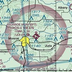
|
| Airport distance calculator |
|---|
|
|
| Sunrise and sunset |
|---|
|
Times for 19-Apr-2024
| | Local
(UTC-5) | | Zulu
(UTC) |
|---|
| Morning civil twilight | | 05:40 | | 10:40 |
| Sunrise | | 06:10 | | 11:10 |
| Sunset | | 19:45 | | 00:45 |
| Evening civil twilight | | 20:14 | | 01:14 |
|
| Current date and time |
|---|
| Zulu (UTC) | 20-Apr-2024 04:19:49 |
|---|
| Local (UTC-5) | 19-Apr-2024 23:19:49 |
|---|
|
| METAR |
|---|
| KEFT | 200355Z AUTO 29015G22KT 10SM CLR 03/M02 A3013 RMK AO2 T00331025
|
|
| TAF |
|---|
KJVL
25nm E | 192048Z 1921/2018 27019G30KT P6SM SCT060 FM200300 29010KT P6SM FEW250 FM201500 30013KT P6SM SCT070
|
|
| NOTAMs |
|---|
NOTAMs are issued by the DoD/FAA and will open in a separate window not controlled by AirNav.
|
|

