FAA INFORMATION EFFECTIVE 27 NOVEMBER 2025
Location
| FAA Identifier: | SKX |
| Lat/Long: | 36-27-06.1000N 105-40-23.1000W
36-27.101667N 105-40.385000W
36.4516944,-105.6730833
(estimated) |
| Elevation: | 7094.6 ft. / 2162.4 m (surveyed) |
| Variation: | 09E (2010) |
| From city: | 8 miles NW of TAOS, NM |
| Time zone: | UTC -7 (UTC -6 during Daylight Saving Time) |
| Zip code: | 87571 |
Airport Operations
| Airport use: | Open to the public |
| Activation date: | 03/1967 |
| Control tower: | no |
| ARTCC: | ALBUQUERQUE CENTER |
| FSS: | ALBUQUERQUE FLIGHT SERVICE STATION |
| NOTAMs facility: | SKX (NOTAM-D service available) |
| Attendance: | 0730-1800 |
| Wind indicator: | lighted |
| Segmented circle: | yes |
| Lights: | ACTVT REIL RWY 04, 13, 31; PAPI RWY 04, 13, 22, 31; MIRL RWY 04/22, 13/31 - CTAF. |
| Beacon: | white-green (lighted land airport)
Operates sunset to sunrise. |
Airport Communications
| CTAF/UNICOM: | 122.8 |
| WX AWOS-3PT: | 132.975 (575-758-5663) |
| WX AWOS-3 at AXX (19 nm E): | 118.025 (575-377-0526) |
- COMMUNICATIONS PRVDD BY ALBUQUERQUE RADIO ON FREQS 122.1R/117.6T (TAOS RCO).
- APCH/DEP SVC PRVDD BY ALBUQUERQUE ARTCC (ZAB) 132.8/346.35 (CLINES CORNER RCAG).
Nearby radio navigation aids
| VOR radial/distance | | VOR name | | Freq | | Var |
|---|
| TASr117/14.7 | | TAOS VORTAC | | 115.80 | | 13E |
| CIMr253/38.7 | | CIMARRON VORTAC | | 116.40 | | 13E |
Airport Services
| Fuel available: | 100LL JET-A1+
100LL:FOR AFT HRS FUEL SVC CALL 575-758-5436. AFT HRS CALLOUT FEE CHARGED FOR JET A. |
| Parking: | hangars and tiedowns |
| Airframe service: | MINOR |
| Powerplant service: | MINOR |
Runway Information
Runway 13/31
| Dimensions: | 8600 x 100 ft. / 2621 x 30 m |
| Surface: | concrete/grooved, in good condition |
| Weight bearing capacity: | | PCN 51 /F/D/X/T | | Single wheel: | 60.0 |
|
| Runway edge lights: | medium intensity |
| Operational restrictions: | RWY 13: 150 FT BLAST PAD. RWY 31: 150 FT BLAST PAD. |
| RUNWAY 13 | | RUNWAY 31 |
| Latitude: | 36-27.364883N | | 36-26.322005N |
| Longitude: | 105-41.021017W | | 105-39.833837W |
| Elevation: | 7047.3 ft. | | 7024.9 ft. |
| Traffic pattern: | left | | left |
| Runway heading: | 128 magnetic, 137 true | | 308 magnetic, 317 true |
| Markings: | precision, in good condition | | nonprecision, in good condition |
| Visual slope indicator: | 4-light PAPI on left (3.00 degrees glide path) | | 4-light PAPI on left (3.00 degrees glide path) |
| Runway end identifier lights: | yes | | yes |
| Touchdown point: | yes, no lights | | yes, no lights |
Runway 4/22
| Dimensions: | 5504 x 75 ft. / 1678 x 23 m |
| Surface: | asphalt/porous friction courses, in good condition |
| Weight bearing capacity: | | PCN 4 /F/D/Y/T | | Single wheel: | 24.0 |
|
| Runway edge lights: | medium intensity |
| Operational restrictions: | RWY 04: 150 FT BLAST PAD. RWY 22: 250 FT BLAST PAD. |
| RUNWAY 4 | | RUNWAY 22 |
| Latitude: | 36-27.251757N | | 36-27.757185N |
| Longitude: | 105-40.786142W | | 105-39.854127W |
| Elevation: | 7052.4 ft. | | 7094.6 ft. |
| Traffic pattern: | left | | left |
| Runway heading: | 047 magnetic, 056 true | | 227 magnetic, 236 true |
| Markings: | nonprecision, in good condition | | basic, in good condition |
| Visual slope indicator: | 4-light PAPI on left (3.00 degrees glide path) | | 4-light PAPI on left (3.00 degrees glide path) |
| Runway end identifier lights: | yes | | no |
| Touchdown point: | yes, no lights | | yes, no lights |
Airport Ownership and Management from official FAA records
| Ownership: | Publicly-owned |
| Owner: | TOWN OF TAOS
400 CAMINO DE LA PLACITA
TAOS, NM 87571-6071
Phone 575-751-2000 |
| Manager: | COLTON RAPSTINE
24662 HIGHWAY 64
EL PRADO, NM 87529
Phone 575-770-1699
EMER FONE: 575-770-1699 (CELL). |
Additional Remarks
| - | AVOID OVERFLIGHT OF TAOS PUEBLO WORLD HERITAGE SITE 5 NM EAST OF ARPT. |
| - | RWY 04/22 PARALLEL TWY HAS RETRO-REFLECTORS. |
| - | WILDLIFE INVOF ARPT. |
| - | FOR CD IF UNA TO CTC ON FSS FREQ, CTC ALBUQUERQUE ARTCC AT 505-856-4561. |
Instrument Procedures
NOTE: All procedures below are presented as PDF files. If you need a reader for these files, you should download the free Adobe Reader.NOT FOR NAVIGATION. Please procure official charts for flight.
FAA instrument procedures published for use from 27 November 2025 at 0901Z to 25 December 2025 at 0900Z.
IAPs - Instrument Approach Procedures |
|---|
| RNAV (GPS) RWY 04 | |
download (299KB) |
| RNAV (GPS) RWY 13 | |
download (325KB) |
| VOR/DME-B | |
download (325KB) |
| NOTE: Special Alternate Minimums apply | |
download (54KB) |
| NOTE: Special Take-Off Minimums/Departure Procedures apply | |
download (178KB) |
Other nearby airports with instrument procedures:
KAXX - Angel Fire Airport (19 nm E)
KLAM - Los Alamos Airport (45 nm SW)
KSAF - Santa Fe Regional Airport (54 nm S)
KLVS - Las Vegas Municipal Airport (54 nm SE)
KRTN - Raton Municipal Airport/Crews Field (59 nm E)
|
|

Road maps at:
MapQuest
Bing
Google
| Aerial photo |
|---|
WARNING: Photo may not be current or correct
 Photo by Thomas Blog
Photo taken 10-Sep-2017
looking northeast.
Photo by Thomas Blog
Photo taken 10-Sep-2017
looking northeast.
Do you have a better or more recent aerial photo of Taos Regional Airport that you would like to share? If so, please send us your photo.
|
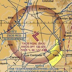
| Sectional chart |
|---|
|
| Airport distance calculator |
|---|
|
|
| Sunrise and sunset |
|---|
|
Times for 28-Nov-2025
| | Local
(UTC-7) | | Zulu
(UTC) |
|---|
| Morning civil twilight | | 06:26 | | 13:26 |
| Sunrise | | 06:54 | | 13:54 |
| Sunset | | 16:47 | | 23:47 |
| Evening civil twilight | | 17:15 | | 00:15 |
|
| Current date and time |
|---|
| Zulu (UTC) | 29-Nov-2025 04:10:47 |
|---|
| Local (UTC-7) | 28-Nov-2025 21:10:47 |
|---|
|
| METAR |
|---|
KAXX
19nm E | 290355Z AUTO 27018G27KT 10SM CLR 04/M05 A2997 RMK AO2 T00411055
|
|
| NOTAMs |
|---|
NOTAMs are issued by the DoD/FAA and will open in a separate window not controlled by AirNav.
|
|


