FAA INFORMATION EFFECTIVE 18 APRIL 2024
Location
| FAA Identifier: | TEB |
| Lat/Long: | 40-51-00.4000N 074-03-39.0000W
40-51.006667N 074-03.650000W
40.8501111,-74.0608333
(estimated) |
| Elevation: | 8.4 ft. / 2.6 m (surveyed) |
| Variation: | 12W (1980) |
| From city: | 1 mile SW of TETERBORO, NJ |
| Time zone: | UTC -4 (UTC -5 during Standard Time) |
| Zip code: | 07608 |
Airport Operations
| Airport use: | Open to the public |
| Activation date: | 01/1947 |
| Control tower: | yes |
| ARTCC: | NEW YORK CENTER |
| FSS: | MILLVILLE FLIGHT SERVICE STATION |
| NOTAMs facility: | TEB (NOTAM-D service available) |
| Attendance: | CONTINUOUS |
| Pattern altitude: | TPA 1500 FT MSL FOR LARGE/TURBINE ACFT; 1000 FT MSL FOR ALL OTHERS. |
| Wind indicator: | lighted |
| Segmented circle: | no |
| Lights: | SS-SR |
| Beacon: | white-green (lighted land airport)
Operates sunset to sunrise. |
| Landing fee: | yes |
| Fire and rescue: | ARFF index A |
| Airline operations: | ARFF INDEX B EQUIPMENT COVERAGE PRVDD. |
| International operations: | customs landing rights airport |
Airport Communications
| WX ASOS: | PHONE 201-393-0855 |
| TETERBORO GROUND: | 121.9 |
| TETERBORO TOWER: | 119.5 125.1 |
| NEW YORK APPROACH: | 127.6 |
| NEW YORK DEPARTURE: | 119.2 126.7 |
| CLEARANCE DELIVERY: | 128.05 |
| D-ATIS: | 114.2 132.85 |
| EMERG: | 121.5 243.0 |
| JAIKE STAR: | 132.8 124.35 |
| MAZIE STAR: | 124.55 132.8 119.75 |
| OPS: | 130.575 |
| RAMP CTL: | 120.675 |
| VFR ADZY: | 119.5 |
| WILKES-BARRE STAR: | 127.6 |
| WX AWOS-3PT at JRB (9 nm S): | 128.175 (212-425-1534) |
| WX ASOS at LGA (10 nm SE): | PHONE 718-672-6317 |
| WX ASOS at CDW (10 nm W): | 135.5 (973-575-4417) |
| WX ASOS at EWR (11 nm SW): | PHONE 973-621-2892 |
| WX AWOS-3 at LDJ (16 nm SW): | 124.025 (908-862-7383) |
| WX AWOS-3 at MMU (16 nm W): | PHONE 973-290-0135 |
| WX ASOS at JFK (18 nm SE): | PHONE 718-656-0956 |
- ARPT OPS FREQUENCY 130.575.
- FOR RADAR SVC BLO 1800 FT CTC TEB ATCT FREQ 119.5.
Nearby radio navigation aids
| VOR radial/distance | | VOR name | | Freq | | Var |
|---|
| TEB at field | | TETERBORO VOR/DME | | 108.40 | | 11W |
| LGAr307/9.6 | | LA GUARDIA VOR/DME | | 113.10 | | 12W |
| CRIr343/16.1 | | CANARSIE VOR/DME | | 112.30 | | 11W |
| JFKr327/18.5 | | KENNEDY VOR/DME | | 115.90 | | 12W |
| SAXr132/25.3 | | SPARTA VORTAC | | 115.70 | | 11W |
| COLr019/32.6 | | COLTS NECK VOR/DME | | 115.40 | | 11W |
| CMKr232/33.7 | | CARMEL VOR/DME | | 116.60 | | 12W |
| DPKr288/34.6 | | DEER PARK VOR/DME | | 117.70 | | 12W |
| BWZr096/34.7 | | BROADWAY VOR/DME | | 114.20 | | 11W |
| SBJr073/34.9 | | SOLBERG VOR/DME | | 112.90 | | 10W |
| STWr114/37.7 | | STILLWATER VOR/DME | | 109.60 | | 11W |
| NDB name | | Hdg/Dist | | Freq | | Var | | ID |
|---|
| TORBY | | 062/4.3 | | 214 | | 12W | | TE | - . |
Airport Services
| Fuel available: | 100LL JET-A |
| Parking: | hangars and tiedowns |
| Airframe service: | MAJOR |
| Powerplant service: | MAJOR |
| Bottled oxygen: | HIGH/LOW |
| Bulk oxygen: | HIGH/LOW |
Runway Information
Runway 1/19
| Dimensions: | 7000 x 150 ft. / 2134 x 46 m |
| Surface: | asphalt/grooved, in good condition |
| Weight bearing capacity: | | PCN 35 /F/C/X/T | | Single wheel: | 50.0 | | Double wheel: | 100.0 |
|
| Runway edge lights: | high intensity |
| RUNWAY 1 | | RUNWAY 19 |
| Latitude: | 40-50.320927N | | 40-51.471378N |
| Longitude: | 074-03.622227W | | 074-03.537370W |
| Elevation: | 8.4 ft. | | 6.4 ft. |
| Traffic pattern: | left | | left |
| Runway heading: | 015 magnetic, 003 true | | 195 magnetic, 183 true |
| Displaced threshold: | 771 ft. | | 763 ft. |
| Declared distances: | TORA:7000 TODA:7000 ASDA:6932 LDA:6161 | | TORA:7000 TODA:7000 ASDA:7000 LDA:6230 |
| Markings: | precision, in good condition | | precision, in good condition |
| Visual slope indicator: | 4-light PAPI on left (3.10 degrees glide path) | | 4-light PAPI on left (3.00 degrees glide path) |
| Runway end identifier lights: | yes | | yes |
| Centerline lights: | yes
RWY 01/19 DTHR CNTRLN LGTS OTS INDEFLY. | | yes |
| Touchdown point: | yes, no lights | | yes, lighted |
| Instrument approach: | | | ILS/DME |
| Obstructions: | 88 ft. tree, 802 ft. from runway, 524 ft. left of centerline, 7:1 slope to clear
RWY 01 67 FT TREE DIST 1200 FT, 400 FT RIGHT, 16:1 BASED ON DTHR. | | 263 ft. bldg, lighted, 9256 ft. from runway, 319 ft. left of centerline, 34:1 slope to clear
RWY 19 APCH RATIO 25:1 TO DTHR. |
Runway 6/24
| Dimensions: | 6013 x 150 ft. / 1833 x 46 m |
| Surface: | asphalt/grooved, in good condition |
| Weight bearing capacity: | | PCN 35 /F/C/X/T | | Single wheel: | 50.0 | | Double wheel: | 100.0 |
|
| Runway edge lights: | high intensity |
| RUNWAY 6 | | RUNWAY 24 |
| Latitude: | 40-50.803708N | | 40-51.464388N |
| Longitude: | 074-04.217632W | | 074-03.245750W |
| Elevation: | 4.9 ft. | | 6.8 ft. |
| Traffic pattern: | left | | left |
| Runway heading: | 060 magnetic, 048 true | | 240 magnetic, 228 true |
| Declared distances: | TORA:6013 TODA:6013 ASDA:6013 LDA:6013 | | TORA:6013 TODA:6013 ASDA:6013 LDA:6013 |
| Markings: | precision, in good condition | | precision, in good condition |
| Visual slope indicator: | | | 4-light PAPI on left (3.20 degrees glide path) |
| RVR equipment: | touchdown, rollout | | touchdown, rollout |
| Approach lights: | MALSR: 1,400 foot medium intensity approach lighting system with runway alignment indicator lights | | |
| Runway end identifier lights: | yes | | yes |
| Centerline lights: | yes | | yes |
| Touchdown point: | yes, lighted | | yes, no lights |
| Instrument approach: | ILS | | |
| Obstructions: | 148 ft. tree, 5950 ft. from runway, 1293 ft. left of centerline, 38:1 slope to clear | | 77 ft. tree, 1705 ft. from runway, 462 ft. left of centerline, 19:1 slope to clear |
Airport Ownership and Management from official FAA records
| Ownership: | Publicly-owned |
| Owner: | PORT AUTHORITY OF NY & NJ
4 WORLD TRADE CENTER
NEW YORK, NY 10006
Phone 212-435-3640 |
| Manager: | MARIA SHERIDAN
90 MOONACHIE AVE
TETERBORO, NJ 07608
Phone 201-288-1775 |
Airport Operational Statistics
| Aircraft based on the field: | | 123 | | Single engine airplanes: | | 5 | | Multi engine airplanes: | | 2 | | Jet airplanes: | | 111 | | Helicopters: | | 5 |
| |  | |
| Aircraft operations: avg 467/day * | | 53% | air taxi | | 47% | transient general aviation | | <1% | military | | <1% | commercial | | * for 12-month period ending 31 December 2022 | |
Additional Remarks
| E60-24 | ENGINEERED MATERIALS ARRESTING SYSTEM (EMAS) 348 FT IN LENGTH BY 162 FT WIDTH LCTD AT DEP END RWY 24. |
| E60-19 | ENGINEERED MATERIALS ARRESTING SYSTEM (EMAS) 355 FT IN LENGTH BY 162 FT WIDTH LCTD AT DEP END RWY 19. |
| E60-06 | EMAS NON-STD ARRESTING GEAR/SYSTEM: ENGINEERED MATERIALS ARRESTING SYSTEM (EMAS) 250 FT IN LENGTH BY 170 FT WIDTH LCTD AT DEP END RWY 06. |
| - | CLSD TO MOTORLESS ACFT - UNCTLD ACFT & ULTRALIGHT ACTIVITY EXCEP BY PRIOR PERMISSION. |
| - | DLY CONS CONST ACT ALL QUADRANTS. |
| - | ACFT CAPABLE OF OPERATING ABV 100,000 POUNDS MUST SUBMIT CERTIFICATION TO AMGR VERIFYING AIRCRAFT OPERATING WEIGHT IS LESS THAN 100,000 LBS. CONTACT AIRPORT OPERATIONS AT 201-288-1775 FOR FORMS. |
| - | TEB RNAV (GPS) X RWY 06 IS PRIM RNAV APCH TO RWY 06. |
| - | ALL ACFT AVOID HOSPITAL 1.7 MILE NORTH OF RWY 01/19. |
| - | DEER AND BIRD ACT ON AND INVOF ARPT. |
| - | HEL OPNS OVER RESIDENTIAL AREAS BLO 1000 FT MSL SHOULD BE AVOIDED. |
| - | ACFT & HELICOPTER NOISE ABATEMENT RULES IN EFF; CTC ARPT NOISE ABATEMENT OFC 201-393-0399/288-1775 FOR COPY OF PROCEDURES & RULES PRIOR TO ARR. RY 24 NOISE CRITICAL RY MAX NOISE LIMIT OF 80 DB BETWEEN 2200-0700 & 90 DB ALL OTR HRS. |
| - | STAGE 1 ACFT NOT PERMITTED TO OPR AT TETERBORO ARPT. |
Instrument Procedures
NOTE: All procedures below are presented as PDF files. If you need a reader for these files, you should download the free Adobe Reader.NOT FOR NAVIGATION. Please procure official charts for flight.
FAA instrument procedures published for use from 18 April 2024 at 0901Z to 16 May 2024 at 0900Z.
STARs - Standard Terminal Arrivals |
|---|
| JAIKE FOUR (RNAV) | |
2 pages:
[1] [2] (370KB) |
| MAZIE THREE (RNAV) | |
download (201KB) |
| WILKES-BARRE FOUR | |
download (199KB) |
IAPs - Instrument Approach Procedures |
|---|
| ILS OR LOC RWY 19 | |
download (250KB) |
| ILS Z OR LOC Z RWY 06 | |
download (267KB) |
| RNAV (RNP) Z RWY 06 | |
download (258KB) |
| RNAV (RNP) Z RWY 19 **CHANGED** | |
download (254KB) |
| RNAV (GPS) RWY 24 **CHANGED** | |
download (227KB) |
| RNAV (GPS) X RWY 06 | |
download (282KB) |
| RNAV (GPS) X RWY 19 **CHANGED** | |
download (249KB) |
| RNAV (GPS) Y RWY 06 | |
download (278KB) |
| RNAV (GPS) Y RWY 19 | |
download (240KB) |
| COPTER ILS Y OR LOC Y RWY 06 | |
download (215KB) |
| NOTE: Special Alternate Minimums apply | |
download (144KB) |
Departure Procedures |
|---|
| RUUDY SIX (RNAV) | |
download (225KB) |
| TETERBORO FOUR | |
2 pages:
[1] [2] (489KB) |
| NOTE: Special Take-Off Minimums/Departure Procedures apply | |
download (455KB) |
Other nearby airports with instrument procedures:
KJRA - West 30th St Heliport (6 nm SE)
6N5 - East 34th Street Heliport (8 nm SE)
KJRB - Downtown Manhattan/Wall Street Heliport (9 nm S)
KLGA - LaGuardia Airport (10 nm SE)
KCDW - Essex County Airport (10 nm W)
KEWR - Newark Liberty International Airport (11 nm SW)
N07 - Lincoln Park Airport (13 nm NW)
KLDJ - Linden Airport (16 nm SW)
KMMU - Morristown Municipal Airport (16 nm W)
KJFK - John F Kennedy International Airport (18 nm SE)
|
|

Road maps at:
MapQuest
Bing
Google
| Aerial photo |
|---|
WARNING: Photo may not be current or correct
 Photo by David Newcomer
Photo taken 17-Nov-2017
from 9,000' AGL looking northwest.
Photo by David Newcomer
Photo taken 17-Nov-2017
from 9,000' AGL looking northwest.
Do you have a better or more recent aerial photo of Teterboro Airport that you would like to share? If so, please send us your photo.
|
| Sectional chart |
|---|
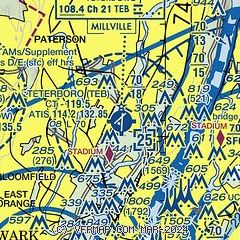
|
CAUTION: Diagram may not be current
 Download PDF
of official airport diagram from the FAA
| Airport distance calculator |
|---|
|
|
| Sunrise and sunset |
|---|
|
Times for 20-Apr-2024
| | Local
(UTC-4) | | Zulu
(UTC) |
|---|
| Morning civil twilight | | 05:40 | | 09:40 |
| Sunrise | | 06:09 | | 10:09 |
| Sunset | | 19:41 | | 23:41 |
| Evening civil twilight | | 20:10 | | 00:10 |
|
| Current date and time |
|---|
| Zulu (UTC) | 20-Apr-2024 08:51:07 |
|---|
| Local (UTC-4) | 20-Apr-2024 04:51:07 |
|---|
|
| METAR |
|---|
| KTEB | 200751Z 19005KT 10SM OVC010 09/07 A2997 RMK AO2 SLP148 T00940072
|
KNYC
6nm SE | 200751Z AUTO 00000KT 10SM OVC013 11/07 A3000 RMK AO2 SLP150 T01060072 $
|
KLGA
9nm SE | 200751Z 19005KT 10SM OVC009 09/07 A2998 RMK AO2 SLP151 T00940067
|
KJRB
9nm S | 200756Z AUTO 17005KT 10SM OVC008 09/07 A2999 RMK AO2 SLP155 T00940072 PNO $
|
KCDW
10nm W | 200753Z AUTO 00000KT 9SM OVC007 10/07 A2998 RMK AO2 SLP158 T01000067
|
KEWR
11nm SW | 200751Z 14004KT 8SM OVC008 10/08 A2997 RMK AO2 RAE01 SLP149 P0000 T01000078
|
KLDJ
16nm SW | 200835Z AUTO 00000KT 10SM OVC009 10/07 A2999 RMK AO2 T00960073
|
KMMU
17nm W | 200835Z AUTO 00000KT 2 1/2SM RA OVC004 09/08 A2997 RMK AO2
|
KJFK
19nm SE | 200751Z 20006KT 7SM BKN004 OVC006 09/08 A3000 RMK AO2 SLP157 T00890078
|
|
| TAF |
|---|
| KTEB | 200520Z 2006/2112 VRB04KT P6SM SCT008 OVC010 FM200800 VRB03KT 3SM -SHRA BR OVC006 FM201100 26005KT 6SM -SHRA BR BKN009 OVC015 FM201400 27008KT P6SM SCT100 SCT250 FM201800 27010G20KT P6SM SCT100 SCT250 FM202200 33012G24KT P6SM SCT250 FM210600 30011KT P6SM SCT150
|
KLGA
9nm SE | 200520Z 2006/2112 18005KT P6SM BKN008 OVC010 FM200900 18005KT 4SM -SHRA BR OVC007 FM201200 25007KT 5SM -SHRA BR SCT009 OVC015 FM201500 27007KT P6SM BKN080 FM201900 25011G20KT P6SM SCT100 SCT250 FM202200 32014G25KT P6SM SCT250 FM210600 30011KT P6SM SCT150
|
KEWR
11nm SW | 200520Z 2006/2112 16004KT P6SM OVC009 FM200800 21004KT 3SM -SHRA BR OVC006 FM201100 25005KT 6SM -SHRA BR BKN010 OVC015 FM201400 27008KT P6SM BKN060 FM201800 26012G21KT P6SM SCT100 SCT250 FM202200 32016G25KT P6SM SCT250 FM210600 30011KT P6SM SCT150
|
KJFK
19nm SE | 200520Z 2006/2112 16006KT P6SM BKN007 OVC015 FM200900 22006KT 3SM -SHRA BR OVC006 FM201200 25007KT 5SM -SHRA BR SCT008 OVC015 FM201500 26010KT P6SM BKN080 FM201900 24012G18KT P6SM SCT100 SCT250 FM202200 32014G21KT P6SM SCT250 FM210600 30011KT P6SM SCT150
|
|
| NOTAMs |
|---|
NOTAMs are issued by the DoD/FAA and will open in a separate window not controlled by AirNav.
|
|
FBO, Fuel Providers, and Aircraft Ground Support |
|---|
| | 
Business Name | |
Contact | |
Services / Description | |
Fuel Prices | |
Comments | |
|---|


|
|
ASRI 131.425
201-462-4000
toll-free 800-538-0832
[web site]
[email] |
|
Aviation fuel, Aircraft parking (ramp or tiedown), Passenger terminal and lounge, Aircraft charters, Aircraft maintenance, Avionics sales and service


|
|
|
|

write
|
|
 |
|
ASRI 130.15
201-393-4041
[web site]
[email] |
|
Head over to the East terminal for any of your FBO services.
Teterboro Airport is a general aviation reliever airport located in affluent Bergen County, New Jersey. Only twelve miles (19 km) from midtown Manhattan, access to New York City from Teterboro Airport is primarily available through the renowned George Washington Bridge to the north or a short distance south to the Lincoln Tunnel.
|
|
 | | 100LL | Jet A | | FS | | $8.80 | | $9.08 | | Updated 19-Apr-2024 |
|
|
write
|
|
 |
|
ASRI 132.00
201-288-1740
201-288-8275
[web site]
[email] |
|
Atlantic Aviation is your premier aviation service provider with more than 100 locations in North America, including Hawaii and the Caribbean. We provide standard ground services you'd expect, with a detailed focus on ensuring an unforgettable customer experience.

|
|
| | 100LL | Jet A | | FS | | $7.64 | | $9.08 | | Updated 19-Apr-2024 |
|
|
1 read write
|
|

|
|
ASRI 131.525
201-288-5040
[web site]
[email] |
|
Signature Aviation, the world's largest private aviation terminal operator, has acquired Meridian, an award-winning private aviation company with bases in Teterboro, NJ (TEB) and Hayward, CA (HWD).


|
|
|
|
3 read write
|
|
|
|
|
ASRI 130.60
201-288-3555
[web site]
[email] |
|
The South terminal location was recently built in the last 8 years, and offers customers a state of the art FBO terminal.
Teterboro Airport is a general aviation reliever airport located in affluent Bergen County, New Jersey. Only twelve miles (19 km) from midtown Manhattan, access to New York City from Teterboro Airport is primarily available through the renowned George Washington Bridge to the north or a short distance south to the Lincoln Tunnel.
|
|
| | Jet A | | FS | | $9.28 | | Updated 18-Apr-2024 |
|
|
1 read write
|
|
| Signature Aviation (west) |
|
201-288-1880
[web site]
[email] |
|
Aviation fuel, Aircraft parking (ramp or tiedown), Hangars, Passenger terminal and lounge, Aircraft maintenance, Catering, Courtesy transportation, Public telephone, ...
|
|
| independent | | 100LL | Jet A | | FS | | $8.80 | | $9.08 | | Updated 19-Apr-2024 |
|
|
write
|
|

|
| |
Aviation Businesses, Services, and Facilities |
|---|
| |
Business Name | |
Contact | |
Services / Description | |
Distance | |
Comments | |
|---|
 |
|
toll-free 877-296-8391
[web site]
[email] |
|
Aircraft cleaning / washing / detailing
|
|
on airport |
|
write
|
|
|
|
|
973-775-2919
[web site]
[email]

|
|
Oxygen service, Aircraft maintenance, Avionics sales and service, Aircraft modifications, Aircraft interiors, Aircraft parts, Aircraft management
|
|
on airport |
|
write
|
|
|
|
|
toll-free 844-453-8349
[web site]
[email] |
|
Aircraft maintenance, Avionics sales and service
|
|
on airport |
|
write
|
|
| |
Things to do: Attractions on or near the airport |
|---|
| |
Business Name | |
Contact | |
Services / Description | |
Distance | |
Comments | |
|---|
| Aviation Hall of Fame and Museum of New Jersey |
|
201-288-6344
|
|
no information available
If you are affiliated with Aviation Hall of Fame and Museum of New Jersey and would like to show here your services, contact info, web link, logo, and more, click here
|
|
on airport |
|
write
|
|
| |
Would you like to see your business listed on this page? |
|---|
| | If your business provides an interesting product or service to pilots, flight crews, aircraft, or users of the Teterboro Airport, you should consider listing it here. To start the listing process, click on the button below

|


