FAA INFORMATION EFFECTIVE 18 APRIL 2024
Location
| FAA Identifier: | RMG |
| Lat/Long: | 34-21-02.8000N 085-09-31.2000W
34-21.046667N 085-09.520000W
34.3507778,-85.1586667
(estimated) |
| Elevation: | 644.1 ft. / 196.3 m (surveyed) |
| Variation: | 02W (1985) |
| From city: | 6 miles N of ROME, GA |
| Time zone: | UTC -4 (UTC -5 during Standard Time) |
| Zip code: | 30165 |
Airport Operations
| Airport use: | Open to the public |
| Activation date: | 03/1944 |
| Control tower: | no |
| ARTCC: | ATLANTA CENTER |
| FSS: | MACON FLIGHT SERVICE STATION |
| NOTAMs facility: | RMG (NOTAM-D service available) |
| Attendance: | MON-FRI 0700-2000, ALL SAT-SUN 0900-1800 |
| Wind indicator: | lighted |
| Segmented circle: | yes |
| Lights: | ACTVT MALSR RWY 01; PAPI RWY 01 & 19; HIRL RWY 01/19 - CTAF. |
| Beacon: | white-green (lighted land airport)
Operates sunset to sunrise. |
Airport Communications
| CTAF/UNICOM: | 122.725 |
| WX ASOS: | 119.925 (706-235-3335) |
| WX AWOS-3 at CZL (13 nm NE): | 119.975 (706-602-5906) |
- APCH/DEP SVC PRVDD BY ATLANTA ARTCC ON FREQS 124.5/270.325 (GADSDEN RCAG).
Nearby radio navigation aids
| VOR radial/distance | | VOR name | | Freq | | Var |
|---|
| RMGr349/11.5 | | ROME VORTAC | | 115.40 | | 01E |
Airport Services
| Fuel available: | 100LL JET-A+ |
| Parking: | tiedowns |
| Airframe service: | MAJOR |
| Powerplant service: | MAJOR |
| Bottled oxygen: | NONE |
| Bulk oxygen: | NONE |
Runway Information
Runway 1/19
| Dimensions: | 6006 x 150 ft. / 1831 x 46 m |
| Surface: | asphalt/grooved, in good condition |
| Weight bearing capacity: | | Single wheel: | 52.0 | | Double wheel: | 57.0 | | Double tandem: | 114.0 |
|
| Runway edge lights: | high intensity |
| RUNWAY 1 | | RUNWAY 19 |
| Latitude: | 34-20.565880N | | 34-21.552292N |
| Longitude: | 085-09.567163W | | 085-09.464227W |
| Elevation: | 632.3 ft. | | 624.4 ft. |
| Traffic pattern: | left | | left |
| Runway heading: | 007 magnetic, 005 true | | 187 magnetic, 185 true |
| Markings: | precision, in fair condition | | precision, in fair condition |
| Visual slope indicator: | 4-light PAPI on left (3.00 degrees glide path) | | 4-light PAPI on left (3.00 degrees glide path) |
| Approach lights: | MALSR: 1,400 foot medium intensity approach lighting system with runway alignment indicator lights | | |
| Runway end identifier lights: | | | no |
| Touchdown point: | yes, no lights | | yes, no lights |
| Instrument approach: | ILS/DME | | |
| Obstructions: | 106 ft. trees, 2867 ft. from runway, 666 ft. right of centerline, 25:1 slope to clear | | 136 ft. trees, 4562 ft. from runway, 340 ft. right of centerline, 32:1 slope to clear |
Runway 7/25
| Dimensions: | 4495 x 100 ft. / 1370 x 30 m |
| Surface: | asphalt, in excellent condition |
| Weight bearing capacity: | | Single wheel: | 16.0 | | Double wheel: | 30.0 |
|
| RUNWAY 7 | | RUNWAY 25 |
| Latitude: | 34-20.903548N | | 34-21.157723N |
| Longitude: | 085-09.945853W | | 085-09.106550W |
| Elevation: | 644.1 ft. | | 626.0 ft. |
| Traffic pattern: | left | | left |
| Runway heading: | 072 magnetic, 070 true | | 252 magnetic, 250 true |
| Displaced threshold: | 115 ft. | | no |
| Declared distances: | TORA:4495 TODA:4495 ASDA:4495 LDA:4380 | | TORA:4495 TODA:4495 ASDA:4495 LDA:4495 |
| Markings: | nonprecision, in good condition | | nonprecision, in good condition |
| Touchdown point: | yes, no lights | | yes, no lights |
| Obstructions: | 15 ft. road, 260 ft. from runway, 300 ft. right of centerline, 4:1 slope to clear
RWY 07 - APCH RATIO 13:1 AT DSPLCD THLD; 67 FT TREES 1071 FT FM DSPLCD THLD 350 FT L. | | 51 ft. tree, 975 ft. from runway, 361 ft. left of centerline, 15:1 slope to clear |
Airport Ownership and Management from official FAA records
| Ownership: | Publicly-owned |
| Owner: | FLOYD COUNTY
PO BOX 946
ROME, GA 30161
Phone 706-295-7835 |
| Manager: | JOHN CARROLL
304 RUSSELL FIELD RD NE
ROME, GA 30161
Phone 706-295-7835 |
Airport Operational Statistics
| Aircraft based on the field: | | 69 | | Single engine airplanes: | | 56 | | Multi engine airplanes: | | 11 | | Jet airplanes: | | 1 | | Ultralights: | | 1 |
| |  | |
| Aircraft operations: avg 167/day * | | 49% | transient general aviation | | 49% | local general aviation | | 2% | military | | * for 12-month period ending 31 December 2022 | |
Additional Remarks
| - | ULTRALIGHT ACTIVITY ON & INVOF ARPT. |
| - | DEER ON INVOF ARPT. |
| - | MIL AIR CARGO DROP (C130 ACFT) IN PROGRESS 1830-2030 TUE AND THU AT NE END OF RWY 07/25. |
| - | GCO AVBL ON FREQ 121.725 THRU ATL CLEARANCE DELIVERY. |
| - | FOR CD IF UNA TO CTC ON FSS FREQ, CTC ATLANTA ARTCC AT 770-210-7692. |
Instrument Procedures
NOTE: All procedures below are presented as PDF files. If you need a reader for these files, you should download the free Adobe Reader.NOT FOR NAVIGATION. Please procure official charts for flight.
FAA instrument procedures published for use from 18 April 2024 at 0901Z to 16 May 2024 at 0900Z.
IAPs - Instrument Approach Procedures |
|---|
| ILS OR LOC RWY 01 | |
download (255KB) |
| RNAV (GPS) RWY 01 | |
download (243KB) |
| RNAV (GPS) RWY 07 | |
download (210KB) |
| RNAV (GPS) RWY 19 | |
download (233KB) |
| RNAV (GPS) RWY 25 | |
download (215KB) |
| NOTE: Special Alternate Minimums apply | |
download (159KB) |
| NOTE: Special Take-Off Minimums/Departure Procedures apply | |
download (509KB) |
Other nearby airports with instrument procedures:
KCZL - Tom B David Field Airport (13 nm NE)
4A4 - Polk County Airport/Cornelius Moore Field (20 nm S)
KVPC - Cartersville Airport (21 nm SE)
9A5 - Barwick Lafayette Airport (21 nm N)
KDNN - Dalton Municipal Airport (26 nm NE)
|
|

Road maps at:
MapQuest
Bing
Google
| Aerial photo |
|---|
WARNING: Photo may not be current or correct
 Photo courtesy of AirNav, LLC
Photo taken 11-Sep-2012
looking northeast.
Photo courtesy of AirNav, LLC
Photo taken 11-Sep-2012
looking northeast.
Do you have a better or more recent aerial photo of Richard B. Russell Regional Airport - J.H. Towers Field that you would like to share? If so, please send us your photo.
|
| Sectional chart |
|---|
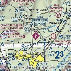
|
 Download PDF
of official airport diagram from the FAA
| Airport distance calculator |
|---|
|
|
| Sunrise and sunset |
|---|
|
Times for 25-Apr-2024
| | Local
(UTC-4) | | Zulu
(UTC) |
|---|
| Morning civil twilight | | 06:31 | | 10:31 |
| Sunrise | | 06:57 | | 10:57 |
| Sunset | | 20:20 | | 00:20 |
| Evening civil twilight | | 20:46 | | 00:46 |
|
| Current date and time |
|---|
| Zulu (UTC) | 25-Apr-2024 13:44:49 |
|---|
| Local (UTC-4) | 25-Apr-2024 09:44:49 |
|---|
|
| METAR |
|---|
| KRMG | 251253Z AUTO 06003KT 10SM CLR 13/09 A3019 RMK AO2 SLP218 T01280089
|
KCZL
13nm NE | 251335Z AUTO 00000KT 10SM CLR 16/09 A3020 RMK AO2
|
|
| TAF |
|---|
KRYY
34nm SE | 251126Z 2512/2612 00000KT P6SM SKC FM251300 VRB03KT P6SM SKC FM251600 31004KT P6SM FEW250 FM251900 29005KT P6SM BKN250 FM260100 00000KT P6SM FEW120 BKN200 FM260800 00000KT P6SM SCT050 BKN100
|
KCHA
41nm N | 251120Z 2512/2612 VRB05KT P6SM SCT250 FM260800 VRB03KT P6SM VCSH OVC100
|
KMGE
41nm SE | 251100Z 2511/2603 VRB05KT 9999 FEW250 QNH3004INS BECMG 2517/2518 09005KT 9999 FEW060 BKN250 QNH3010INS TX26/2520Z TN12/2512Z
|
|
| NOTAMs |
|---|
NOTAMs are issued by the DoD/FAA and will open in a separate window not controlled by AirNav.
|
|


