FAA INFORMATION EFFECTIVE 18 APRIL 2024
Location
| FAA Identifier: | 35A |
| Lat/Long: | 34-41-13.0300N 081-38-28.2000W
34-41.217167N 081-38.470000W
34.6869528,-81.6411667
(estimated) |
| Elevation: | 610.2 ft. / 186 m (estimated) |
| Variation: | 06W (2000) |
| From city: | 1 mile SW of UNION, SC |
| Time zone: | UTC -4 (UTC -5 during Standard Time) |
| Zip code: | 29379 |
Airport Operations
| Airport use: | Open to the public |
| Activation date: | 09/1970 |
| Control tower: | no |
| ARTCC: | ATLANTA CENTER |
| FSS: | ANDERSON FLIGHT SERVICE STATION |
| NOTAMs facility: | AND (NOTAM-D service available) |
| Attendance: | MON-FRI 0800-1700 |
| Wind indicator: | lighted |
| Segmented circle: | yes |
| Lights: | MIRL RY 05/23 PRESET MED INTST DUSK-0000; AFTER 0000 ACTVT - CTAF. ACTVT PAPI RYS 05 & 23 - CTAF. |
| Beacon: | white-green (lighted land airport)
Operates sunset to sunrise. |
Airport Communications
| CTAF/UNICOM: | 122.7 |
| WX AWOS-3PT: | 119.45 (864-427-1514) |
| GREER APPROACH: | 119.4 [OPR 1100-0300Z++] |
| GREER DEPARTURE: | 119.4 [OPR 1100-0300Z++] |
| WX AWOS-3 at LUX (19 nm SW): | 123.975 (864-682-3639) |
- APCH/DEP SVC PRVDD BY ATLANTA ARTCC ON FREQS 135.35/263.125 (OWING RCAG) WHEN APCH CTL CLSD.
Nearby radio navigation aids
| VOR radial/distance | | VOR name | | Freq | | Var |
|---|
| SPAr148/25.1 | | SPARTANBURG VORTAC | | 115.70 | | 02W |
| NDB name | | Hdg/Dist | | Freq | | Var | | ID |
|---|
| UNION COUNTY | | at field | | 326 | | 06W | | UOT | ..- --- - |
| CHESTER | | 261/22.5 | | 220 | | 06W | | DCM | -.. -.-. -- |
| ENOREE | | 006/22.6 | | 278 | | 07W | | EOE | . --- . |
| FIRST RIVER | | 190/34.0 | | 417 | | 06W | | SLP | ... .-.. .--. |
| STONIA | | 224/38.5 | | 260 | | 06W | | GHJ | --. .... .--- |
Airport Services
| Fuel available: | 100LL
100LL:SELF-SERVE FUEL AVBL 24 HRS. FOR SVC AFT HRS CALL 864-426-3003. |
| Parking: | hangars and tiedowns |
| Airframe service: | MAJOR |
| Powerplant service: | MAJOR |
| Bottled oxygen: | NONE |
| Bulk oxygen: | NONE |
Runway Information
Runway 5/23
| Dimensions: | 3508 x 60 ft. / 1069 x 18 m |
| Surface: | asphalt, in good condition |
| Weight bearing capacity: | |
| Runway edge lights: | medium intensity |
| RUNWAY 5 | | RUNWAY 23 |
| Latitude: | 34-41.020500N | | 34-41.413833N |
| Longitude: | 081-38.726667W | | 081-38.213333W |
| Elevation: | 573.4 ft. | | 610.0 ft. |
| Traffic pattern: | left | | left |
| Runway heading: | 053 magnetic, 047 true | | 233 magnetic, 227 true |
| Markings: | nonprecision, in good condition | | basic, in good condition |
| Visual slope indicator: | 2-light PAPI on left (4.00 degrees glide path) | | 2-light PAPI on left (4.00 degrees glide path) |
| Touchdown point: | yes, no lights | | yes, no lights |
| Obstructions: | 14 ft. tree, 211 ft. from runway, 89 ft. left of centerline, 1:1 slope to clear
TREES CLOSE-IN, 142 FT FROM RWY END BOTH SIDES OF RWY 5 APCH 112 FT FROM CNTRLN. | | none |
Airport Ownership and Management from official FAA records
| Ownership: | Publicly-owned |
| Owner: | UNION COUNTY
PO DRAWER G
UNION, SC 29379
Phone 864-429-1600 |
| Manager: | RONNIE WADE
UNION COUNTY AIRPORT, 198 AIRPORT RD
UNION, SC 29379
Phone 864-429-1680 |
Airport Operational Statistics
| Aircraft based on the field: | | 12 | | Single engine airplanes: | | 10 | | Gliders airplanes: | | 1 | | Ultralights: | | 1 |
| |  | |
| Aircraft operations: avg 57/week * | | 56% | transient general aviation | | 44% | local general aviation | | * for 12-month period ending 14 June 2022 | |
Additional Remarks
| - | FOR CD CTC GREER APCH AT 864-877-8275. WHEN GREER APCH CLSD, FOR CD CTC ATLANTA ARTCC AT 770-210-7692. |
Instrument Procedures
NOTE: All procedures below are presented as PDF files. If you need a reader for these files, you should download the free Adobe Reader.NOT FOR NAVIGATION. Please procure official charts for flight.
FAA instrument procedures published for use from 18 April 2024 at 0901Z to 16 May 2024 at 0900Z.
IAPs - Instrument Approach Procedures |
|---|
| RNAV (GPS) RWY 05 | |
download (201KB) |
| RNAV (GPS) RWY 23 | |
download (203KB) |
| NOTE: Special Take-Off Minimums/Departure Procedures apply | |
download (364KB) |
Other nearby airports with instrument procedures:
KLUX - Laurens County Airport (19 nm SW)
KSPA - Spartanburg Downtown Memorial Airport/Simpson Field (21 nm NW)
KEOE - Newberry County Airport (23 nm S)
KDCM - Chester Catawba Regional Airport (23 nm E)
KGSP - Greenville Spartanburg International Airport (31 nm NW)
|
|

Road maps at:
MapQuest
Bing
Google
| Aerial photo |
|---|
WARNING: Photo may not be current or correct

Do you have a better or more recent aerial photo of Union County Airport, Troy Shelton Field that you would like to share? If so, please send us your photo.
|
| Sectional chart |
|---|
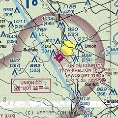
|
| Airport distance calculator |
|---|
|
|
| Sunrise and sunset |
|---|
|
Times for 24-Apr-2024
| | Local
(UTC-4) | | Zulu
(UTC) |
|---|
| Morning civil twilight | | 06:17 | | 10:17 |
| Sunrise | | 06:44 | | 10:44 |
| Sunset | | 20:05 | | 00:05 |
| Evening civil twilight | | 20:32 | | 00:32 |
|
| Current date and time |
|---|
| Zulu (UTC) | 24-Apr-2024 15:10:05 |
|---|
| Local (UTC-4) | 24-Apr-2024 11:10:05 |
|---|
|
| METAR |
|---|
KLUX
19nm SW | 241455Z AUTO 25007KT 10SM CLR 20/09 A3008 RMK AO2
|
KEOE
23nm S | 241455Z AUTO 22010KT 10SM CLR 20/09 A3011 RMK AO2
|
KDCM
23nm E | 241455Z AUTO 24005KT 10SM CLR 19/08 A3009 RMK AO2
|
KSPA
25nm NW | 241455Z AUTO 26004KT 10SM CLR 20/08 A3007 RMK AO2
|
KGSP
31nm NW | 241453Z 25006KT 10SM CLR 21/07 A3006 RMK AO2 SLP173 T02060067 53001
|
KUZA
34nm NE | 241454Z AUTO 10SM CLR 19/09 A3007 RMK AO2 SLP177 T01940094 53003
|
KEHO
34nm N | 241445Z AUTO 21003KT 10SM CLR 19/08 A3006 RMK AO2 T01870084
|
KFDW
34nm SE | 241455Z AUTO 25009KT 224V294 10SM CLR 21/09 A3008 RMK AO1
|
KGMU
36nm W | 241453Z 23008KT 10SM CLR 20/08 A3007 RMK AO2 SLP177 T02000083 53000
|
KGRD
36nm SW | 241456Z AUTO 24012KT 10SM FEW075 19/10 A3010 RMK AO2 SLP190 T01890100 55003 $
|
|
| TAF |
|---|
KGSP
31nm NW | 241120Z 2412/2512 23007KT P6SM FEW250 FM241500 25010KT P6SM SCT050 BKN120 FM242200 30008KT P6SM SCT100 BKN250 FM250300 35004KT P6SM FEW250
|
KGMU
36nm W | 241120Z 2412/2512 23007KT P6SM FEW250 FM241500 25010KT P6SM SCT050 BKN120 FM242200 30008KT P6SM SCT100 BKN250 FM250300 35004KT P6SM FEW250
|
|
| NOTAMs |
|---|
NOTAMs are issued by the DoD/FAA and will open in a separate window not controlled by AirNav.
|
|


