FAA INFORMATION EFFECTIVE 18 APRIL 2024
Location
| FAA Identifier: | 3B4 |
| Lat/Long: | 43-08-35.2835N 070-46-24.3700W
43-08.588058N 070-46.406167W
43.1431343,-70.7734361
(estimated) |
| Elevation: | 124.8 ft. / 38 m (estimated) |
| Variation: | 16W (1995) |
| From city: | 2 miles SE of ELIOT, ME |
| Time zone: | UTC -4 (UTC -5 during Standard Time) |
| Zip code: | 03903 |
Airport Operations
| Airport use: | Open to the public |
| Activation date: | 08/1966 |
| Control tower: | no |
| ARTCC: | BOSTON CENTER |
| FSS: | BANGOR FLIGHT SERVICE STATION |
| NOTAMs facility: | BGR (NOTAM-D service available) |
| Attendance: | UNATNDD |
| Wind indicator: | yes |
| Segmented circle: | no |
Airport Communications
| CTAF: | 122.9 |
| BOSTON APPROACH: | 125.05 |
| BOSTON DEPARTURE: | 125.05 |
| IC: | 125.05 |
| WX ASOS at DAW (11 nm NW): | 135.275 (603-332-7814) |
| WX AWOS-3PT at SFM (15 nm N): | 120.025 (207-324-1958) |
Nearby radio navigation aids
| VOR radial/distance | | VOR name | | Freq | | Var |
|---|
| ENEr219/18.3 | | KENNEBUNK VOR/DME | | 117.10 | | 17W |
| MHTr073/30.9 | | MANCHESTER VOR/DME | | 114.40 | | 15W |
| CONr112/35.4 | | CONCORD VOR/DME | | 112.90 | | 15W |
| NDB name | | Hdg/Dist | | Freq | | Var | | ID |
|---|
| ROLLINS | | 169/5.2 | | 260 | | 16W | | ESG | . ... --. |
Airport Services
| Parking: | tiedowns |
| Airframe service: | NONE |
| Powerplant service: | NONE |
| Bottled oxygen: | NONE |
| Bulk oxygen: | NONE |
Runway Information
Runway 12/30
| Dimensions: | 2701 x 50 ft. / 823 x 15 m |
| Surface: | asphalt, in excellent condition |
| Weight bearing capacity: | |
| RUNWAY 12 | | RUNWAY 30 |
| Latitude: | 43-08.664617N | | 43-08.511500N |
| Longitude: | 070-46.691000W | | 070-46.121333W |
| Elevation: | 123.6 ft. | | 105.7 ft. |
| Traffic pattern: | left | | left |
| Runway heading: | 126 magnetic, 110 true | | 306 magnetic, 290 true |
| Displaced threshold: | no | | 86 ft. |
| Markings: | nonprecision, in good condition | | nonprecision, in good condition |
| Touchdown point: | yes, no lights | | yes, no lights |
| Obstructions: | 25 ft. trees, 201 ft. from runway, 60 ft. left of centerline
20-25 FT TREES AND BRUSH 0-200 FT FM THR, 115-125 FT L OF CNTRLN; 5-25 FT TREES 5-150 FT FM THR, 15-150 FT R OF CNTRLN AND 15-250 FT L OF CNTRLN. | | 30 ft. trees, 360 ft. from runway, 130 ft. right of centerline, 5:1 slope to clear
20 FT TREES 90-135 FT FM THR, 90 FT R OF CNTRLN; 23 FT HOUSE 68 FT FM THR, 118 FT L OF CNTRLN; 35 FT TREES 90 FT FM THR, 100 FT L OF CNTRLN. |
Airport Ownership and Management from official FAA records
| Ownership: | Privately-owned |
| Owner: | SHAMROCK AVIATION
380 LAFAYETTE RD, UNIT 11-209
SEABROOK, NH 03874
Phone 207-200-5019 |
| Manager: | THOMAS SHAUGHNESSY
380 LAFAYETTE RD, SUITE 11-209
SEABROOK, NH 03874
Phone 949-378-8405 |
Airport Operational Statistics
| Aircraft based on the field: | | 12 | | Single engine airplanes: | | 12 |
| |  | |
| Aircraft operations: avg 49/week * | | 98% | local general aviation | | 2% | transient general aviation | | * for 12-month period ending 14 August 2023 | |
Additional Remarks
| - | BIRDS & DEER ON & INVOF ARPT. |
| - | FOR CD CTC BOSTON APCH AT 603-594-5551. |
Instrument Procedures
NOTE: All procedures below are presented as PDF files. If you need a reader for these files, you should download the free Adobe Reader.NOT FOR NAVIGATION. Please procure official charts for flight.
FAA instrument procedures published for use from 18 April 2024 at 0901Z to 16 May 2024 at 0900Z.
IAPs - Instrument Approach Procedures |
|---|
| RNAV (GPS) RWY 30 | |
download (198KB) |
| NOTE: Special Take-Off Minimums/Departure Procedures apply | |
download (510KB) |
Other nearby airports with instrument procedures:
KPSM - Portsmouth International Airport at Pease (4 nm SW)
KDAW - Skyhaven Airport (11 nm NW)
KSFM - Sanford Seacoast Regional Airport (15 nm N)
B19 - Biddeford Municipal Airport (23 nm NE)
KLWM - Lawrence Municipal Airport (30 nm SW)
|
|

Road maps at:
MapQuest
Bing
Google
| Aerial photo |
|---|
WARNING: Photo may not be current or correct
 Photo by Mya Dundzila
Photo taken 12-Nov-2018
looking west-northwest.
Photo by Mya Dundzila
Photo taken 12-Nov-2018
looking west-northwest.
Do you have a better or more recent aerial photo of Seacoast Airfield that you would like to share? If so, please send us your photo.
|
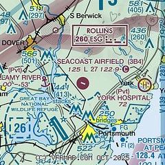
| Sectional chart |
|---|
|
| Airport distance calculator |
|---|
|
|
| Sunrise and sunset |
|---|
|
Times for 24-Apr-2024
| | Local
(UTC-4) | | Zulu
(UTC) |
|---|
| Morning civil twilight | | 05:16 | | 09:16 |
| Sunrise | | 05:46 | | 09:46 |
| Sunset | | 19:36 | | 23:36 |
| Evening civil twilight | | 20:06 | | 00:06 |
|
| Current date and time |
|---|
| Zulu (UTC) | 24-Apr-2024 04:13:02 |
|---|
| Local (UTC-4) | 24-Apr-2024 00:13:02 |
|---|
|
| METAR |
|---|
KPSM
5nm S | 240355Z 17006KT 10SM FEW120 BKN250 06/M04 A2996 RMK AO2A SLP148 T00631045
|
KDAW
10nm NW | 240351Z AUTO 17003KT 10SM CLR 07/M02 A2996 RMK AO2 SLP142 T00671022
|
KSFM
15nm N | 240356Z AUTO 00000KT 10SM CLR 02/M01 A2997 RMK AO2 SLP154 T00171006 401501056 FZRANO $
|
|
| TAF |
|---|
KPSM
5nm S | 231746Z 2318/2418 16012G20KT P6SM SKC FM240000 16007KT P6SM SKC FM240600 18006KT P6SM SCT080 FM241300 19008G16KT P6SM -SHRA SCT016 OVC040
|
|
| NOTAMs |
|---|
NOTAMs are issued by the DoD/FAA and will open in a separate window not controlled by AirNav.
|
|

