FAA INFORMATION EFFECTIVE 18 APRIL 2024
Location
| FAA Identifier: | 42A |
| Lat/Long: | 36-04-15.5290N 091-49-48.4880W
36-04.258817N 091-49.808133W
36.0709803,-91.8301356
(estimated) |
| Elevation: | 734.8 ft. / 224.0 m (surveyed) |
| Variation: | 01E (2005) |
| From city: | 3 miles E of MELBOURNE, AR |
| Time zone: | UTC -5 (UTC -6 during Standard Time) |
| Zip code: | 72556 |
Airport Operations
| Airport use: | Open to the public |
| Activation date: | 01/1994 |
| Control tower: | no |
| ARTCC: | MEMPHIS CENTER |
| FSS: | JONESBORO FLIGHT SERVICE STATION |
| NOTAMs facility: | JBR (NOTAM-D service available) |
| Attendance: | MON-SAT DAYLIGHT HOURS |
| Wind indicator: | lighted |
| Segmented circle: | yes |
| Lights: | ACTVT MIRL RWY 03/21 & REIL RWY 03/21 - CTAF |
| Beacon: | white-green (lighted land airport)
Operates sunset to sunrise. |
Airport Communications
| CTAF: | 122.9 |
| WX AWOS-3PT: | 121.575 (870-916-2768) |
- APCH/DEP SVC PRVDD BY MEMPHIS ARTCC ON FREQS 126.85/281.55 (HARRISON RCAG).
Airport Services
| Fuel available: | 100LL JET-A
100LL:SELF SERVE FUEL H24 WITH CREDIT CARD. |
| Parking: | hangars and tiedowns |
| Airframe service: | MAJOR |
| Powerplant service: | MAJOR |
Runway Information
Runway 3/21
| Dimensions: | 4003 x 75 ft. / 1220 x 23 m
150 FT PAVED STOPWAY EACH END - FULL STRENGTH. |
| Surface: | asphalt, in good condition |
| Runway edge lights: | medium intensity |
| RUNWAY 3 | | RUNWAY 21 |
| Latitude: | 36-03.978357N | | 36-04.539282N |
| Longitude: | 091-50.021917W | | 091-49.594318W |
| Elevation: | 734.8 ft. | | 708.9 ft. |
| Traffic pattern: | left | | left |
| Runway heading: | 031 magnetic, 032 true | | 211 magnetic, 212 true |
| Markings: | nonprecision, in good condition | | nonprecision, in good condition |
| Visual slope indicator: | 2-light PAPI on left (3.00 degrees glide path) | | 2-light PAPI on left (3.00 degrees glide path) |
| Runway end identifier lights: | yes | | yes |
| Touchdown point: | yes, no lights | | yes, no lights |
| Obstructions: | 42 ft. tree, 1800 ft. from runway, 465 ft. right of centerline, 38:1 slope to clear | | 50 ft. tree, 1550 ft. from runway, 425 ft. left of centerline, 27:1 slope to clear |
Airport Ownership and Management from official FAA records
| Ownership: | Publicly-owned |
| Owner: | CITY OF MELBOURNE
PO BOX 800
MELBOURNE, AR 72556
Phone 870-368-4215 |
| Manager: | KEN CLARK
P.O. BOX 800
MELBOURNE, AR 72556
Phone (870) 291-1227 |
Airport Operational Statistics
| Aircraft based on the field: | | 24 | | Single engine airplanes: | | 22 | | Multi engine airplanes: | | 2 |
| |  | |
| Aircraft operations: avg 178/day * | | 92% | local general aviation | | 8% | transient general aviation | | <1% | military | | * for 12-month period ending 31 January 2022 | |
Additional Remarks
| - | FOR CD CTC MEMPHIS ARTCC AT 901-368-8453/8449. |
Instrument Procedures
NOTE: All procedures below are presented as PDF files. If you need a reader for these files, you should download the free Adobe Reader.NOT FOR NAVIGATION. Please procure official charts for flight.
FAA instrument procedures published for use from 18 April 2024 at 0901Z to 16 May 2024 at 0900Z.
IAPs - Instrument Approach Procedures |
|---|
| RNAV (GPS) RWY 03 | |
download (200KB) |
| RNAV (GPS) RWY 21 | |
download (191KB) |
| NOTE: Special Take-Off Minimums/Departure Procedures apply | |
download (391KB) |
Other nearby airports with instrument procedures:
6M2 - Horseshoe Bend Airport (10 nm N)
KCVK - Sharp County Regional Airport (17 nm NE)
7M2 - Mountain View Airport-Wilcox Memorial Field (18 nm SW)
KBVX - Batesville Regional Airport (23 nm SE)
KHBZ - Heber Springs Municipal Airport (35 nm S)
|
|

Road maps at:
MapQuest
Bing
Google
| Aerial photo |
|---|
WARNING: Photo may not be current or correct
 Photo courtesy of the Arkansas Department of Aeronautics
Taken in the Spring of 2007
Photo courtesy of the Arkansas Department of Aeronautics
Taken in the Spring of 2007
Do you have a better or more recent aerial photo of Melbourne Municipal Airport - John E Miller Field that you would like to share? If so, please send us your photo.
|
| Sectional chart |
|---|
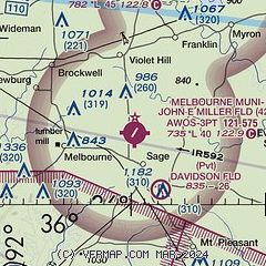
|
| Airport distance calculator |
|---|
|
|
| Sunrise and sunset |
|---|
|
Times for 25-Apr-2024
| | Local
(UTC-5) | | Zulu
(UTC) |
|---|
| Morning civil twilight | | 05:54 | | 10:54 |
| Sunrise | | 06:21 | | 11:21 |
| Sunset | | 19:49 | | 00:49 |
| Evening civil twilight | | 20:16 | | 01:16 |
|
| Current date and time |
|---|
| Zulu (UTC) | 25-Apr-2024 10:53:16 |
|---|
| Local (UTC-5) | 25-Apr-2024 05:53:16 |
|---|
|
| METAR |
|---|
KBVX
23nm S | 250956Z AUTO 07004KT 10SM SCT120 13/09 A3015 RMK AO2 SLP209 T01280089
|
KFLP
33nm NW | 250956Z AUTO 12003KT 10SM SCT120 13/08 A3015 RMK AO2 SLP204 T01280078 $
|
KBPK
36nm NW | 250953Z AUTO 11009KT 10SM FEW110 12/06 A3013 RMK AO2 SLP197 T01220061
|
KM19
41nm SE | 250956Z AUTO 07008KT 10SM BKN120 14/08 A3016 RMK AO2 SLP212 T01440078 $
|
KCCA
41nm SW | 251035Z AUTO 00000KT 10SM BKN100 13/12 A3012 RMK AO2 TSNO
|
KARG
44nm E | 250956Z AUTO 05009KT 10SM SCT110 13/09 A3018 RMK AO2 SLP218 T01280089
|
|
| TAF |
|---|
KBPK
36nm NW | 250536Z 2506/2606 09004KT P6SM SCT250 FM250700 12004KT P6SM VCSH BKN050 OVC100 FM251400 12010KT P6SM VCSH OVC030 FM251700 13012KT 6SM -SHRA BR OVC015 FM252000 13011KT 4SM -RA BR OVC007
|
|
| NOTAMs |
|---|
NOTAMs are issued by the DoD/FAA and will open in a separate window not controlled by AirNav.
|
|

