FAA INFORMATION EFFECTIVE 18 APRIL 2024
Location
| FAA Identifier: | BAZ |
| Lat/Long: | 29-42-20.7000N 098-02-35.6000W
29-42.345000N 098-02.593333W
29.7057500,-98.0432222
(estimated) |
| Elevation: | 658.4 ft. / 200.7 m (surveyed) |
| Variation: | 08E (1975) |
| From city: | 4 miles E of NEW BRAUNFELS, TX |
| Time zone: | UTC -5 (UTC -6 during Standard Time) |
| Zip code: | 78130 |
Airport Operations
| Airport use: | Open to the public |
| Activation date: | 09/1944 |
| Control tower: | yes |
| ARTCC: | HOUSTON CENTER |
| FSS: | SAN ANGELO FLIGHT SERVICE STATION |
| NOTAMs facility: | BAZ (NOTAM-D service available) |
| Attendance: | 0700-1900 |
| Wind indicator: | lighted |
| Segmented circle: | yes |
| Lights: | ACTVT MIRL RWY 13/31, RWY 17/35 - CTAF. |
| Beacon: | white-green (lighted land airport)
Operates sunset to sunrise. |
Airport Communications
| CTAF: | 127.05 |
| UNICOM: | 122.7 |
| ATIS: | 119.325 |
| WX ASOS: | 119.325 (830-629-7979) |
| NEW BRAUNFELS GROUND: | 120.175 [0700-1900] |
| NEW BRAUNFELS TOWER: | 127.05 285.4 [0700-1900] |
| SAN ANTONIO APPROACH: | 124.45 |
| SAN ANTONIO DEPARTURE: | 128.05 |
| CLEARANCE DELIVERY: | 134.75 134.75 ; WHEN BAZ TWR CLSD. |
| CRVZA RNAV STAR: | 125.7 |
| DNKIN RNAV STAR: | 125.1 |
| POPPO RNAV STAR: | 125.1 |
| QERVO RNAV STAR: | 127.1 |
| WX AWOS-3PT at HYI (15 nm NE): | PHONE 512-353-8005 |
Nearby radio navigation aids
| VOR radial/distance | | VOR name | | Freq | | Var |
|---|
| RNDr043/16.9 | | RANDOLPH VORTAC | | 112.30 | | 05E |
| SATr072/22.1 | | SAN ANTONIO VORTAC | | 116.80 | | 08E |
| SSFr029/(34.0) | | STINSON VOR | | 108.40 | | 09E |
Airport Services
| Fuel available: | 100LL JET-A JET-A+
100LL:FUEL 24 HR SELF SVC. FOR FULL SERVE FUEL CALL 830-221-4290; AFT HRS CALL 830-221-4100. |
| Parking: | hangars and tiedowns |
| Airframe service: | MAJOR |
| Powerplant service: | MAJOR |
Runway Information
Runway 13/31
| Dimensions: | 6503 x 100 ft. / 1982 x 30 m |
| Surface: | asphalt, in good condition |
| Weight bearing capacity: | | Single wheel: | 30.0 | | Double wheel: | 60.0 |
|
| Runway edge lights: | medium intensity |
| RUNWAY 13 | | RUNWAY 31 |
| Latitude: | 29-42.906600N | | 29-42.138333N |
| Longitude: | 098-02.996432W | | 098-02.138667W |
| Elevation: | 658.4 ft. | | 643.5 ft. |
| Traffic pattern: | left | | left |
| Runway heading: | 128 magnetic, 136 true | | 308 magnetic, 316 true |
| Markings: | nonprecision, in good condition | | nonprecision, in good condition |
| Visual slope indicator: | 4-light PAPI on left (3.00 degrees glide path) | | 4-light PAPI on left (3.00 degrees glide path) |
| Approach lights: | MALS: 1,400 foot medium intensity approach lighting system | | |
| Runway end identifier lights: | yes | | |
| Touchdown point: | yes, no lights | | yes, no lights |
Runway 17/35
| Dimensions: | 5364 x 100 ft. / 1635 x 30 m |
| Surface: | asphalt, in fair condition |
| Weight bearing capacity: | |
| Runway edge lights: | medium intensity |
| RUNWAY 17 | | RUNWAY 35 |
| Latitude: | 29-42.570987N | | 29-41.686108N |
| Longitude: | 098-02.618000W | | 098-02.630515W |
| Elevation: | 646.6 ft. | | 644.5 ft. |
| Traffic pattern: | left | | left |
| Runway heading: | 173 magnetic, 181 true | | 353 magnetic, 001 true |
| Displaced threshold: | 522 ft. | | no |
| Markings: | nonprecision, in fair condition | | nonprecision, in fair condition |
| Touchdown point: | yes, no lights | | yes, no lights |
| Obstructions: | none
APCH RATIO 50:1 AT DSPLCD THR. | | 45 ft. pline, 1300 ft. from runway, 388 ft. right of centerline, 24:1 slope to clear |
Airport Ownership and Management from official FAA records
| Ownership: | Publicly-owned |
| Owner: | CITY OF NEW BRAUNFELS
550 LANDA ST.
NEW BRAUNFELS, TX 78130
Phone (830) 221-4000 |
| Manager: | ROBERT LEE
2333 FM 758
NEW BRAUNFELS, TX 78130
Phone 830-221-4290 |
Airport Operational Statistics
| Aircraft based on the field: | | 156 | | Single engine airplanes: | | 124 | | Multi engine airplanes: | | 9 | | Jet airplanes: | | 19 | | Helicopters: | | 4 |
| |  | |
| Aircraft operations: avg 208/day * | | 53% | local general aviation | | 39% | transient general aviation | | 5% | air taxi | | 3% | military | | * for 12-month period ending 31 December 2023 | |
Additional Remarks
| - | BIRDS INVOF ARPT. |
| - | HIGH PER MIL ACFT OPRG AT RANDOLPH AFB AUX FLD (SEGUIN-SEQ). |
| - | FOR CD WHEN ATCT IS CLSD CTC SAT APCH AT 210-805-5516. |
Instrument Procedures
NOTE: All procedures below are presented as PDF files. If you need a reader for these files, you should download the free Adobe Reader.NOT FOR NAVIGATION. Please procure official charts for flight.
FAA instrument procedures published for use from 18 April 2024 at 0901Z to 16 May 2024 at 0900Z.
STARs - Standard Terminal Arrivals |
|---|
| CRVZA ONE (RNAV) | |
2 pages:
[1] [2] (301KB) |
| CRVZA ONE (RNAV), CONT.2 | |
download (205KB) |
| DNKIN ONE (RNAV) | |
2 pages:
[1] [2] (432KB) |
| POPPO ONE (RNAV) | |
2 pages:
[1] [2] (312KB) |
| POPPO ONE (RNAV), CONT.2 | |
download (235KB) |
| QERVO ONE (RNAV) | |
2 pages:
[1] [2] (391KB) |
| QERVO ONE (RNAV), CONT.2 | |
download (274KB) |
IAPs - Instrument Approach Procedures |
|---|
| RNAV (GPS) RWY 13 | |
download (297KB) |
| RNAV (GPS) RWY 17 | |
download (215KB) |
| RNAV (GPS) RWY 31 | |
download (273KB) |
| RNAV (GPS) RWY 35 | |
download (250KB) |
| VOR/DME-A | |
download (173KB) |
| NOTE: Special Alternate Minimums apply | |
download (115KB) |
Departure Procedures |
|---|
| ALISS SIX (RNAV) | |
download (164KB) |
| SLENA ONE (RNAV) | |
download (172KB) |
| SNIDR ONE (RNAV) | |
download (242KB) |
| TJANO ONE (RNAV) | |
download (187KB) |
| YODUH ONE (RNAV) | |
download (201KB) |
| NOTE: Special Take-Off Minimums/Departure Procedures apply | |
download (293KB) |
Other nearby airports with instrument procedures:
KHYI - San Marcos Regional Airport (15 nm NE)
KRND - Randolph Air Force Base (16 nm SW)
50R - Lockhart Municipal Airport (21 nm NE)
KSAT - San Antonio International Airport (24 nm SW)
KSSF - Stinson Municipal Airport (31 nm SW)
|
|

Road maps at:
MapQuest
Bing
Google
| Aerial photo |
|---|
WARNING: Photo may not be current or correct

Do you have a better or more recent aerial photo of New Braunfels National Airport that you would like to share? If so, please send us your photo.
|
| Sectional chart |
|---|
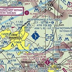
|
CAUTION: Diagram may not be current

| Airport distance calculator |
|---|
|
|
| Sunrise and sunset |
|---|
|
Times for 25-Apr-2024
| | Local
(UTC-5) | | Zulu
(UTC) |
|---|
| Morning civil twilight | | 06:30 | | 11:30 |
| Sunrise | | 06:55 | | 11:55 |
| Sunset | | 20:05 | | 01:05 |
| Evening civil twilight | | 20:30 | | 01:30 |
|
| Current date and time |
|---|
| Zulu (UTC) | 25-Apr-2024 17:19:19 |
|---|
| Local (UTC-5) | 25-Apr-2024 12:19:19 |
|---|
|
| METAR |
|---|
| KBAZ | 251701Z 15014G21KT 9SM SCT018 BKN035 OVC046 26/21 A2996 RMK AO2 T02610211
|
KSEQ
11nm SE | 251655Z AUTO 13011G17KT M M OVC016 25/22 A2995 RMK AO2 SLPNO T02510220 RVRNO PWINO TSNO $
|
KHYI
14nm NE | 251656Z 17014KT 10SM BKN020 OVC030 24/21 A2999 RMK AO2 SLP149 T02440211
|
KRND
16nm SW | 251655Z 17012G18KT 7SM BKN010 BKN015 OVC022 24/21 A2994 RMK AO2A BKN010 V OVC SLP132 T02390208 $
|
|
| TAF |
|---|
KRND
16nm SW | 251600Z 2516/2622 16012G18KT 9999 VCSH BKN012 OVC018 QNH2992INS TEMPO 2516/2518 SCT012 OVC018 BECMG 2517/2518 17015G25KT 9999 NSW SCT020 BKN030 OVC250 QNH2978INS TEMPO 2518/2520 BKN020 OVC035 BECMG 2602/2603 16015G25KT 9000 BR BKN009 OVC015 QNH2981INS BECMG 2605/2606 15012G20KT 8000 BR OVC006 QNH2976INS BECMG 2610/2611 17012G20KT 8000 -SHRA BR VCTS BKN006CB OVC010 QNH2976INS TEMPO 2612/2614 VRB20G35KT 4800 -TSRA OVC006CB BECMG 2614/2615 17012G22KT 9000 BR SCT007 OVC015 QNH2970INS BECMG 2620/2621
|
|
| NOTAMs |
|---|
NOTAMs are issued by the DoD/FAA and will open in a separate window not controlled by AirNav.
|
|


