FAA INFORMATION EFFECTIVE 18 APRIL 2024
Location
| FAA Identifier: | D52 |
| Lat/Long: | 42-47-55.2250N 077-50-33.0120W
42-47.920417N 077-50.550200W
42.7986736,-77.8425033
(estimated) |
| Elevation: | 560 ft. / 171 m (estimated) |
| Variation: | 11W (1985) |
| From city: | 1 mile W of GENESEO, NY |
| Time zone: | UTC -4 (UTC -5 during Standard Time) |
| Zip code: | 14454 |
Airport Operations
| Airport use: | Open to the public |
| Activation date: | 07/1969 |
| Control tower: | no |
| ARTCC: | CLEVELAND CENTER |
| FSS: | BUFFALO FLIGHT SERVICE STATION |
| NOTAMs facility: | BUF (NOTAM-D service available) |
| Attendance: | OCT-MAR WED-SAT 1000-1500, APR-SEPT WED-SUN 1000-1500 |
| Wind indicator: | yes |
| Segmented circle: | yes |
Airport Communications
| CTAF: | 122.9 |
| WX ASOS at DSV (15 nm SE): | 118.325 (585-335-2380) |
Nearby radio navigation aids
| VOR radial/distance | | VOR name | | Freq | | Var |
|---|
| GEEr255/5.3 | | GENESEO VOR/DME | | 108.20 | | 09W |
| ROCr213/20.6 | | ROCHESTER VOR/DME | | 110.00 | | 12W |
| NDB name | | Hdg/Dist | | Freq | | Var | | ID |
|---|
| PENN YAN | | 297/35.9 | | 260 | | 12W | | PYA | .--. -.-- .- |
Airport Services
| Airframe service: | NONE |
| Powerplant service: | NONE |
| Bottled oxygen: | NONE |
| Bulk oxygen: | NONE |
Runway Information
Runway 5/23
| Dimensions: | 4695 x 90 ft. / 1431 x 27 m
RY 23 END IS NOT CLEARLY MKD. |
| Surface: | turf, in good condition |
| Runway edge markings: | RY MARKED WITH WHITE PAINT AT EDGES ONLY DURING AIRSHOW. |
| RUNWAY 5 | | RUNWAY 23 |
| Traffic pattern: | left | | right |
| Markings: | NSTD, in fair condition | | NSTD, in fair condition |
| Obstructions: | 105 ft. trees, 215 ft. from runway, 100 ft. right of centerline, 2:1 slope to clear | | 5 ft. crops, 1 ft. from runway, 72 ft. right of centerline |
Airport Ownership and Management from official FAA records
| Ownership: | Privately-owned |
| Owner: | BIG TREE FARM LLC
BOX 5
GENESEO, NY 14454
Phone 585-243-2100 |
| Manager: | AUSTIN WADSWORTH
3489 BIG TREE LANE, P.O. BOX 185
GENESEO, NY 14454
Phone 585-243-2100 |
Airport Operational Statistics
| Aircraft based on the field: | | 20 | | Single engine airplanes: | | 15 | | Multi engine airplanes: | | 4 | | Ultralights: | | 1 |
| |  | |
| Aircraft operations: avg 21/day * | | 47% | local general aviation | | 27% | transient general aviation | | 27% | military | | * for 12-month period ending 06 August 2020 | |
Additional Remarks
| - | FREQUENT AG-PLANES IN VICINITY. |
| - | RY 05 HAS +29 FT POWERLINE, 38 FT FM RY, 125 FT RIGHT AND CONTINUES ACROSS RY CNTRLN AT AN ANGLE. |
| - | TURF SOFT AND WET FOR FIRST 1800 FT. FROM THRESHOLD OF RWY. 23 DURING OCT-MAY |
| - | FOR CD CTC CLEVELAND ARTCC AT 440-774-0490. |
| - | WATCH FOR GEESE AND SEA GULLS. |
| - | TWO LGTD ANTENNAS LEFT OF RY 23 IN THE VILLAGE OF GENESEO. |
| - | ATTENDANCE REQUESTS FOR OTHER THAN SCHEDULED TIMES CALL 585-243-2100. |
| - | RY 05 HAS +90 TREES, 155 FT FM RY BEG, 110 FT RIGHT AND CONTINUES ACROSS CNTRLN AT AN ANGLE. |
| - | RWY 23 60-70 FT TREES 370 FT FROM RWY 100 FT LEFT OF CNTRLN. |
Instrument Procedures
There are no published instrument procedures at D52.
Some nearby airports with instrument procedures:
5G0 - Le Roy Airport (12 nm N)
KDSV - Dansville Municipal Airport (15 nm SE)
KGVQ - Genesee County Airport (20 nm NW)
KROC - Frederick Douglass/Greater Rochester International Airport (21 nm N)
7G0 - Ledgedale Airpark (23 nm N)
|
|

Road maps at:
MapQuest
Bing
Google
| Aerial photo |
|---|
WARNING: Photo may not be current or correct
 Photo taken 11-Jul-2004
Do you have a better or more recent aerial photo of Geneseo Airport that you would like to share? If so, please send us your photo.
|
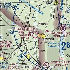
| Sectional chart |
|---|
|
| Airport distance calculator |
|---|
|
|
| Sunrise and sunset |
|---|
|
Times for 25-Apr-2024
| | Local
(UTC-4) | | Zulu
(UTC) |
|---|
| Morning civil twilight | | 05:43 | | 09:43 |
| Sunrise | | 06:14 | | 10:14 |
| Sunset | | 20:05 | | 00:05 |
| Evening civil twilight | | 20:35 | | 00:35 |
|
| Current date and time |
|---|
| Zulu (UTC) | 25-Apr-2024 13:30:34 |
|---|
| Local (UTC-4) | 25-Apr-2024 09:30:34 |
|---|
|
| METAR |
|---|
KDSV
15nm S | 251254Z AUTO 00000KT 10SM CLR 03/M01 A3040 RMK AO2 SLP309 T00331011
|
KGVQ
20nm NW | 251256Z AUTO 09009KT 10SM CLR 02/M05 A3040 RMK AO2 SLP302 T00171050 FZRANO
|
KROC
20nm N | 251254Z 14007KT 10SM CLR 03/M06 A3042 RMK AO2 SLP309 T00281056
|
KIUA
24nm E | 251315Z AUTO 05004KT 10SM CLR 03/M06 A3041 RMK AO2 T00311061
|
|
| TAF |
|---|
KROC
20nm N | 251130Z 2512/2612 07005KT P6SM SKC FM251600 02009KT P6SM SKC FM260000 04005KT P6SM SKC FM260200 VRB03KT P6SM SKC
|
|
| NOTAMs |
|---|
NOTAMs are issued by the DoD/FAA and will open in a separate window not controlled by AirNav.
|
|

