FAA INFORMATION EFFECTIVE 21 MARCH 2024
Location
| FAA Identifier: | DCM |
| Lat/Long: | 34-47-21.6000N 081-11-44.8000W
34-47.360000N 081-11.746667W
34.7893333,-81.1957778
(estimated) |
| Elevation: | 656.6 ft. / 200.1 m (surveyed) |
| Variation: | 06W (2000) |
| From city: | 5 miles N of CHESTER, SC |
| Time zone: | UTC -4 (UTC -5 during Standard Time) |
| Zip code: | 29706 |
Airport Operations
| Airport use: | Open to the public |
| Activation date: | 12/1943 |
| Control tower: | no |
| ARTCC: | ATLANTA CENTER |
| FSS: | ANDERSON FLIGHT SERVICE STATION |
| NOTAMs facility: | AND (NOTAM-D service available) |
| Attendance: | MON-SAT 0900-1800, ALL SUN 1300-1800 |
| Wind indicator: | lighted |
| Segmented circle: | yes |
| Lights: | ACTVT PAPI RWY 17 & 35; MIRL RWY 17/35 - CTAF. |
| Beacon: | white-green (lighted land airport)
Operates sunset to sunrise. |
Airport Communications
| CTAF/UNICOM: | 122.7 |
| WX AWOS-3: | 120.975 (803-385-2011) |
| CHARLOTTE APPROACH: | 120.05 |
| CHARLOTTE DEPARTURE: | 120.05 |
| JOOLS STAR: | 135.6 |
| RASLN STAR: | 126.15 |
| WX ASOS at UZA (14 nm NE): | 120.775 (803-981-9388) |
| WX AWOS-3 at LKR (17 nm E): | 120.825 (803-286-6444) |
Nearby radio navigation aids
| VOR radial/distance | | VOR name | | Freq | | Var |
|---|
| CLTr212/26.9 | | CHARLOTTE VOR/DME | | 115.00 | | 05W |
| SPAr114/38.8 | | SPARTANBURG VORTAC | | 115.70 | | 02W |
| NDB name | | Hdg/Dist | | Freq | | Var | | ID |
|---|
| CHESTER | | at field | | 220 | | 06W | | DCM | -.. -.-. -- |
| RALLY | | 228/8.3 | | 227 | | 05W | | UZ | ..- --.. |
| UNION COUNTY | | 080/22.9 | | 326 | | 06W | | UOT | ..- --- - |
| STONIA | | 190/24.2 | | 260 | | 06W | | GHJ | --. .... .--- |
| FIRST RIVER | | 151/34.1 | | 417 | | 06W | | SLP | ... .-.. .--. |
| ENOREE | | 044/36.0 | | 278 | | 07W | | EOE | . --- . |
Airport Services
| Fuel available: | 100LL JET-A
100LL:FOR FUEL OR ANY SVC AFT HRS CALL 803-385-6664. |
| Parking: | hangars and tiedowns |
| Airframe service: | NONE |
| Powerplant service: | NONE |
| Bottled oxygen: | NONE |
| Bulk oxygen: | NONE |
Runway Information
Runway 17/35
| Dimensions: | 5000 x 100 ft. / 1524 x 30 m |
| Surface: | asphalt, in fair condition |
| Weight bearing capacity: | | Single wheel: | 30.0 | | Double wheel: | 44.0 |
|
| Runway edge lights: | medium intensity |
| RUNWAY 17 | | RUNWAY 35 |
| Latitude: | 34-47.817898N | | 34-47.011558N |
| Longitude: | 081-12.023747W | | 081-11.816662W |
| Elevation: | 656.6 ft. | | 636.1 ft. |
| Traffic pattern: | right | | left |
| Runway heading: | 174 magnetic, 168 true | | 354 magnetic, 348 true |
| Markings: | nonprecision, in fair condition | | nonprecision, in fair condition |
| Visual slope indicator: | 2-light PAPI on left (3.00 degrees glide path) | | 2-light PAPI on left (3.00 degrees glide path) |
| Touchdown point: | yes, no lights | | yes, no lights |
| Obstructions: | 36 ft. tree, 779 ft. from runway, 140 ft. right of centerline, 16:1 slope to clear | | 38 ft. tree, 1426 ft. from runway, 180 ft. left of centerline, 32:1 slope to clear |
Runway 5/23
| Dimensions: | 4998 x 100 ft. / 1523 x 30 m |
| Surface: | asphalt, in poor condition
RWY 05/23 PCI RATING 40 VERY POOR. |
| Weight bearing capacity: | | Single wheel: | 4.0 | | Double wheel: | 12.0 |
|
| RUNWAY 5 | | RUNWAY 23 |
| Latitude: | 34-47.064740N | | 34-47.542292N |
| Longitude: | 081-11.979337W | | 081-11.165592W |
| Elevation: | 641.7 ft. | | 620.3 ft. |
| Traffic pattern: | right | | left |
| Runway heading: | 061 magnetic, 055 true | | 241 magnetic, 235 true |
| Displaced threshold: | 949 ft. | | no |
| Markings: | basic, in good condition | | basic, in good condition |
| Touchdown point: | yes, no lights | | yes, no lights |
| Obstructions: | 76 ft. tree, 1433 ft. from runway, 223 ft. left of centerline, 16:1 slope to clear | | 22 ft. tree, 310 ft. from runway, 86 ft. right of centerline, 5:1 slope to clear |
Airport Ownership and Management from official FAA records
| Ownership: | Publicly-owned |
| Owner: | COUNTY OF CHESTER
P.O. BOX 594
CHESTER, SC 29706
Phone (803) 385-3154 |
| Manager: | KEITH ROACH
1854-A, PIPER DR.
CHESTER, SC 29706
Phone 803-385-6664
ARPT CAN BE ACESD BY PEDESTRIAN GATE NEXT TO TRML BLDG AFT HRS BY FIRST FOUR NRS OF AWOS FREQ IN COMBINATION LOCK BOX. |
Airport Operational Statistics
| Aircraft based on the field: | | 29 | | Single engine airplanes: | | 27 | | Multi engine airplanes: | | 2 |
| |  | |
| Aircraft operations: avg 23/day * | | 71% | local general aviation | | 29% | transient general aviation | | * for 12-month period ending 23 June 2022 | |
Additional Remarks
| - | FOR CD CTC CHARLOTTE APCH AT 704-359-0241. |
Instrument Procedures
NOTE: All procedures below are presented as PDF files. If you need a reader for these files, you should download the free Adobe Reader.NOT FOR NAVIGATION. Please procure official charts for flight.
FAA instrument procedures published for use from 21 March 2024 at 0901Z to 18 April 2024 at 0900z.
STARs - Standard Terminal Arrivals |
|---|
| JOOLS ONE (RNAV) | |
download (273KB) |
| LIINN THREE | |
2 pages:
[1] [2] (312KB) |
| MAJIC FOUR | |
download (262KB) |
| RASLN THREE | |
download (197KB) |
IAPs - Instrument Approach Procedures |
|---|
| RNAV (GPS) RWY 17 | |
download (268KB) |
| RNAV (GPS) RWY 35 | |
download (268KB) |
| NDB RWY 35 | |
download (206KB) |
| NOTE: Special Alternate Minimums apply | |
download (162KB) |
| NOTE: Special Take-Off Minimums/Departure Procedures apply | |
download (141KB) |
Other nearby airports with instrument procedures:
KUZA - Rock Hill (York County) Airport-Bryant Field (14 nm NE)
KLKR - Lancaster County Airport-Mc Whirter Field (17 nm E)
N52 - JAARS-Townsend Airport (23 nm E)
35A - Union County Airport, Troy Shelton Field (23 nm W)
KAKH - Gastonia Municipal Airport (25 nm N)
|
|

Road maps at:
MapQuest
Bing
Google
| Aerial photo |
|---|
WARNING: Photo may not be current or correct

Do you have a better or more recent aerial photo of Chester Catawba Regional Airport that you would like to share? If so, please send us your photo.
|
| Sectional chart |
|---|
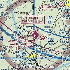
|
| Airport distance calculator |
|---|
|
|
| Sunrise and sunset |
|---|
|
Times for 16-Apr-2024
| | Local
(UTC-4) | | Zulu
(UTC) |
|---|
| Morning civil twilight | | 06:25 | | 10:25 |
| Sunrise | | 06:52 | | 10:52 |
| Sunset | | 19:57 | | 23:57 |
| Evening civil twilight | | 20:23 | | 00:23 |
|
| Current date and time |
|---|
| Zulu (UTC) | 16-Apr-2024 12:56:06 |
|---|
| Local (UTC-4) | 16-Apr-2024 08:56:06 |
|---|
|
| METAR |
|---|
| KDCM | 161235Z AUTO 00000KT 10SM CLR 17/11 A3012 RMK AO2 LTG DSNT NW
|
KUZA
14nm NE | 161154Z AUTO 00000KT 8SM CLR 16/13 A3010 RMK AO2 SLP184 T01560133 10206 20128 53022
|
KLKR
17nm E | 161235Z AUTO 00000KT 10SM CLR 17/13 A3011 RMK AO2
|
|
| TAF |
|---|
KCLT
28nm NE | 161120Z 1612/1718 07005KT P6SM BKN250 FM161800 20007KT P6SM SCT050 BKN250 FM170100 19005KT P6SM BKN250
|
|
| NOTAMs |
|---|
NOTAMs are issued by the DoD/FAA and will open in a separate window not controlled by AirNav.
|
|


