FAA INFORMATION EFFECTIVE 18 APRIL 2024
Location
| FAA Identifier: | HUF |
| Lat/Long: | 39-27-02.2750N 087-18-25.1640W
39-27.037917N 087-18.419400W
39.4506319,-87.3069900
(estimated) |
| Elevation: | 589.2 ft. / 179.6 m (surveyed) |
| Variation: | 02W (2000) |
| From city: | 5 miles E of TERRE HAUTE, IN |
| Time zone: | UTC -4 (UTC -5 during Standard Time) |
| Zip code: | 47803 |
Airport Operations
| Airport use: | Open to the public |
| Activation date: | 12/1944 |
| Control tower: | yes |
| ARTCC: | INDIANAPOLIS CENTER |
| FSS: | TERRE HAUTE FLIGHT SERVICE STATION |
| NOTAMs facility: | HUF (NOTAM-D service available) |
| Attendance: | CONTINUOUS |
| Wind indicator: | lighted |
| Segmented circle: | no |
| Beacon: | white-green (lighted land airport)
Operates sunset to sunrise. |
| Landing fee: | yes, LNDG FEE FOR CIVILIAN ACFT OVER 12,500 LBS. |
| Fire and rescue: | ARFF index A |
| Airline operations: | CLSD TO SKED ACR OPS GTR THAN 9 PSGR SEATS. UNSKED ACR OPS GTR THAN 30 PSGR SEATS RQR PPR - CTC 812-877-2524 OR 812-877-2252. INDEX B ARFF CAPABILITY AVBL ON REQ. |
| International operations: | US CUSTOMS USER FEE ARPT. |
Airport Communications
| UNICOM: | 122.95 |
| ATIS: | 127.5 269.375 |
| WX ASOS: | 127.5 (812-877-7010) |
| HULMAN GROUND: | 121.6 348.6 |
| HULMAN TOWER: | 134.725 322.475 |
| HULMAN APPROACH: | 125.45 339.8 119.8 263.125 |
| HULMAN DEPARTURE: | 125.45 339.8 119.8 263.125 |
| EMERG: | 243.0 |
Nearby radio navigation aids
| VOR radial/distance | | VOR name | | Freq | | Var |
|---|
| TTHr227/3.5 | | TERRE HAUTE VORTAC | | 115.30 | | 02E |
| OOMr302/37.1 | | HOOSIER VORTAC | | 110.20 | | 02W |
| NDB name | | Hdg/Dist | | Freq | | Var | | ID |
|---|
| YINNO | | 050/5.6 | | 245 | | 02W | | HU | .... ..- |
| PALESTINE | | 034/30.5 | | 391 | | 03W | | PLX | .--. .-.. -..- |
| CRAWFORDSVILLE | | 214/36.6 | | 388 | | 04W | | CFJ | -.-. ..-. .--- |
Airport Services
| Fuel available: | 100LL JET-A |
| Parking: | hangars and tiedowns |
| Airframe service: | MAJOR |
| Powerplant service: | MAJOR |
| Bottled oxygen: | NONE |
Runway Information
Runway 5/23
| Dimensions: | 9021 x 150 ft. / 2750 x 46 m
1000 FT PAVED BLAST PAD SW END & 1325 FT PAVED BLAST PAD NE END; RY 32 400 FT BY 150 FT BLAST PAD; NOT AVBL FOR ASDA. |
| Surface: | asphalt/grooved, in fair condition |
| Weight bearing capacity: | | PCN 49 /R/C/W/U | | Single wheel: | 75.0 | | Double wheel: | 200.0 | | Double tandem: | 300.0 | | Dual double tandem: | 600.0 |
|
| Runway edge lights: | high intensity |
| RUNWAY 5 | | RUNWAY 23 |
| Latitude: | 39-26.431197N | | 39-27.440628N |
| Longitude: | 087-19.389478W | | 087-17.983137W |
| Elevation: | 572.3 ft. | | 582.2 ft. |
| Traffic pattern: | left | | left |
| Runway heading: | 049 magnetic, 047 true | | 229 magnetic, 227 true |
| Declared distances: | TORA:9020 TODA:9020 ASDA:9020 LDA:9020 | | TORA:9020 TODA:9020 ASDA:9020 LDA:9020 |
| Markings: | precision, in fair condition | | precision, in fair condition |
| Visual slope indicator: | 4-light PAPI on left (3.00 degrees glide path) | | 4-light PAPI on left (3.00 degrees glide path) |
| RVR equipment: | touchdown | | rollout |
| Approach lights: | MALSR: 1,400 foot medium intensity approach lighting system with runway alignment indicator lights | | |
| Runway end identifier lights: | no | | yes |
| Touchdown point: | yes, no lights | | yes, no lights |
| Instrument approach: | ILS | | |
| Obstructions: | 54 ft. stack, 2841 ft. from runway, 412 ft. left of centerline, 48:1 slope to clear | | 71 ft. tree, 2297 ft. from runway, 535 ft. right of centerline, 29:1 slope to clear |
Runway 14/32
| Dimensions: | 7200 x 150 ft. / 2195 x 46 m |
| Surface: | asphalt/concrete/grooved, in fair condition |
| Weight bearing capacity: | | PCN 42 /F/C/X/U | | Single wheel: | 75.0 | | Double wheel: | 200.0 | | Double tandem: | 300.0 |
|
| Runway edge lights: | high intensity |
| RUNWAY 14 | | RUNWAY 32 |
| Latitude: | 39-27.584323N | | 39-26.746940N |
| Longitude: | 087-18.626658W | | 087-17.543305W |
| Elevation: | 568.0 ft. | | 589.1 ft. |
| Traffic pattern: | left | | left |
| Runway heading: | 137 magnetic, 135 true | | 317 magnetic, 315 true |
| Declared distances: | TORA:7200 TODA:7200 ASDA:7200 LDA:7200 | | TORA:7200 TODA:7200 ASDA:7200 LDA:7200 |
| Markings: | nonprecision, in good condition | | nonprecision, in good condition |
| Visual slope indicator: | 4-light PAPI on left (2.75 degrees glide path) | | 4-light PAPI on left (3.00 degrees glide path) |
| Runway end identifier lights: | yes | | yes |
| Touchdown point: | yes, no lights | | yes, no lights |
| Obstructions: | 105 ft. tree, 2597 ft. from runway, 341 ft. left of centerline, 22:1 slope to clear | | none |
Airport Ownership and Management from official FAA records
| Ownership: | Publicly-owned |
| Owner: | TERRE HAUTE RGNL ARPT AUTH
581 S. AIRPORT ST.
TERRE HAUTE, IN 47803
Phone 812-877-2524 |
| Manager: | JEFF HAUSER
581 S. AIRPORT ST.
TERRE HAUTE, IN 47803
Phone 812-877-2524 |
Airport Operational Statistics
| Aircraft based on the field: | | 79 | | Single engine airplanes: | | 70 | | Multi engine airplanes: | | 7 | | Jet airplanes: | | 1 | | Gliders airplanes: | | 1 |
| |  | |
| Aircraft operations: avg 199/day * | | 56% | local general aviation | | 39% | transient general aviation | | 4% | air taxi | | <1% | military | | <1% | commercial | | * for 12-month period ending 31 December 2022 | |
Additional Remarks
| - | BIRDS ON & INVOF ARPT. |
| - | ACFT SVCS AVBL 2200 & 0600 SUBJECT TO AFTER-HRS CALLOUT FEE. |
Instrument Procedures
NOTE: All procedures below are presented as PDF files. If you need a reader for these files, you should download the free Adobe Reader.NOT FOR NAVIGATION. Please procure official charts for flight.
FAA instrument procedures published for use from 18 April 2024 at 0901Z to 16 May 2024 at 0900Z.
IAPs - Instrument Approach Procedures |
|---|
| ILS OR LOC RWY 05 | |
download (276KB) |
| RNAV (GPS) RWY 05 | |
download (278KB) |
| RNAV (GPS) RWY 14 | |
download (234KB) |
| RNAV (GPS) RWY 23 | |
download (266KB) |
| RNAV (GPS) RWY 32 | |
download (232KB) |
| VOR RWY 05 | |
download (222KB) |
| Radar Approach Procedures available | |
download (212KB) |
| NOTE: Special Alternate Minimums apply | |
download (168KB) |
| NOTE: Special Take-Off Minimums/Departure Procedures apply | |
download (272KB) |
Other nearby airports with instrument procedures:
3I3 - Sky King Airport (7 nm NW)
0I2 - Brazil Clay County Airport (10 nm E)
KSIV - Sullivan County Airport (21 nm S)
KPRG - Edgar County Airport (23 nm NW)
KGPC - Putnam County Regional Airport (25 nm NE)
|
|

Road maps at:
MapQuest
Bing
Google
| Aerial photo |
|---|
WARNING: Photo may not be current or correct
 Photo by David Newcomer
Taken in December 2017
looking north from 5,500' MSL.
Photo by David Newcomer
Taken in December 2017
looking north from 5,500' MSL.
Do you have a better or more recent aerial photo of Terre Haute Regional Airport that you would like to share? If so, please send us your photo.
|
| Sectional chart |
|---|
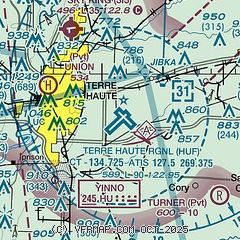
|
CAUTION: Diagram may not be current
 Download PDF
of official airport diagram from the FAA
| Airport distance calculator |
|---|
|
|
| Sunrise and sunset |
|---|
|
Times for 18-Apr-2024
| | Local
(UTC-4) | | Zulu
(UTC) |
|---|
| Morning civil twilight | | 06:39 | | 10:39 |
| Sunrise | | 07:07 | | 11:07 |
| Sunset | | 20:30 | | 00:30 |
| Evening civil twilight | | 20:58 | | 00:58 |
|
| Current date and time |
|---|
| Zulu (UTC) | 19-Apr-2024 02:37:15 |
|---|
| Local (UTC-4) | 18-Apr-2024 22:37:15 |
|---|
|
| METAR |
|---|
| KHUF | 190220Z 25014G32KT 2SM R05/6000VP6000FT +TSRA BR BKN037 BKN055 OVC075 19/17 A2984 RMK AO2 PK WND 23032/0212 LTG DSNT ALQDS P0020 T01890172
|
|
| TAF |
|---|
| KHUF | 181743Z 1818/1918 16007KT P6SM SCT240 FM190000 23012G20KT P6SM -SHRA BKN060 TEMPO 1901/1903 4SM TSRA BR OVC025CB FM190500 29011KT P6SM -SHRA VCTS OVC011CB FM190600 32013KT P6SM VCTS BKN007CB FM190800 34014G23KT P6SM BKN011 FM191300 34012KT P6SM SCT060
|
|
| NOTAMs |
|---|
NOTAMs are issued by the DoD/FAA and will open in a separate window not controlled by AirNav.
|
|


