FAA INFORMATION EFFECTIVE 18 APRIL 2024
Location
| FAA Identifier: | JQF |
| Lat/Long: | 35-23-15.9730N 080-42-32.8770W
35-23.266217N 080-42.547950W
35.3877703,-80.7091325
(estimated) |
| Elevation: | 704.2 ft. / 214.6 m (surveyed) |
| Variation: | 06W (1995) |
| From city: | 7 miles W of CONCORD, NC |
| Time zone: | UTC -4 (UTC -5 during Standard Time) |
| Zip code: | 28075 |
Airport Operations
| Airport use: | Open to the public |
| Activation date: | 11/1993 |
| Control tower: | yes |
| ARTCC: | ATLANTA CENTER |
| FSS: | RALEIGH FLIGHT SERVICE STATION |
| NOTAMs facility: | JQF (NOTAM-D service available) |
| Attendance: | CONTINUOUS |
| Wind indicator: | lighted |
| Segmented circle: | yes |
| Lights: | WHEN ATCT CLSD; TDZL RWY 20; HIRL RWY 02/20 & REIL RWY 02 PRESET LOW INTST. ACTVT MALSR RWY 20; REIL RWY 02; TDZL RWY 20; HIRL RWY 02/20 - CTAF. |
| Beacon: | white-green (lighted land airport)
Operates sunset to sunrise. |
| Fire and rescue: | ARFF index C |
Airport Communications
| CTAF: | 134.65 |
| UNICOM: | 122.95 |
| ATIS: | 133.675 |
| WX AWOS-3: | 133.675 (704-785-2145) |
| CONCORD GROUND: | 121.85 [0700-2300] |
| CONCORD TOWER: | 134.65 [0700-2300] |
| CHARLOTTE APPROACH: | 128.325 |
| CHARLOTTE DEPARTURE: | 128.325 |
| CLEARANCE DELIVERY: | 127.25 118.55 |
| BARMY DP: | 128.325 |
| BEAVY DP: | 128.325 |
| BOBZY DP: | 128.325 |
| ESTRR DP: | 128.325 |
| ICONS DP: | 128.325 |
| JOJJO DP: | 128.325 |
| JOOLS STAR: | 135.6 |
| KABEE STAR: | 126.15 |
| KERMIT DP: | 128.325 |
| KILNS DP: | 128.325 |
| KNIGHTS DP: | 128.325 |
| KRITR DP: | 128.325 |
| KWEEN DP: | 128.325 |
| LILLS DP: | 128.325 |
| NASCR STAR: | 128.325 |
| WEAZL DP: | 128.325 |
| WX ASOS at CLT (16 nm SW): | PHONE 704-790-5484 |
| WX AWOS-3 at RUQ (18 nm NE): | 118.175 (704-637-6197) |
Nearby radio navigation aids
| VOR radial/distance | | VOR name | | Freq | | Var |
|---|
| CLTr050/16.8 | | CHARLOTTE VOR/DME | | 115.00 | | 05W |
| BZMr144/38.8 | | BARRETTS MOUNTAIN VOR/DME | | 113.75 | | 06W |
| NDB name | | Hdg/Dist | | Freq | | Var | | ID |
|---|
| STONIA | | 068/24.9 | | 260 | | 06W | | GHJ | --. .... .--- |
Airport Services
| Fuel available: | 100LL JET-A JET-A1+ |
| Parking: | hangars and tiedowns |
| Airframe service: | MAJOR |
| Powerplant service: | MAJOR |
| Bottled oxygen: | HIGH |
Runway Information
Runway 2/20
| Dimensions: | 7402 x 100 ft. / 2256 x 30 m |
| Surface: | asphalt/grooved, in good condition
GROOVED FULL LENGTH ASPHALT. |
| Weight bearing capacity: | | PCN 39 /F/C/X/T | | Double wheel: | 129.0 |
|
| Runway edge lights: | high intensity |
| RUNWAY 2 | | RUNWAY 20 |
| Latitude: | 35-22.666350N | | 35-23.866067N |
| Longitude: | 080-42.683177W | | 080-42.412698W |
| Elevation: | 639.4 ft. | | 704.2 ft. |
| Traffic pattern: | left | | left |
| Runway heading: | 016 magnetic, 010 true | | 196 magnetic, 190 true |
| Displaced threshold: | no | | 650 ft. |
| Declared distances: | TORA:7400 TODA:7400 ASDA:7400 LDA:7400 | | TORA:7400 TODA:7400 ASDA:7000 LDA:6350 |
| Markings: | precision, in good condition | | precision, in good condition |
| Visual slope indicator: | 4-light PAPI on left (3.50 degrees glide path) | | 4-light PAPI on left (3.00 degrees glide path) |
| Approach lights: | | | MALSR: 1,400 foot medium intensity approach lighting system with runway alignment indicator lights |
| Runway end identifier lights: | yes | | |
| Touchdown point: | yes, no lights | | yes, lighted |
| Instrument approach: | | | ILS/DME |
| Obstructions: | 13 ft. trees, 281 ft. from runway, 248 ft. left of centerline, 6:1 slope to clear | | 127 ft. trees, 3200 ft. from runway, 500 ft. right of centerline, 23:1 slope to clear |
Airport Ownership and Management from official FAA records
| Ownership: | Publicly-owned |
| Owner: | CITY OF CONCORD
9000 AVIATION BLVD
CONCORD, NC 28027
Phone 704-920-5900 |
| Manager: | DANNY JACOBS
9000 AVIATION BLVD
CONCORD, NC 28027
Phone (704) 920-5941 |
Airport Operational Statistics
| Aircraft based on the field: | | 245 | | Single engine airplanes: | | 176 | | Multi engine airplanes: | | 26 | | Jet airplanes: | | 35 | | Helicopters: | | 8 |
| |  | |
| Aircraft operations: avg 239/day * | | 58% | transient general aviation | | 22% | local general aviation | | 17% | air taxi | | 3% | commercial | | <1% | military | | * for 12-month period ending 31 July 2023 | |
Additional Remarks
| - | FOR CD WHEN ATCT IS CLSD CTC CLT APCH AT 704-359-0241. |
Instrument Procedures
NOTE: All procedures below are presented as PDF files. If you need a reader for these files, you should download the free Adobe Reader.NOT FOR NAVIGATION. Please procure official charts for flight.
FAA instrument procedures published for use from 18 April 2024 at 0901Z to 16 May 2024 at 0900Z.
STARs - Standard Terminal Arrivals |
|---|
| JOOLS ONE (RNAV) | |
download (274KB) |
| KABEE THREE (RNAV) | |
download (153KB) |
| NASCR FOUR **CHANGED** | |
download (213KB) |
IAPs - Instrument Approach Procedures |
|---|
| ILS OR LOC RWY 20 | |
download (319KB) |
| RNAV (GPS) RWY 02 | |
download (261KB) |
| RNAV (GPS) RWY 20 | |
download (247KB) |
| NOTE: Special Alternate Minimums apply | |
download (48KB) |
Departure Procedures |
|---|
| BARMY FIVE (RNAV) **NEW** | |
download (237KB) |
| BEAVY SIX (RNAV) **NEW** | |
download (221KB) |
| BOBZY FIVE (RNAV) **NEW** | |
download (240KB) |
| ESTRR FIVE (RNAV) **NEW** | |
download (208KB) |
| ICONS FIVE (RNAV) **NEW** | |
download (209KB) |
| JOJJO FIVE (RNAV) **NEW** | |
download (261KB) |
| KERMIT FOUR **NEW** | |
2 pages:
[1] [2] (403KB) |
| KILNS FIVE (RNAV) **NEW** | |
download (212KB) |
| KNIGHTS THREE **NEW** | |
2 pages:
[1] [2] (391KB) |
| KRITR SIX (RNAV) **NEW** | |
download (210KB) |
| KWEEN FIVE (RNAV) **NEW** | |
download (213KB) |
| LILLS THREE (RNAV) **NEW** | |
download (190KB) |
| WEAZL FIVE (RNAV) **NEW** | |
download (189KB) |
| NOTE: Special Take-Off Minimums/Departure Procedures apply | |
download (141KB) |
Other nearby airports with instrument procedures:
KCLT - Charlotte/Douglas International Airport (16 nm SW)
14A - Lake Norman Airpark (16 nm NW)
KRUQ - Mid-Carolina Regional Airport (18 nm NE)
KEQY - Charlotte-Monroe Executive Airport (23 nm S)
KIPJ - Lincolnton-Lincoln County Regional Airport (23 nm W)
|
|

Road maps at:
MapQuest
Bing
Google
| Aerial photo |
|---|
WARNING: Photo may not be current or correct
 Photo taken 26-Dec-2017
looking southwest.
Photo taken 26-Dec-2017
looking southwest.
Do you have a better or more recent aerial photo of Concord-Padgett Regional Airport that you would like to share? If so, please send us your photo.
|
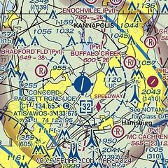
| Sectional chart |
|---|
|
CAUTION: Diagram may not be current
 Download PDF
of official airport diagram from the FAA
| Airport distance calculator |
|---|
|
|
| Sunrise and sunset |
|---|
|
Times for 19-Apr-2024
| | Local
(UTC-4) | | Zulu
(UTC) |
|---|
| Morning civil twilight | | 06:19 | | 10:19 |
| Sunrise | | 06:45 | | 10:45 |
| Sunset | | 19:59 | | 23:59 |
| Evening civil twilight | | 20:25 | | 00:25 |
|
| Current date and time |
|---|
| Zulu (UTC) | 19-Apr-2024 15:27:45 |
|---|
| Local (UTC-4) | 19-Apr-2024 11:27:45 |
|---|
|
| METAR |
|---|
| KJQF | 191350Z 00000KT 10SM CLR 24/13 A3004
|
KCLT
16nm SW | 191452Z 25010KT 10SM FEW110 SCT150 BKN250 27/16 A3001 RMK AO2 SLP166 T02670161 50002
|
KRUQ
18nm NE | 191455Z AUTO 00000KT 10SM CLR 22/13 A3002 RMK AO2 T02230129
|
|
| TAF |
|---|
KCLT
16nm SW | 191357Z 1914/2018 26006KT P6SM VCSH SCT050 BKN100 FM191600 21006KT P6SM FEW050 SCT100 BKN250 FM191800 24007KT P6SM SCT060 PROB30 1922/2002 4SM TSRA BR OVC025CB FM200200 30006KT P6SM FEW060 BKN250 FM200400 35006KT P6SM BKN100 FM201300 01007KT P6SM SCT024 BKN045
|
|
| NOTAMs |
|---|
NOTAMs are issued by the DoD/FAA and will open in a separate window not controlled by AirNav.
|
|


