FAA INFORMATION EFFECTIVE 18 APRIL 2024
Location
| FAA Identifier: | K59 |
| Lat/Long: | 39-34-13.8890N 095-10-49.1930W
39-34.231483N 095-10.819883W
39.5705247,-95.1803314
(estimated) |
| Elevation: | 1073 ft. / 327.1 m (surveyed) |
| Variation: | 02E (2020) |
| From city: | 2 miles W of ATCHISON, KS |
| Time zone: | UTC -5 (UTC -6 during Standard Time) |
| Zip code: | 66002 |
Airport Operations
| Airport use: | Open to the public |
| Activation date: | 06/1952 |
| Control tower: | no |
| ARTCC: | KANSAS CITY CENTER |
| FSS: | WICHITA FLIGHT SERVICE STATION |
| NOTAMs facility: | ICT (NOTAM-D service available) |
| Attendance: | 0900-1900 |
| Wind indicator: | lighted |
| Segmented circle: | no |
| Lights: | ACTVT LIRL RWY 16/34 - CTAF. |
| Beacon: | white-green (lighted land airport)
Operates sunset to sunrise. |
Airport Communications
| CTAF/UNICOM: | 122.8 |
| WX AWOS-3PT: | 123.675 (913-367-1449) |
| ST JOSEPH APPROACH: | 124.7 120.35 |
| ST JOSEPH DEPARTURE: | 124.7 120.35 |
| WX ASOS at STJ (17 nm NE): | 125.05 (816-233-0666) |
Nearby radio navigation aids
| VOR radial/distance | | VOR name | | Freq | | Var |
|---|
| STJr199/26.2 | | ST JOSEPH VORTAC | | 115.50 | | 08E |
| MCIr305/26.7 | | KANSAS CITY VORTAC | | 113.25 | | 05E |
| TOPr028/31.1 | | TOPEKA VORTAC | | 117.80 | | 05E |
| NDB name | | Hdg/Dist | | Freq | | Var | | ID |
|---|
| TARIO | | 239/14.1 | | 260 | | 04E | | ST | ... - |
| AMAZON | | 210/22.6 | | 233 | | 04E | | AZN | .- --.. -. |
Airport Services
| Fuel available: | 100LL JET-A+
A+:24 HR SELF SVC FUEL AVBL. |
| Parking: | hangars and tiedowns |
| Airframe service: | MAJOR |
| Powerplant service: | MAJOR |
| Bottled oxygen: | NONE |
| Bulk oxygen: | NONE |
Runway Information
Runway 16/34
| Dimensions: | 3000 x 48 ft. / 914 x 15 m |
| Surface: | asphalt, in fair condition |
| Weight bearing capacity: | | PCN 7 /F/C/Y/U | | Single wheel: | 17.0 |
|
| Runway edge lights: | low intensity
RWY 16/34 NSTD LIRL; RY END LGTS AT DEP END RY 16 ARE NOT SPLIT LENSES. SOME EDGE LGTS OTS INDEFLY. |
| Operational restrictions: | LN OF SIGHT OBSTD BTWN RWY ENDS. |
| RUNWAY 16 | | RUNWAY 34 |
| Latitude: | 39-34.477267N | | 39-33.986417N |
| Longitude: | 095-10.855717W | | 095-10.783150W |
| Elevation: | 1040.0 ft. | | 1072.0 ft. |
| Traffic pattern: | left | | left |
| Runway heading: | 171 magnetic, 173 true | | 351 magnetic, 353 true |
| Displaced threshold: | no | | 202 ft. |
| Markings: | basic, in good condition | | basic, in good condition |
| Touchdown point: | yes, no lights | | yes, no lights |
| Obstructions: | 60 ft. trees, 1173 ft. from runway, 279 ft. right of centerline, 16:1 slope to clear | | 15 ft. road, 287 ft. from runway, 5:1 slope to clear
OBSTN CLNC SLOPE TO DSPLD THLD 50:1. |
Airport Ownership and Management from official FAA records
| Ownership: | Publicly-owned |
| Owner: | CITY OF ATCHISON
515 KANSAS AVE
ATCHISON, KS 66002
Phone 913-367-5500 |
| Manager: | CLINTON MCNEMEE
515 KANSAS AVE
ATCHISON, KS 66002
Phone 913-426-0311
ALT PH NUMBER 913-568-3819. |
Airport Operational Statistics
| Aircraft based on the field: | | 24 | | Single engine airplanes: | | 21 | | Multi engine airplanes: | | 2 | | Gliders airplanes: | | 1 |
| |  | |
| Aircraft operations: avg 44/day * | | 68% | local general aviation | | 31% | transient general aviation | | <1% | military | | <1% | air taxi | | * for 12-month period ending 27 September 2022 | |
Additional Remarks
| - | GLIDER OPNS FM GRASS WEST SIDE OF RWY. |
| - | A HEAVY CROPDUSTING OPS. |
| - | FOR CD CTC KANSAS CITY APCH AT 816-329-2710. |
| - | CTN - ROAD AND TREES 15 - 55 FT AGL; 302 - 438 FT FM RWY 34 THLD; 0-225 FT L AND R. |
| - | (CONTACT TITLE) INTERIM CITY MGR BECKY BERGER, ALTN CLINTON MCNEMEE 913-367-5561. |
Instrument Procedures
NOTE: All procedures below are presented as PDF files. If you need a reader for these files, you should download the free Adobe Reader.NOT FOR NAVIGATION. Please procure official charts for flight.
FAA instrument procedures published for use from 18 April 2024 at 0901Z to 16 May 2024 at 0900Z.
IAPs - Instrument Approach Procedures |
|---|
| RNAV (GPS) RWY 16 | |
download (181KB) |
| NOTE: Special Take-Off Minimums/Departure Procedures apply | |
download (147KB) |
Other nearby airports with instrument procedures:
KFLV - Sherman Army Airfield (17 nm SE)
KSTJ - Rosecrans Memorial Airport (17 nm NE)
KMCI - Kansas City International Airport (27 nm SE)
KLWC - Lawrence Regional Airport (34 nm S)
KFNB - Brenner Field Airport (36 nm NW)
|
|

Road maps at:
MapQuest
Bing
Google
| Aerial photo |
|---|
WARNING: Photo may not be current or correct
 Taken in May 2005
during the EAA 967 flyin
Taken in May 2005
during the EAA 967 flyin
Do you have a better or more recent aerial photo of Amelia Earhart Airport that you would like to share? If so, please send us your photo.
|
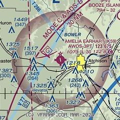
| Sectional chart |
|---|
|
| Airport distance calculator |
|---|
|
|
| Sunrise and sunset |
|---|
|
Times for 23-Apr-2024
| | Local
(UTC-5) | | Zulu
(UTC) |
|---|
| Morning civil twilight | | 06:03 | | 11:03 |
| Sunrise | | 06:32 | | 11:32 |
| Sunset | | 20:06 | | 01:06 |
| Evening civil twilight | | 20:35 | | 01:35 |
|
| Current date and time |
|---|
| Zulu (UTC) | 23-Apr-2024 11:27:20 |
|---|
| Local (UTC-5) | 23-Apr-2024 06:27:20 |
|---|
|
| METAR |
|---|
KSTJ
17nm NE | 231053Z AUTO 00000KT 10SM -RA OVC110 13/08 A2983 RMK AO2 LTG DSNT ALQDS RAB19 SLP097 P0001 T01280083
|
KMCI
26nm SE | 231053Z 19006KT 10SM FEW080 BKN100 13/06 A2984 RMK AO2 LTG DSNT NE AND E AND W SLP099 T01330061
|
KLWC
33nm S | 231052Z AUTO 00000KT 10SM CLR 13/06 A2985 RMK AO1 LTG DSNT N SLP103 T01280061 $
|
|
| TAF |
|---|
KSTJ
17nm NE | 230642Z 2307/2406 19011KT 6SM -TSRA SCT090 BKN100CB FM230800 20013KT P6SM VCSH SCT090 BKN100 TEMPO 2308/2310 5SM -TSRA BR OVC040CB FM231200 30010KT P6SM BKN050 OVC120 FM231500 33014G24KT P6SM SCT050 BKN200 FM240100 36010KT P6SM SCT250
|
|
| NOTAMs |
|---|
NOTAMs are issued by the DoD/FAA and will open in a separate window not controlled by AirNav.
|
|

