FAA INFORMATION EFFECTIVE 18 APRIL 2024
Location
| FAA Identifier: | OVE |
| Lat/Long: | 39-29-16.1000N 121-37-19.2000W
39-29.268333N 121-37.320000W
39.4878056,-121.6220000
(estimated) |
| Elevation: | 194.3 ft. / 59.2 m (surveyed) |
| Variation: | 16E (1990) |
| From city: | 3 miles SW of OROVILLE, CA |
| Time zone: | UTC -7 (UTC -8 during Standard Time) |
| Zip code: | 95965 |
Airport Operations
| Airport use: | Open to the public |
| Activation date: | 04/1940 |
| Control tower: | no |
| ARTCC: | OAKLAND CENTER |
| FSS: | RANCHO MURIETA FLIGHT SERVICE STATION |
| NOTAMs facility: | OVE (NOTAM-D service available) |
| Attendance: | MON-SAT 0800-1700 |
| Pattern altitude: | 994.3 ft. MSL |
| Wind indicator: | lighted |
| Segmented circle: | yes |
| Lights: | ACTVT REIL RWY 02 & 20; PAPI RWY 02, 13, 20 & 31; HIRL RWY 02/20 & RWY 13/31 - CTAF. |
| Beacon: | white-green (lighted land airport)
Operates sunset to sunrise. |
Airport Communications
| CTAF/UNICOM: | 122.8 |
| WX ASOS: | 121.425 (530-533-5792) |
| NORCAL APPROACH: | 125.4 |
| NORCAL DEPARTURE: | 125.4 |
Nearby radio navigation aids
| VOR radial/distance | | VOR name | | Freq | | Var |
|---|
| MYVr338/23.5 | | MARYSVILLE VOR/DME | | 110.80 | | 16E |
| ILAr019/31.3 | | WILLIAMS VORTAC | | 114.40 | | 18E |
Airport Services
| Fuel available: | 100LL JET-A |
| Parking: | tiedowns |
| Airframe service: | MAJOR |
| Powerplant service: | MINOR |
| Bottled oxygen: | NONE |
| Bulk oxygen: | NONE |
Runway Information
Runway 2/20
| Dimensions: | 6020 x 100 ft. / 1835 x 30 m |
| Surface: | asphalt, in good condition |
| Weight bearing capacity: | | Single wheel: | 47.0 | | Double wheel: | 90.0 |
|
| Runway edge lights: | high intensity |
| RUNWAY 2 | | RUNWAY 20 |
| Latitude: | 39-28.730940N | | 39-29.562790N |
| Longitude: | 121-37.908518W | | 121-37.211988W |
| Elevation: | 181.5 ft. | | 184.6 ft. |
| Traffic pattern: | left | | left |
| Runway heading: | 017 magnetic, 033 true | | 197 magnetic, 213 true |
| Markings: | nonprecision, in good condition | | nonprecision, in good condition |
| Visual slope indicator: | 2-light PAPI on left (3.00 degrees glide path) | | 2-light PAPI on left (3.00 degrees glide path)
DOES NOT PRVD OBSTN CLNC BYD 3 NM. |
| Runway end identifier lights: | yes | | yes |
| Touchdown point: | yes, no lights | | yes, no lights |
Runway 13/31
| Dimensions: | 3540 x 100 ft. / 1079 x 30 m |
| Surface: | asphalt, in good condition |
| Weight bearing capacity: | | Single wheel: | 19.0 | | Double wheel: | 31.0 |
|
| Runway edge lights: | high intensity |
| RUNWAY 13 | | RUNWAY 31 |
| Latitude: | 39-29.712300N | | 39-29.242022N |
| Longitude: | 121-37.131727W | | 121-36.686962W |
| Elevation: | 192.8 ft. | | 176.9 ft. |
| Traffic pattern: | left | | left |
| Runway heading: | 128 magnetic, 144 true | | 308 magnetic, 324 true |
| Markings: | basic, in good condition | | basic, in good condition |
| Visual slope indicator: | 2-light PAPI on left (3.00 degrees glide path) | | 2-light PAPI on left (3.00 degrees glide path) |
| Runway end identifier lights: | no | | no |
| Touchdown point: | yes, no lights | | yes, no lights |
| Obstructions: | none | | 20 ft. trees, 600 ft. from runway, 200 ft. left of centerline, 20:1 slope to clear |
Airport Ownership and Management from official FAA records
| Ownership: | Publicly-owned |
| Owner: | CITY OF OROVILLE
1735 MONTGOMERY ST
OROVILLE, CA 95965
Phone 530-538-2405 |
| Manager: | CODY NISSEN
1735 MONTGOMERY ST.
OROVILLE, CA 95965
Phone 530-538-2490 |
Airport Operational Statistics
| Aircraft based on the field: | | 45 | | Single engine airplanes: | | 41 | | Helicopters: | | 1 | | Gliders airplanes: | | 1 | | Ultralights: | | 2 |
| |  | |
| Aircraft operations: avg 99/day * | | 56% | transient general aviation | | 40% | local general aviation | | 4% | air taxi | | * for 12-month period ending 31 December 2022 | |
Additional Remarks
| - | TWY FROM RY 02/20 TO GOLF COURSE/RESTAURANT TIEDOWNS 20 FT WIDE WITH NO SHOULDERS. |
| - | FIREFIGHTING ACFT INVOF ARPT MAY-OCT. |
| - | FOR ARPT INFO MON-FRI CTC (530) 538-2420. |
| - | FOR CD CTC NORCAL APCH AT 916-361-6874. |
Instrument Procedures
NOTE: All procedures below are presented as PDF files. If you need a reader for these files, you should download the free Adobe Reader.NOT FOR NAVIGATION. Please procure official charts for flight.
FAA instrument procedures published for use from 18 April 2024 at 0901Z to 16 May 2024 at 0900Z.
IAPs - Instrument Approach Procedures |
|---|
| RNAV (GPS) RWY 02 | |
download (232KB) |
| VOR-A | |
download (174KB) |
| NOTE: Special Take-Off Minimums/Departure Procedures apply | |
download (227KB) |
Other nearby airports with instrument procedures:
KCIC - Chico Regional Airport (21 nm NW)
KBAB - Beale Air Force Base (23 nm S)
KMYV - Yuba County Airport (24 nm S)
O08 - Colusa County Airport (25 nm SW)
KWLW - Willows/Glenn County Airport (28 nm W)
|
|

Road maps at:
MapQuest
Bing
Google
| Aerial photo |
|---|
WARNING: Photo may not be current or correct

Do you have a better or more recent aerial photo of Oroville Municipal Airport that you would like to share? If so, please send us your photo.
|
| Sectional chart |
|---|
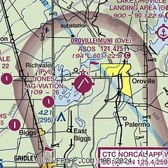
|
CAUTION: Diagram may not be current

| Airport distance calculator |
|---|
|
|
| Sunrise and sunset |
|---|
|
Times for 20-Apr-2024
| | Local
(UTC-7) | | Zulu
(UTC) |
|---|
| Morning civil twilight | | 05:53 | | 12:53 |
| Sunrise | | 06:22 | | 13:22 |
| Sunset | | 19:49 | | 02:49 |
| Evening civil twilight | | 20:17 | | 03:17 |
|
| Current date and time |
|---|
| Zulu (UTC) | 20-Apr-2024 14:17:39 |
|---|
| Local (UTC-7) | 20-Apr-2024 07:17:39 |
|---|
|
| METAR |
|---|
| KOVE | 201353Z AUTO 08004KT 10SM CLR 15/12 A3001 RMK AO2 SLP164 T01500117
|
|
| TAF |
|---|
KBAB
23nm S | 200630Z 2006/2111 14006KT 9999 FEW240 QNH2984INS BECMG 2017/2018 19006KT 9999 FEW200 QNH2996INS WND VRB06KT AFT 2102 TX28/2023Z TN12/2013Z LAST NO AMDS AFT 2006 NEXT 2212
|
|
| NOTAMs |
|---|
NOTAMs are issued by the DoD/FAA and will open in a separate window not controlled by AirNav.
|
|


