FAA INFORMATION EFFECTIVE 18 APRIL 2024
Location
| FAA Identifier: | PWA |
| Lat/Long: | 35-32-02.9900N 097-38-49.3900W
35-32.049833N 097-38.823167W
35.5341639,-97.6470528
(estimated) |
| Elevation: | 1299.6 ft. / 396.1 m (surveyed) |
| Variation: | 05E (2010) |
| From city: | 7 miles NW of OKLAHOMA CITY, OK |
| Time zone: | UTC -5 (UTC -6 during Standard Time) |
| Zip code: | 73008 |
Airport Operations
| Airport use: | Open to the public |
| Activation date: | 02/1943 |
| Control tower: | yes |
| ARTCC: | FORT WORTH CENTER |
| FSS: | MC ALESTER FLIGHT SERVICE STATION |
| NOTAMs facility: | PWA (NOTAM-D service available) |
| Attendance: | CONTINUOUS |
| Pattern altitude: | TPA RWY 17R/35L 600 FT AGL, ALL OTHER RWYS 1000 FT AGL. |
| Wind indicator: | lighted |
| Segmented circle: | yes |
| Lights: | DUSK-DAWN; WHEN ATCT CLSD ACTVT MALSR RWY 17L & 35R; HIRL RWY 17L/35R - CTAF. |
| Beacon: | white-green (lighted land airport)
Operates sunset to sunrise. |
Airport Communications
| CTAF: | 126.9 |
| UNICOM: | 122.95 |
| ATIS: | 128.725 |
| WX ASOS: | PHONE 405-798-2013 |
| WILEY POST GROUND: | 121.7 [0700-2200] |
| WILEY POST TOWER: | 126.9 306.9 [0700-2200] |
| OKE CITY APPROACH: | 120.45 ;081-170 124.2 ;001-080 124.6 ;171-360 |
| OKE CITY DEPARTURE: | 120.45 ;081-170 124.2 ;001-080 124.6 ;171-360 |
| BASTS RNAV STAR: | 124.6 |
| CCASH RNAV STAR: | 124.6 |
| DAWKS RNAV STAR: | 124.6 |
| EMERG: | 121.5 243.0 |
| FAKEY RNAV STAR: | 124.6 |
| FUNNL DP: | 124.2 ;NORTH 124.6 ;SOUTH |
| IC: | 124.6 ;171-360 |
| JUDDG RNAV STAR: | 124.2 |
| KRMSN DP: | 124.2 ;NORTH 124.6 ;SOUTH |
| RDHWK DP: | 124.2 ;NORTH 124.6 ;SOUTH |
| WAYMAN RNAV STAR: | 124.2 |
| WX AWOS-3 at HSD (5 nm NW): | 120.975 (405-283-9848) |
| WX ASOS at OKC (9 nm S): | PHONE 405-686-4711 |
| WX AWOS-3 at RCE (9 nm W): | 125.05 (405-354-2617) |
| WX AWOS-3 at RQO (18 nm W): | 118.475 (405-262-0087) |
| WX AWOS-3PT at OUN (19 nm SE): | 119.55 (405-325-7302) |
Nearby radio navigation aids
| VOR radial/distance | | VOR name | | Freq | | Var |
|---|
| PWA at field | | WILEY POST VOR/DME | | 113.40 | | 08E |
| IRWr343/10.7 | | WILL ROGERS VORTAC | | 114.10 | | 07E |
Airport Services
| Fuel available: | 100LL JET-A+
100LL:100LL AVBL H24 SELF SVC WITH CREDIT CARD. |
| Oil available: | 0400-1300Z. |
| Parking: | hangars and tiedowns |
| Airframe service: | MAJOR |
| Powerplant service: | MAJOR |
| Bottled oxygen: | HIGH/LOW |
| Bulk oxygen: | HIGH/LOW |
Runway Information
Runway 17L/35R
| Dimensions: | 7199 x 150 ft. / 2194 x 46 m |
| Surface: | concrete/grooved, in good condition |
| Weight bearing capacity: | | Single wheel: | 35.0 | | Double wheel: | 50.0 | | Double tandem: | 90.0 |
|
| Runway edge lights: | high intensity |
| RUNWAY 17L | | RUNWAY 35R |
| Latitude: | 35-32.660113N | | 35-31.473573N |
| Longitude: | 097-38.730137W | | 097-38.729863W |
| Elevation: | 1290.5 ft. | | 1299.6 ft. |
| Traffic pattern: | right | | left |
| Runway heading: | 175 magnetic, 180 true | | 355 magnetic, 360 true |
| Displaced threshold: | no | | 355 ft. |
| Declared distances: | TORA:7199 TODA:7199 ASDA:6844 LDA:6844 | | TORA:7198 TODA:7198 ASDA:7198 LDA:6844 |
| Markings: | precision, in fair condition | | precision, in fair condition |
| Visual slope indicator: | 4-light PAPI on left (3.00 degrees glide path) | | 4-light PAPI on left (3.00 degrees glide path) |
| Approach lights: | MALSR: 1,400 foot medium intensity approach lighting system with runway alignment indicator lights | | MALSR: 1,400 foot medium intensity approach lighting system with runway alignment indicator lights |
| Runway end identifier lights: | no | | |
| Touchdown point: | yes, no lights | | yes, no lights |
| Instrument approach: | ILS | | ILS/DME |
Runway 17R/35L
| Dimensions: | 5002 x 75 ft. / 1525 x 23 m |
| Surface: | asphalt/concrete, in good condition |
| Weight bearing capacity: | | Single wheel: | 26.0 | | Double wheel: | 45.0 |
|
| Runway edge lights: | medium intensity |
| RUNWAY 17R | | RUNWAY 35L |
| Latitude: | 35-32.597677N | | 35-31.773307N |
| Longitude: | 097-38.951648W | | 097-38.951663W |
| Elevation: | 1283.0 ft. | | 1275.4 ft. |
| Traffic pattern: | right | | left |
| Runway heading: | 175 magnetic, 180 true | | 355 magnetic, 000 true |
| Declared distances: | TORA:5002 TODA:5002 ASDA:5002 LDA:5002 | | TORA:5001 TODA:5001 ASDA:5001 LDA:5001 |
| Markings: | nonprecision, in good condition | | nonprecision, in good condition |
| Visual slope indicator: | 4-light PAPI on left (3.00 degrees glide path) | | 4-light PAPI on left (3.00 degrees glide path) |
| Runway end identifier lights: | yes | | yes |
| Touchdown point: | yes, no lights | | yes, no lights |
Runway 13/31
| Dimensions: | 4214 x 100 ft. / 1284 x 30 m |
| Surface: | concrete, in excellent condition |
| Weight bearing capacity: | | Single wheel: | 35.0 | | Double wheel: | 50.0 | | Double tandem: | 90.0 |
|
| Runway edge lights: | medium intensity |
| Operational restrictions: | CLSD 0300-1200Z; ACFT OVR 12500 LBS GWT NA. |
| RUNWAY 13 | | RUNWAY 31 |
| Latitude: | 35-32.105933N | | 35-31.615358N |
| Longitude: | 097-39.131668W | | 097-38.530340W |
| Elevation: | 1270.2 ft. | | 1296.8 ft. |
| Traffic pattern: | right | | left |
| Runway heading: | 130 magnetic, 135 true | | 310 magnetic, 315 true |
| Declared distances: | TORA:4214 TODA:4214 ASDA:4214 LDA:4214 | | TORA:4214 TODA:4214 ASDA:4214 LDA:4214 |
| Markings: | nonprecision, in good condition | | nonprecision, in good condition |
| Touchdown point: | yes, no lights | | yes, no lights |
Airport Ownership and Management from official FAA records
| Ownership: | Publicly-owned |
| Owner: | CITY OF OKLAHOMA CITY
7100 TERMINAL DR., BOX 937
OKLAHOMA CITY, OK 73159
Phone (405) 316-3200 |
| Manager: | KRISTY SLATER
5915 PHILIP J RHOADS RM 104
BETHANY, OK 73008
Phone 405-316-4061 |
Airport Operational Statistics
| Aircraft based on the field: | | 372 | | Single engine airplanes: | | 233 | | Multi engine airplanes: | | 41 | | Jet airplanes: | | 87 | | Helicopters: | | 11 |
| |  | |
| Aircraft operations: avg 198/day * | | 66% | transient general aviation | | 23% | local general aviation | | 6% | military | | 5% | air taxi | | * for 12-month period ending 31 August 2023 | |
Additional Remarks
| - | BIRDS ON & INVOF ARPT. |
| - | RWY 17L/35R NOISE ABATEMENT PROC IN EFCT; DEP ACFT 12500 LBS OR GTR CLIMB AT MAX RATE CONSISTENT WITH SAFETY TO 1500 FT AGL THEN REDUCE PWR & CLIMB RATE TO 3000 FT AGL OR 2 NM FM ARPT DEPENDING ON ATC & SAFETY CONDS. |
| - | EXP PONDING DURG WET COND ON RWY 17L/35R AT INT OF RWY 13/31. |
| - | SFC COND RPRTD MON-FRI 1300-2200Z. |
| - | FOR CD IFUN TO CTC GND CON, CTC OKE CITY APCH AT 405-681-5683. |
| - | RWYS 13/31, 17R/35L UNLGTD 0300-1200Z. |
Instrument Procedures
NOTE: All procedures below are presented as PDF files. If you need a reader for these files, you should download the free Adobe Reader.NOT FOR NAVIGATION. Please procure official charts for flight.
FAA instrument procedures published for use from 18 April 2024 at 0901Z to 16 May 2024 at 0900Z.
STARs - Standard Terminal Arrivals |
|---|
| BASTS ONE (RNAV) | |
download (175KB) |
| CCASH ONE (RNAV) | |
download (177KB) |
| DAWKS ONE (RNAV) | |
download (178KB) |
| FAKEY ONE (RNAV) | |
download (114KB) |
| GULLI THREE | |
2 pages:
[1] [2] (337KB) |
| JUDDG TWO (RNAV) | |
download (246KB) |
| WAYMN ONE (RNAV) | |
download (186KB) |
IAPs - Instrument Approach Procedures |
|---|
| ILS OR LOC RWY 17L | |
download (263KB) |
| ILS OR LOC RWY 35R | |
download (265KB) |
| RNAV (GPS) RWY 17L | |
download (209KB) |
| RNAV (GPS) RWY 17R | |
download (178KB) |
| RNAV (GPS) RWY 35L | |
download (242KB) |
| RNAV (GPS) RWY 35R | |
download (264KB) |
| VOR RWY 17L | |
download (212KB) |
| VOR RWY 35R | |
download (230KB) |
| VOR-A | |
download (192KB) |
| Radar Approach Procedures available | |
download (62KB) |
| NOTE: Special Alternate Minimums apply | |
download (122KB) |
Departure Procedures |
|---|
| FUNNL THREE (RNAV) | |
download (235KB) |
| KRMSN FOUR (RNAV) | |
download (250KB) |
| MUDDE THREE (RNAV) | |
download (229KB) |
| OLGUY THREE (RNAV) | |
download (231KB) |
| RDHWK THREE (RNAV) | |
download (232KB) |
| SSYKO THREE (RNAV) | |
download (236KB) |
| STPHN THREE (RNAV) | |
download (212KB) |
| TEBRD THREE (RNAV) | |
download (231KB) |
| THRPE THREE (RNAV) | |
download (217KB) |
| TRUPR THREE (RNAV) | |
download (244KB) |
| WENDY THREE (RNAV) | |
download (241KB) |
| NOTE: Special Take-Off Minimums/Departure Procedures apply | |
download |
Other nearby airports with instrument procedures:
KHSD - Sundance Airport (5 nm NW)
KOKC - Will Rogers World Airport (9 nm S)
KRCE - Clarence E Page Municipal Airport (9 nm W)
KTIK - Tinker Air Force Base (15 nm SE)
KRQO - El Reno Regional Airport (18 nm W)
KOUN - University of Oklahoma Westheimer Airport (19 nm SE)
|
|

Road maps at:
MapQuest
Bing
Google
| Aerial photo |
|---|
WARNING: Photo may not be current or correct
 Photo by David Heon
Photo taken 16-Feb-2014
looking north.
Photo by David Heon
Photo taken 16-Feb-2014
looking north.
Do you have a better or more recent aerial photo of Wiley Post Airport that you would like to share? If so, please send us your photo.
|
| Sectional chart |
|---|
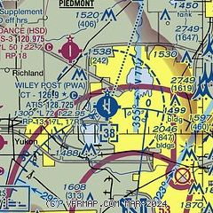
|
CAUTION: Diagram may not be current
 Download PDF
of official airport diagram from the FAA
| Airport distance calculator |
|---|
|
|
| Sunrise and sunset |
|---|
|
Times for 19-Apr-2024
| | Local
(UTC-5) | | Zulu
(UTC) |
|---|
| Morning civil twilight | | 06:26 | | 11:26 |
| Sunrise | | 06:53 | | 11:53 |
| Sunset | | 20:07 | | 01:07 |
| Evening civil twilight | | 20:33 | | 01:33 |
|
| Current date and time |
|---|
| Zulu (UTC) | 19-Apr-2024 05:14:14 |
|---|
| Local (UTC-5) | 19-Apr-2024 00:14:14 |
|---|
|
| METAR |
|---|
| KPWA | 190453Z AUTO 03017G30KT 10SM BKN040 12/06 A3015 RMK AO2 PK WND 03031/0440 SLP206 T01170061 $
|
KHSD
5nm NW | 190455Z AUTO 03016G21KT 10SM BKN043 11/07 A3016 RMK A01
|
KRCE
9nm W | 190455Z AUTO 03015G22KT 10SM OVC039 11/06 A3016 RMK AO2 TSNO
|
KOKC
9nm S | 190452Z 02013G22KT 10SM FEW025 OVC036 12/06 A3014 RMK AO2 SLP202 T01220061
|
KTIK
15nm SE | 190455Z AUTO 03013KT 10SM SCT026 SCT032 12/06 A3010 RMK AO2 SLP194 T01220063
|
KRQO
18nm W | 190455Z AUTO 03016G21KT 10SM OVC039 11/06 A3018 RMK AO2 T01120062
|
|
| TAF |
|---|
KOKC
9nm S | 182357Z 1900/1924 36020KT P6SM OVC025 FM190700 03015KT P6SM SCT030 SCT250 FM191500 05020G30KT P6SM SCT250 FM191800 05015KT P6SM BKN250
|
KTIK
15nm SE | 190108Z 1901/2007 02015G20KT 9999 BKN025 QNH3003INS BECMG 1904/1905 02012KT 9999 BKN030 QNH3010INS BECMG 1914/1915 04015G20KT 9999 FEW060 SCT250 QNH3013INS BECMG 1920/1921 05009KT 9999 SCT250 QNH3004INS TX20/1922Z TN09/1912Z
|
|
| NOTAMs |
|---|
NOTAMs are issued by the DoD/FAA and will open in a separate window not controlled by AirNav.
|
|


