FAA INFORMATION EFFECTIVE 18 APRIL 2024
Location
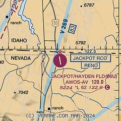
| FAA Identifier: | 06U |
| Lat/Long: | 41-58-32.9856N 114-39-28.8567W
41-58.549760N 114-39.480945W
41.9758293,-114.6580158
(estimated) |
| Elevation: | 5224.1 ft. / 1592.3 m (surveyed) |
| Variation: | 16E (1985) |
| Time zone: | UTC -7 (UTC -8 during Standard Time) |
| Zip code: | 89825 |
Airport Operations
| Airport use: | Open to the public |
| Activation date: | 08/1962 |
| Control tower: | no |
| ARTCC: | SALT LAKE CITY CENTER |
| FSS: | RENO FLIGHT SERVICE STATION |
| NOTAMs facility: | RNO (NOTAM-D service available) |
| Attendance: | ON CALL |
| Wind indicator: | lighted |
| Segmented circle: | yes |
| Lights: | ACTVT REIL RWY 15 & 33; PAPI RWY 15 & 33; MIRL RWY 15/33 - CTAF. |
| Beacon: | white-green (lighted land airport)
SS-SR. BCN VIS LTD FM WEST. |
Airport Communications
| CTAF/UNICOM: | 122.8 |
| WX AWOS-AV: | 120.00 (775-755-2297) |
Nearby radio navigation aids
| VOR radial/distance | | VOR name | | Freq | | Var |
|---|
| TWFr176/31.2 | | TWIN FALLS VORTAC | | 113.10 | | 18E |
Airport Services
| Parking: | tiedowns |
| Airframe service: | NONE |
| Powerplant service: | NONE |
| Bottled oxygen: | NONE |
| Bulk oxygen: | NONE |
Runway Information
Runway 15/33
| Dimensions: | 6183 x 60 ft. / 1885 x 18 m |
| Surface: | asphalt, in fair condition |
| Weight bearing capacity: | |
| Runway edge lights: | medium intensity |
| RUNWAY 15 | | RUNWAY 33 |
| Latitude: | 41-59.037257N | | 41-58.062262N |
| Longitude: | 114-39.676328W | | 114-39.285562W |
| Elevation: | 5224.1 ft. | | 5174.9 ft. |
| Traffic pattern: | left | | left |
| Markings: | nonprecision, in good condition | | nonprecision, in good condition |
| Visual slope indicator: | 2-light PAPI on left (4.00 degrees glide path) | | 2-light PAPI on left (3.50 degrees glide path) |
| Runway end identifier lights: | yes | | yes |
| Touchdown point: | yes, no lights | | yes, no lights |
| Obstructions: | 54 ft. trees, 1800 ft. from runway, 100 ft. left of centerline, 29:1 slope to clear | | 200 ft. hill, lighted, 5000 ft. from runway, 24:1 slope to clear |
Airport Ownership and Management from official FAA records
| Ownership: | Publicly-owned |
| Owner: | ELKO COUNTY
540 COURT STREET, SUITE 104
ELKO, NV 89801
Phone 775-738-6816 |
| Manager: | SHAWN BURT
AIRPORT MANAGER, PO BOX 337
JACKPOT, NV 89825
Phone 775-755-2447 |
Airport Operational Statistics
| Aircraft operations: avg 77/week * | | 72% | transient general aviation | | 18% | military | | 10% | local general aviation | | * for 12-month period ending 31 May 2023 | |
Additional Remarks
| - | TERRAIN OBSTNS LCTD S & W OF ARPT. |
| - | BIRD HAZARD EAST OF ARPT AT PONDS. |
| - | FUEL NOT AVBL. |
| - | EMERGENCY CONTACT 208-731-2447 |
| - | IN NO WIND CONDS, RCMD DEP RWY 15, ARR RWY 33 FOR SLOPE. |
Instrument Procedures
There are no published instrument procedures at 06U.
Some nearby airports with instrument procedures:
KTWF - Joslin Field/Magic Valley Regional Airport (31 nm N)
KJER - Jerome County Airport (46 nm N)
KBYI - Burley Municipal Airport (52 nm NE)
KGNG - Gooding Municipal Airport (57 nm N)
10U - Owyhee Airport (68 nm W)
|
|

Road maps at:
MapQuest
Bing
Google
| Aerial photo |
|---|
WARNING: Photo may not be current or correct
 Photo by Stephen Turk
Photo taken 06-Dec-2007
Photo by Stephen Turk
Photo taken 06-Dec-2007
Do you have a better or more recent aerial photo of Jackpot Airport/Hayden Field that you would like to share? If so, please send us your photo.
|
| Sectional chart |
|---|
|
| Airport distance calculator |
|---|
|
|
| Sunrise and sunset |
|---|
|
Times for 24-Apr-2024
| | Local
(UTC-7) | | Zulu
(UTC) |
|---|
| Morning civil twilight | | 05:14 | | 12:14 |
| Sunrise | | 05:44 | | 12:44 |
| Sunset | | 19:29 | | 02:29 |
| Evening civil twilight | | 19:59 | | 02:59 |
|
| Current date and time |
|---|
| Zulu (UTC) | 24-Apr-2024 21:04:58 |
|---|
| Local (UTC-7) | 24-Apr-2024 14:04:58 |
|---|
|
| METAR |
|---|
KTWF
31nm N | 242053Z 31006KT 10SM CLR 20/05 A2989 RMK AO2 SLP086 T02000050 58018
|
KJER
45nm N | 242053Z AUTO 26007KT 10SM CLR 19/03 A2988 RMK AO2 RAB14E23 SLP098 P0000 60000 T01940033 58019
|
|
| TAF |
|---|
KTWF
31nm N | 241720Z 2418/2518 VRB06KT P6SM BKN100 FM242000 24010G18KT P6SM VCTS BKN070CB FM250200 23012KT P6SM VCSH BKN070 FM251100 25014G24KT P6SM VCSH BKN070
|
|
| NOTAMs |
|---|
NOTAMs are issued by the DoD/FAA and will open in a separate window not controlled by AirNav.
|
|

