FAA INFORMATION EFFECTIVE 16 APRIL 2026
Location
| FAA Identifier: | 11R |
| Lat/Long: | 30-13-10.8318N 096-22-27.8500W
30-13.180530N 096-22.464167W
30.2196755,-96.3744028
(estimated) |
| Elevation: | 317.7 ft. / 97 m (estimated) |
| Variation: | 06E (1985) |
| From city: | 3 miles NE of BRENHAM, TX |
| Time zone: | UTC -5 (UTC -6 during Standard Time) |
| Zip code: | 77833 |
Airport Operations
| Airport use: | Open to the public |
| Activation date: | 10/1965 |
| Control tower: | no |
| ARTCC: | HOUSTON CENTER |
| FSS: | MONTGOMERY COUNTY FLIGHT SERVICE STATION |
| NOTAMs facility: | 11R (NOTAM-D service available) |
| Attendance: | MON - FRI 0800-1700 |
| Wind indicator: | lighted |
| Segmented circle: | yes |
| Lights: | MIRL RWY 16/34 PRESET MED SS-SR. TO ACTVT & INCR INTST - CTAF. |
| Beacon: | white-green (lighted land airport)
Operates sunset to sunrise. |
Airport Communications
| CTAF/UNICOM: | 123.075 |
| WX AWOS-3: | 121.125 (979-836-2303) |
| HOUSTON APPROACH: | 134.3 |
| HOUSTON DEPARTURE: | 134.3 |
| WX AWOS-3PT at 60R (16 nm NE): | 120.925 (936-825-0798) |
Nearby radio navigation aids
| VOR radial/distance | | VOR name | | Freq | | Var |
|---|
| TNVr248/16.9 | | NAVASOTA VOR/DME | | 115.90 | | 08E |
| CLLr166/23.2 | | COLLEGE STATION VORTAC | | 113.30 | | 08E |
Airport Services
| Fuel available: | 100LL JET-A+
100LL:FUEL 24 HR SELF-SERV. FULL SVC AVBL DURG ATNDD HRS. FOR AFT HRS SVC 979-337-7245, CALL-IN FEE. |
| Parking: | tiedowns |
| Airframe service: | MAJOR |
| Powerplant service: | MAJOR |
| Bottled oxygen: | LOW |
Runway Information
Runway 16/34
| Dimensions: | 6003 x 75 ft. / 1830 x 23 m |
| Surface: | asphalt, in fair condition |
| Weight bearing capacity: | |
| Runway edge lights: | medium intensity |
| RUNWAY 16 | | RUNWAY 34 |
| Latitude: | 30-13.670000N | | 30-12.691060N |
| Longitude: | 096-22.550167W | | 096-22.378167W |
| Elevation: | 317.7 ft. | | 250.4 ft. |
| Traffic pattern: | left | | left |
| Runway heading: | 165 magnetic, 171 true | | 345 magnetic, 351 true |
| Markings: | nonprecision, in fair condition | | nonprecision, in fair condition |
| Visual slope indicator: | 2-light PAPI on left (3.00 degrees glide path) | | 4-light PAPI on left (3.50 degrees glide path) |
| Runway end identifier lights: | yes | | yes |
| Touchdown point: | yes, no lights | | yes, no lights |
| Obstructions: | 35 ft. tree, 800 ft. from runway, 225 ft. right of centerline, 17:1 slope to clear | | 37 ft. trees, 760 ft. from runway, 220 ft. left of centerline, 15:1 slope to clear |
Airport Ownership and Management from official FAA records
| Ownership: | Publicly-owned |
| Owner: | CITY OF BRENHAM
PO BOX 1059
BRENHAM, TX 77834
Phone 979-337-7576 |
| Manager: | MEGAN MAINER
3001 AVIATION WAY
BRENHAM, TX 77833
Phone 979-337-7232 |
Additional Remarks
| - | FOR CD CTC HOUSTON APCH AT 281-443-5844 TO CNL IFR CALL 281-443-5888. |
| - | 94 FT LGTD RADAR ANT, 1060 FT WEST OF RWY 16 END. |
Instrument Procedures
NOTE: All procedures below are presented as PDF files. If you need a reader for these files, you should download the free Adobe Reader.NOT FOR NAVIGATION. Please procure official charts for flight.
FAA instrument procedures published for use from 16 April 2026 at 0901Z to 14 May 2026 at 0900Z.
IAPs - Instrument Approach Procedures |
|---|
| RNAV (GPS) RWY 16 | |
download (214KB) |
| RNAV (GPS) RWY 34 | |
download (213KB) |
| NOTE: Special Alternate Minimums apply | |
download |
| NOTE: Special Take-Off Minimums/Departure Procedures apply | |
download (70KB) |
Other nearby airports with instrument procedures:
60R - Navasota Municipal Airport (16 nm NE)
KCLL - Easterwood Field Airport (22 nm N)
KRWV - Caldwell Municipal Airport (25 nm NW)
KCFD - Coulter Field Airport (30 nm N)
KGYB - Giddings-Lee County Airport (32 nm W)
|
|

Road maps at:
MapQuest
Bing
Google
| Aerial photo |
|---|
WARNING: Photo may not be current or correct
 Photo by Brent N
Photo taken 25-Sep-2019
looking north.
Photo by Brent N
Photo taken 25-Sep-2019
looking north.
Do you have a better or more recent aerial photo of Brenham Municipal Airport that you would like to share? If so, please send us your photo.
|
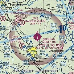
| Sectional chart |
|---|
|
CAUTION: Diagram may not be current

| Airport distance calculator |
|---|
|
|
| Sunrise and sunset |
|---|
|
Times for 06-May-2026
| | Local
(UTC-5) | | Zulu
(UTC) |
|---|
| Morning civil twilight | | 06:13 | | 11:13 |
| Sunrise | | 06:39 | | 11:39 |
| Sunset | | 20:05 | | 01:05 |
| Evening civil twilight | | 20:31 | | 01:31 |
|
| Current date and time |
|---|
| Zulu (UTC) | 06-May-2026 06:50:10 |
|---|
| Local (UTC-5) | 06-May-2026 01:50:10 |
|---|
|
| METAR |
|---|
| K11R | 060635Z AUTO 17007KT 7SM OVC013 24/23 A2979 RMK AO2 T02420225
|
|
| TAF |
|---|
KCLL
22nm N | 060521Z 0606/0706 18011KT P6SM SCT020 OVC040 FM060800 16011KT P6SM OVC015 FM061000 17007KT P6SM BKN007 OVC010 FM061800 25008KT P6SM VCSH BKN015 FM062200 34007KT P6SM VCSH BKN015 FM070300 01006KT P6SM SCT008 OVC015
|
|
| NOTAMs |
|---|
NOTAMs are issued by the DoD/FAA and will open in a separate window not controlled by AirNav.
|
|


