FAA INFORMATION EFFECTIVE 11 JUNE 2026
Location
| FAA Identifier: | 12V |
| Lat/Long: | 38-26-27.2000N 082-12-02.8000W
38-26.453333N 082-12.046667W
38.4408889,-82.2007778
(estimated) |
| Elevation: | 571.7 ft. / 174.3 m (surveyed) |
| Variation: | 06W (2000) |
| From city: | 4 miles W of MILTON, WV |
| Time zone: | UTC -4 (UTC -5 during Standard Time) |
| Zip code: | 25545 |
Airport Operations
| Airport use: | Open to the public |
| Activation date: | 09/1987 |
| Control tower: | no |
| ARTCC: | INDIANAPOLIS CENTER |
| FSS: | ELKINS FLIGHT SERVICE STATION [703-724-4288] |
| NOTAMs facility: | EKN (NOTAM-D service available) |
| Attendance: | CONTINUOUS |
| Wind indicator: | yes |
| Segmented circle: | no |
| Lights: | SS-SR |
Airport Communications
| CTAF/UNICOM: | 122.8 |
| HUNTINGTON APPROACH: | 124.1 ;EAST 119.75 ;WEST |
| HUNTINGTON DEPARTURE: | 124.1 ;EAST 119.75 ;WEST |
| WX ASOS at HTS (17 nm W): | PHONE 681-432-1499 |
- APPROACHES FROM THE EAST USE CHARLESTON APCH 124.1/269.125. APPROACHES FROM THE WEST USE HUNTINGTON APCH 119.75/270.1.
Nearby radio navigation aids
| VOR radial/distance | | VOR name | | Freq | | Var |
|---|
| HVQr288/21.0 | | CHARLESTON VOR/DME | | 117.40 | | 03W |
Airport Services
| Fuel available: | 100LL
100LL:24 HR SELF-SERVE. |
| Parking: | hangars and tiedowns |
| Airframe service: | MAJOR |
| Powerplant service: | MAJOR |
Runway Information
Runway 7/25
| Dimensions: | 3154 x 40 ft. / 961 x 12 m |
| Surface: | asphalt, in fair condition |
| Runway edge lights: | non-standard
NSTD LIRL LIGHTS, NSTD SPACING AND COLORS. |
| RUNWAY 7 | | RUNWAY 25 |
| Latitude: | 38-26.320483N | | 38-26.586017N |
| Longitude: | 082-12.330133W | | 082-11.762300W |
| Elevation: | 567.1 ft. | | 569.4 ft. |
| Traffic pattern: | left | | left |
| Runway heading: | 065 magnetic, 059 true | | 245 magnetic, 239 true |
| Markings: | basic, in fair condition | | basic, in fair condition |
| Touchdown point: | yes, no lights | | yes, no lights |
| Obstructions: | 4 ft. fence, 201 ft. from runway, 1122 ft. left of centerline
ALSO 75 FT TREE, 615 FT DSTC, 28 FT L, OBSTN CLNC SLOPE 5:1. | | 40 ft. trees, 201 ft. from runway, 60 ft. left of centerline
20 FT HILL, 200 FT FM RWY END, 172 FT RIGHT, 40 FT TREES, 200 DSTC, 60-247 FT L. |
Airport Ownership and Management from official FAA records
| Ownership: | Privately-owned |
| Owner: | ONA LAND MANAGEMENT SERVICES, LLC
#1 FAIR SKIES DR
ONA, WV 25545-1500
Phone 954-328-7646 |
| Manager: | BILL & LYNN BAUER
# 1 FAIR SKIES DR.
ONA, WV 25545-1500
Phone 954-328-7646 |
Additional Remarks
| A52-09 | +350 HILL 1300 FT DSTC. |
| - | VEHICLES CROSSING RWY. |
| - | FOR CD CTC HUNTINGTON ATCT AT 304-453-2490. |
| - | NOISE ABATEMENT PROCEDURES IN EFFECT; DEP RWY 25 FLY 240 DEGS & DEP RWY 07 FLY 090 DEGS TO 1600 FT ALTITUDE. |
| - | RWY EXIT TO RAMP HAS DEPRESSION. |
| - | FENCE, POLES, BLDGS, IN PRIMARY SFC, WEST SIDE. |
| - | RACE TRACK ADJACENT TO RWY 07/25. |
Instrument Procedures
NOTE: All procedures below are presented as PDF files. If you need a reader for these files, you should download the free Adobe Reader.NOT FOR NAVIGATION. Please procure official charts for flight.
FAA instrument procedures published for use from 11 June 2026 at 0901Z to 09 July 2026 at 0900z.
IAPs - Instrument Approach Procedures |
|---|
| RNAV (GPS)-A | |
download (150KB) |
| VOR-A | |
download (162KB) |
| NOTE: Special Take-Off Minimums/Departure Procedures apply | |
download (149KB) |
Other nearby airports with instrument procedures:
KHTS - Tri-State Airport/Milton J. Ferguson Field (17 nm W)
KGAS - Gallia-Meigs Regional Airport (24 nm N)
KDWU - Ashland Regional Airport (26 nm W)
3I2 - Mason County Airport (29 nm N)
KCRW - West Virginia International Yeager Airport (29 nm E)
|
|

Road maps at:
MapQuest
Bing
Google
| Aerial photo |
|---|
WARNING: Photo may not be current or correct
 Photo taken 30-Oct-2005
taken from a Tri-Pacer
Photo taken 30-Oct-2005
taken from a Tri-Pacer
Do you have a better or more recent aerial photo of Ona Airpark that you would like to share? If so, please send us your photo.
|
| Sectional chart |
|---|
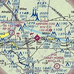
|
| Airport distance calculator |
|---|
|
|
| Sunrise and sunset |
|---|
|
Times for 25-Jun-2026
| | Local
(UTC-4) | | Zulu
(UTC) |
|---|
| Morning civil twilight | | 05:35 | | 09:35 |
| Sunrise | | 06:07 | | 10:07 |
| Sunset | | 20:56 | | 00:56 |
| Evening civil twilight | | 21:27 | | 01:27 |
|
| Current date and time |
|---|
| Zulu (UTC) | 25-Jun-2026 11:36:04 |
|---|
| Local (UTC-4) | 25-Jun-2026 07:36:04 |
|---|
|
| METAR |
|---|
KHTS
17nm W | 251051Z 00000KT 10SM CLR 18/16 A3004 RMK AO2 SLP164 T01780161 $
|
KDWU
26nm W | 251056Z AUTO 10SM CLR 17/14 A3004 RMK AO2 SLP168 T01670144 $
|
KCRW
29nm E | 251054Z 00000KT 10SM FEW000 SCT050 BKN100 14/14 A3005 RMK AO2 SLP169 FG FEW000 T01440144 $
|
|
| TAF |
|---|
KHTS
17nm W | 250540Z 2506/2606 00000KT P6SM BKN200 FM251100 19004KT P6SM FEW220 FM251500 23006KT P6SM SCT050 FM260100 00000KT P6SM SCT220
|
|
| NOTAMs |
|---|
NOTAMs are issued by the DoD/FAA and will open in a separate window not controlled by AirNav.
|
|

