FAA INFORMATION EFFECTIVE 14 MAY 2026
Location
| FAA Identifier: | 14A |
| Lat/Long: | 35-36-49.9300N 080-53-57.9500W
35-36.832167N 080-53.965833W
35.6138694,-80.8994306
(estimated) |
| Elevation: | 839.4 ft. / 255.8 m (surveyed) |
| Variation: | 07W (2005) |
| From city: | 5 miles NW of MOORESVILLE, NC |
| Time zone: | UTC -4 (UTC -5 during Standard Time) |
| Zip code: | 28117 |
Airport Operations
| Airport use: | Open to the public |
| Activation date: | 06/1967 |
| Control tower: | no |
| ARTCC: | ATLANTA CENTER |
| FSS: | RALEIGH FLIGHT SERVICE STATION |
| NOTAMs facility: | RDU (NOTAM-D service available) |
| Attendance: | MON - FRI 0800-1700, ALL SAT - SUN 1000-1600
ARPT UNATNDD ALL MAJ HOLS. |
| Wind indicator: | yes |
| Segmented circle: | yes
UNLGTD SEGMENTED CRC. |
| Lights: | ACTVT MIRL RWY 14/32 - CTAF (7 CLICKS). |
| Beacon: | white-green (lighted land airport)
Operates sunset to sunrise. |
Airport Communications
| CTAF/UNICOM: | 122.8 |
| CHARLOTTE APPROACH: | 134.75 |
| CHARLOTTE DEPARTURE: | 134.75 |
| WX AWOS-3 at SVH (9 nm N): | 119.225 (704-873-1978) |
| WX AWOS-3 at IPJ (15 nm SW): | 119.675 (704-735-6954) |
| WX AWOS-3 at JQF (16 nm SE): | 133.675 (704-785-2145) |
| WX AWOS-3P at RUQ (19 nm E): | 118.175 (704-637-6197) |
Nearby radio navigation aids
| VOR radial/distance | | VOR name | | Freq | | Var |
|---|
| BZMr139/22.6 | | BARRETTS MOUNTAIN VOR/DME | | 113.75 | | 06W |
| CLTr011/25.5 | | CHARLOTTE VOR/DME | | 115.00 | | 05W |
| NDB name | | Hdg/Dist | | Freq | | Var | | ID |
|---|
| STONIA | | 033/28.3 | | 260 | | 06W | | GHJ | --. .... .--- |
| FIDDLERS | | 106/38.1 | | 391 | | 07W | | FIQ | ..-. .. --.- |
Airport Services
| Fuel available: | 100LL |
| Parking: | hangars and tiedowns |
| Airframe service: | MAJOR |
| Powerplant service: | MAJOR |
| Bottled oxygen: | NONE |
| Bulk oxygen: | NONE |
Runway Information
Runway 14/32
| Dimensions: | 3147 x 40 ft. / 959 x 12 m |
| Surface: | asphalt, in good condition |
| Weight bearing capacity: | |
| Runway edge lights: | medium intensity
RWY 14 HAS DSPLCD THR LIGHTS BUT NO LIGHTS AT BEGINNING OF PAVEMENT. |
| Runway edge markings: | RWY 14/32 NUMBERS NSTD SIZE. |
| RUNWAY 14 | | RUNWAY 32 |
| Latitude: | 35-37.020667N | | 35-36.643667N |
| Longitude: | 080-54.184167W | | 080-53.747667W |
| Elevation: | 808.0 ft. | | 839.4 ft. |
| Traffic pattern: | left | | left |
| Displaced threshold: | 185 ft. | | no |
| Markings: | NSTD, in good condition | | NSTD, in good condition |
| Runway end identifier lights: | no | | no |
| Touchdown point: | yes, no lights | | yes, no lights |
| Obstructions: | 82 ft. trees, 673 ft. from runway, 262 ft. left of centerline, 5:1 slope to clear
+10 FT TERRAIN 100 FT FM THR, 50 FT LEFT OF CNTRLN, AND 20 FT SUPPL LDI (TET) 100 FT FM THR, 100 FT LEFT OF CNTRLN. | | 42 ft. trees, 469 ft. from runway, 132 ft. right of centerline, 6:1 slope to clear
+48 TREES LINE 0-200 FT FM THR OFFSET 116 FT RIGHT. |
Airport Ownership and Management from official FAA records
| Ownership: | Privately-owned |
| Owner: | LAKE NORMAN AIRPARK OWNERS ASSOC
409 NORMANDY ROAD
MOORESVILLE, NC 28117-3732
Phone 704-880-1563 |
| Manager: | DEBBY DENNIS
341 NORMANDY ROAD
MOORESVILLE, NC 28117
Phone 704-880-1563 |
Additional Remarks
| - | ACFT TAXIING ON GRASS INVOF RESIDENTIAL AIRPARK HNGR ACCESS. |
| - | FOR CD CTC APCH AT 704-359-0241. CALL WHEN AT RWY READY FOR DEP. |
| - | CTC RACE CITY FLT OPS FOR TIEDOWN, HNGR, AND FUEL INFO AT 704-662-6227. |
| - | ACFT MAX WT 8000 LBS. |
| - | BACK TAXI ON RWY - NO PARL TWYS. |
| - | NO HEL TRG. |
| - | DEER INVOF RWY. |
| - | RWY 14 HAS UPHILL GRADE. |
| - | DEP RWY 14 HDG 160 DEGS TO AVOID SCHOOL. |
| - | NOISE SENSITIVE AREA AVOID DEPS BTN 2300 AND 0600. DEP RWY 32 HDG 324 DEG UNTIL OVER LAKE TO AVOID HOUSES. |
| - | RWY 32 HAS 10 FT DROP-OFF 5 FT FM LEFT SIDE OF PAVEMENT AND ACFT PARKED 200 FT FM END OF RWY 100 FT RIGHT OF CNTRLN. |
Instrument Procedures
NOTE: All procedures below are presented as PDF files. If you need a reader for these files, you should download the free Adobe Reader.NOT FOR NAVIGATION. Please procure official charts for flight.
FAA instrument procedures published for use from 14 May 2026 at 0901Z to 11 June 2026 at 0900Z.
IAPs - Instrument Approach Procedures |
|---|
| RNAV (GPS) RWY 14 | |
download (223KB) |
| NOTE: Special Take-Off Minimums/Departure Procedures apply | |
download (141KB) |
Other nearby airports with instrument procedures:
KSVH - Statesville Regional Airport (9 nm N)
KIPJ - Lincoln County Regional Airport (15 nm SW)
KJQF - Concord-Padgett Regional Airport (16 nm SE)
KRUQ - Mid-Carolina Regional Airport (19 nm E)
KCLT - Charlotte/Douglas International Airport (24 nm S)
|
|

Road maps at:
MapQuest
Bing
Google
| Aerial photo |
|---|
WARNING: Photo may not be current or correct
 Photo by Race City Flight Operations
Photo taken 10-Jun-2019
looking northwest.
Photo by Race City Flight Operations
Photo taken 10-Jun-2019
looking northwest.
Do you have a better or more recent aerial photo of Lake Norman Airpark that you would like to share? If so, please send us your photo.
|
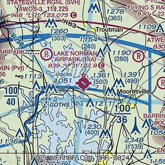
| Sectional chart |
|---|
|
| Airport distance calculator |
|---|
|
|
| Sunrise and sunset |
|---|
|
Times for 27-May-2026
| | Local
(UTC-4) | | Zulu
(UTC) |
|---|
| Morning civil twilight | | 05:43 | | 09:43 |
| Sunrise | | 06:12 | | 10:12 |
| Sunset | | 20:29 | | 00:29 |
| Evening civil twilight | | 20:59 | | 00:59 |
|
| Current date and time |
|---|
| Zulu (UTC) | 27-May-2026 15:38:28 |
|---|
| Local (UTC-4) | 27-May-2026 11:38:28 |
|---|
|
| METAR |
|---|
KSVH
9nm N | 271455Z AUTO 21006KT 10SM BKN012 OVC016 25/22 A3010 RMK AO2 T02480221
|
KIPJ
15nm SW | 271455Z AUTO 21006KT 10SM OVC010 23/21 A3010 RMK AO2 T02340212
|
KJQF
16nm SE | 271450Z 25007KT 10SM OVC008 23/21 A3013
|
KRUQ
19nm E | 271455Z AUTO 22005KT 10SM OVC010 23/21 A3009 RMK AO2 T02310206
|
|
| TAF |
|---|
KCLT
24nm S | 271356Z 2714/2818 23006KT P6SM FEW006 BKN015 TEMPO 2714/2715 BKN006 FM271500 23008KT P6SM BKN021 FM271700 23010G17KT P6SM BKN045 FM272200 23007KT P6SM SCT050 BKN100 PROB30 2722/2804 4SM TSRA BR OVC025CB FM280400 22005KT 6SM BR FEW015 BKN120
|
KHKY
25nm W | 271138Z 2712/2812 22005KT 5SM BR SCT005 OVC025 TEMPO 2712/2714 2SM BR BKN005 FM271400 22007KT P6SM BKN014 FM271700 22006KT P6SM VCSH BKN050 PROB30 2719/2723 4SM TSRA OVC025CB FM280000 24002KT P6SM SCT070
|
|
| NOTAMs |
|---|
NOTAMs are issued by the DoD/FAA and will open in a separate window not controlled by AirNav.
|
|

