FAA INFORMATION EFFECTIVE 30 OCTOBER 2025
Location
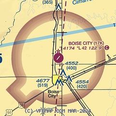
| FAA Identifier: | 17K |
| Lat/Long: | 36-46-27.5000N 102-30-37.6000W
36-46.458333N 102-30.626667W
36.7743056,-102.5104444
(estimated) |
| Elevation: | 4174.3 ft. / 1272.3 m (surveyed) |
| Variation: | 09E (1995) |
| From city: | 3 miles N of BOISE CITY, OK |
| Time zone: | UTC -6 (UTC -5 during Daylight Saving Time) |
| Zip code: | 73933 |
Airport Operations
| Airport use: | Open to the public |
| Activation date: | 08/1946 |
| Control tower: | no |
| ARTCC: | ALBUQUERQUE CENTER |
| FSS: | MC ALESTER FLIGHT SERVICE STATION |
| NOTAMs facility: | MLC (NOTAM-D service available) |
| Attendance: | UNATNDD |
| Wind indicator: | lighted |
| Segmented circle: | yes |
| Lights: | ACTVT PAPI RWY 04 & 22 - CTAF. MIRL RWY 04/22 SS-SR; PRESET LOW INTST; INCR INTST - CTAF. |
| Beacon: | white-green (lighted land airport)
Operates sunset to sunrise. |
Airport Communications
- APCH/DEP SVC PRVDD BY ALBUQUERQUE ARTCC (ABQ) ON FREQS 127.85/285.475 (MOUNT DORA RCAG).
Airport Services
| Fuel available: | 100LL JET-A JET-A+
100LL:FUEL AVBL 24HRS W/ CC. |
| Parking: | tiedowns |
| Airframe service: | NONE |
| Powerplant service: | NONE |
| Bottled oxygen: | NONE |
| Bulk oxygen: | NONE |
Runway Information
Runway 4/22
| Dimensions: | 4211 x 60 ft. / 1284 x 18 m |
| Surface: | asphalt, in excellent condition |
| Weight bearing capacity: | |
| Runway edge lights: | medium intensity |
| RUNWAY 4 | | RUNWAY 22 |
| Latitude: | 36-46.232803N | | 36-46.683457N |
| Longitude: | 102-30.953885W | | 102-30.298213W |
| Elevation: | 4171.7 ft. | | 4164.3 ft. |
| Traffic pattern: | left | | left |
| Runway heading: | 040 magnetic, 049 true | | 220 magnetic, 229 true |
| Markings: | nonprecision, in good condition | | nonprecision, in good condition |
| Visual slope indicator: | 4-light PAPI on left (3.00 degrees glide path)
PAPI UNUSBL BYD 5 DEGS LEFT OF CNTRLN. | | 4-light PAPI on left (3.00 degrees glide path) |
| Touchdown point: | yes, no lights | | yes, no lights |
| Obstructions: | 22 ft. trees, 234 ft. from runway, 204 ft. right of centerline, 1:1 slope to clear
20 FT TREELINE CROSSES RWY 04 APCH. | | 15 ft. road, 450 ft. from runway, 16:1 slope to clear |
Airport Ownership and Management from official FAA records
| Ownership: | Publicly-owned |
| Owner: | CITY OF BOISE CITY
P.O. BOX 129, 23 N. LOGAN
BOISE CITY, OK 73933
Phone 580-544-2271 |
| Manager: | HERMEN ESPARANZA
CITY HALL, P.O. BOX 129
BOISE CITY, OK 73933
Phone 580-544-2271 |
Additional Remarks
| - | FOR CD CTC ALBUQUERQUE ARTCC AT 505-856-4861. |
Instrument Procedures
NOTE: All procedures below are presented as PDF files. If you need a reader for these files, you should download the free Adobe Reader.NOT FOR NAVIGATION. Please procure official charts for flight.
FAA instrument procedures published for use from 30 October 2025 at 0901Z to 27 November 2025 at 0900Z.
IAPs - Instrument Approach Procedures |
|---|
| RNAV (GPS) RWY 04 | |
download (191KB) |
| NOTE: Special Take-Off Minimums/Departure Procedures apply | |
download (131KB) |
Other nearby airports with instrument procedures:
KEHA - Elkhart-Morton County Airport (33 nm NE)
KCAO - Clayton Municipal Airpark (37 nm SW)
8V7 - Springfield Municipal Airport (41 nm N)
KDHT - Dalhart Municipal Airport (45 nm S)
KGUY - Guymon Municipal Airport (49 nm E)
|
|

Road maps at:
MapQuest
Bing
Google
| Aerial photo |
|---|
WARNING: Photo may not be current or correct
 Photo by Ron Lee
Do you have a better or more recent aerial photo of Boise City Airport that you would like to share? If so, please send us your photo.
|
| Sectional chart |
|---|
|
| Airport distance calculator |
|---|
|
|
| Sunrise and sunset |
|---|
|
Times for 13-Nov-2025
| | Local
(UTC-6) | | Zulu
(UTC) |
|---|
| Morning civil twilight | | 07:00 | | 13:00 |
| Sunrise | | 07:27 | | 13:27 |
| Sunset | | 17:42 | | 23:42 |
| Evening civil twilight | | 18:09 | | 00:09 |
|
| Current date and time |
|---|
| Zulu (UTC) | 14-Nov-2025 05:09:59 |
|---|
| Local (UTC-6) | 13-Nov-2025 23:09:59 |
|---|
|
| METAR |
|---|
KSPD
31nm N | 140456Z AUTO 27004KT 05/M08 A3007 RMK AO1 SLP148 T00501078
|
KEHA
32nm NE | 132255Z AUTO 19006KT 10SM CLR 15/M02 A3004 RMK AO2 T01451022
|
KCAO
36nm SW | 140455Z AUTO 27010KT 10SM CLR 12/M09 A3012 RMK AO2 SLP154 T01171089 $
|
KDHT
45nm S | 140453Z AUTO 30006KT 10SM CLR 08/M04 A3008 RMK AO2 SLP153 T00781044
|
KGUY
49nm E | 140453Z AUTO 24006KT 10SM CLR 06/M02 A3001 RMK AO2 SLP144 T00561022
|
|
| TAF |
|---|
KDHT
45nm S | 131720Z 1318/1418 34008KT P6SM BKN250 FM140000 VRB06KT P6SM SCT250 FM140600 30006KT P6SM FEW250
|
KGUY
49nm E | 131720Z 1318/1418 34008KT P6SM BKN250 FM140000 VRB06KT P6SM SCT250 FM140700 26005KT P6SM FEW250
|
|
| NOTAMs |
|---|
NOTAMs are issued by the DoD/FAA and will open in a separate window not controlled by AirNav.
|
|


