FAA INFORMATION EFFECTIVE 18 APRIL 2024
Location
| FAA Identifier: | 17S |
| Lat/Long: | 45-19-25.4200N 123-03-15.3700W
45-19.423667N 123-03.256167W
45.3237278,-123.0542694
(estimated) |
| Elevation: | 190 ft. / 58 m (estimated) |
| Variation: | 19E (1985) |
| From city: | 4 miles NW of NEWBERG, OR |
| Time zone: | UTC -7 (UTC -8 during Standard Time) |
| Zip code: | 97132 |
Airport Operations
| Airport use: | Open to the public |
| Control tower: | no |
| ARTCC: | SEATTLE CENTER |
| FSS: | MC MINNVILLE FLIGHT SERVICE STATION |
| NOTAMs facility: | MMV (NOTAM-D service available) |
| Attendance: | 0800-1800 |
| Wind indicator: | yes |
| Segmented circle: | no |
| Lights: | SS-SR |
Airport Communications
| CTAF: | 122.9 |
| WX ASOS at MMV (8 nm SW): | 135.675 (503-434-9153) |
| WX ASOS at UAO (13 nm E): | 118.525 (503-678-3011) |
| WX ASOS at HIO (14 nm N): | PHONE 503-615-4314 |
Nearby radio navigation aids
| VOR radial/distance | | VOR name | | Freq | | Var |
|---|
| UBGr220/3.7 | | NEWBERG VOR/DME | | 117.40 | | 21E |
| BTGr196/32.0 | | BATTLE GROUND VORTAC | | 116.60 | | 21E |
| NDB name | | Hdg/Dist | | Freq | | Var | | ID |
|---|
| BANKS | | 165/18.4 | | 356 | | 16E | | PND | .--. -. -.. |
Airport Services
| Fuel available: | 100LL JET-A |
| Parking: | tiedowns |
| Airframe service: | MAJOR |
| Powerplant service: | MAJOR |
Runway Information
Runway 7/25
| Dimensions: | 2285 x 40 ft. / 696 x 12 m |
| Surface: | asphalt, in good condition |
| Runway edge lights: | non-standard
NSTD GREEN THLD LIGHTS AT WEST END ONLY; NO THLD LIGHTS ON EAST END; 300 FT DSPLCD THLD UNLIGHTED |
| Runway edge markings: | RWY 7/25 NSTD BASIC MARKINGS, NSTD SIZE, RWY EDGE STRIPES |
| RUNWAY 7 | | RUNWAY 25 |
| Traffic pattern: | left | | left |
| Displaced threshold: | 300 ft.
NSTD MARKINGS, NSTD SIZE. | | no |
| Markings: | NSTD, in good condition | | NSTD, in good condition |
| Obstructions: | 30 ft. pline, marked, 587 ft. from runway, 12:1 slope to clear
RWY 7 +13 FT ROAD 20 FR FRM RWY END, +18 FT BLDG 85 FT FRM RWY END & 65 FT L, 20 FT TREES/BRUSH 180 FT FRM RWY END, 53 FT TREES 60 FT FRM RWY END & 80 FEET L OF CENTERLINE | | 40 ft. tree, 811 ft. from runway, 105 ft. right of centerline, 15:1 slope to clear |
Airport Ownership and Management from official FAA records
| Ownership: | Privately-owned |
| Owner: | NANCY STURDEVANT
17600 NE AVIATION WAY
NEWBERG, OR 97132
Phone 503-538-1743 |
| Manager: | NANCY STURDEVANT
17770 NE AVIATION WAY
NEWBERG, OR 97132
Phone 503-537-0108 |
Airport Operational Statistics
| Aircraft based on the field: | | 31 | | Single engine airplanes: | | 20 | | Multi engine airplanes: | | 2 | | Helicopters: | | 9 |
| |  | |
| Aircraft operations: avg 34/day * | | 64% | transient general aviation | | 32% | local general aviation | | 4% | air taxi | | * for 12-month period ending 27 September 2021 | |
Additional Remarks
| - | RWY 25 HAS NOISE ABATEMENT PROCEDURES IN EFFECT FOR MORE INFORMATION CTC AMGR AT 503-537-0108. |
| - | NON STANDARD RUNWAY HOLD POSITION MARKINGS AT NORTH TAXIWAY ENTRANCE |
| - | FOR CD CTC PORTLAND APCH AT 503-493-7545. |
Instrument Procedures
There are no published instrument procedures at 17S.
Some nearby airports with instrument procedures:
KMMV - Mc Minnville Municipal Airport (8 nm SW)
KUAO - Aurora State Airport (13 nm E)
KHIO - Portland-Hillsboro Airport (14 nm N)
KVUO - Pearson Field Airport (24 nm NE)
KSLE - McNary Field Airport (25 nm S)
|
|

Road maps at:
MapQuest
Bing
Google
| Aerial photo |
|---|
WARNING: Photo may not be current or correct
 Taken in June 2007
Do you have a better or more recent aerial photo of Chehalem Airpark that you would like to share? If so, please send us your photo.
|
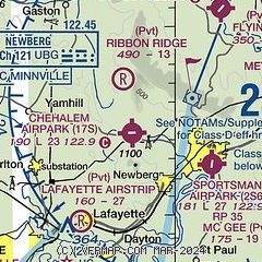
| Sectional chart |
|---|
|
| Airport distance calculator |
|---|
|
|
| Sunrise and sunset |
|---|
|
Times for 19-Apr-2024
| | Local
(UTC-7) | | Zulu
(UTC) |
|---|
| Morning civil twilight | | 05:48 | | 12:48 |
| Sunrise | | 06:19 | | 13:19 |
| Sunset | | 20:03 | | 03:03 |
| Evening civil twilight | | 20:35 | | 03:35 |
|
| Current date and time |
|---|
| Zulu (UTC) | 20-Apr-2024 04:40:38 |
|---|
| Local (UTC-7) | 19-Apr-2024 21:40:38 |
|---|
|
| METAR |
|---|
KUAO
13nm E | 200353Z AUTO 04007KT 10SM CLR 17/01 A2996 RMK AO2 SLP145 T01670006 $
|
KHIO
14nm N | 200353Z 07011KT 10SM CLR 17/M01 A2998 RMK AO2 SLP150 T01671011
|
|
| TAF |
|---|
KUAO
13nm E | 191738Z 1918/2018 04011KT P6SM SKC FM192000 04011G21KT P6SM SKC FM200300 04007KT P6SM SKC FM201500 11004KT P6SM BKN250
|
KHIO
14nm N | 191738Z 1918/2018 04014G25KT P6SM SKC FM200200 08007KT P6SM SKC FM201600 14006KT P6SM BKN250
|
|
| NOTAMs |
|---|
NOTAMs are issued by the DoD/FAA and will open in a separate window not controlled by AirNav.
|
|

