FAA INFORMATION EFFECTIVE 12 JUNE 2025
Location
| FAA Identifier: | 1U7 |
| Lat/Long: | 42-14-59.1400N 111-20-29.8580W
42-14.985667N 111-20.497633W
42.2497611,-111.3416272
(estimated) |
| Elevation: | 5932.9 ft. / 1808.3 m (surveyed) |
| Variation: | 11E (2020) |
| From city: | 3 miles E of PARIS, ID |
| Time zone: | UTC -6 (UTC -7 during Standard Time) |
| Zip code: | 83254 |
Airport Operations
| Airport use: | Open to the public |
| Activation date: | 02/1944 |
| Control tower: | no |
| ARTCC: | SALT LAKE CITY CENTER |
| FSS: | BOISE FLIGHT SERVICE STATION |
| NOTAMs facility: | BOI (NOTAM-D service available) |
| Attendance: | CONTINUOUS |
| Wind indicator: | lighted |
| Segmented circle: | yes |
| Lights: | ACTVT REIL RWY 10 & 28; MIRL RWY 10/28 - CTAF. |
| Beacon: | white-green (lighted land airport)
Operates sunset to sunrise. |
Airport Communications
| CTAF/UNICOM: | 122.8 |
| WX AWOS-3: | 118.525 (208 847 0613) |
- APCH/DEP CTL SVC PRVDD BY SALT LAKE ARTCC (ZLC) ON 128.35/239.25 BLACKFOOT RCAG.
Airport Services
| Fuel available: | 100LL
100LL:100 LL FUEL AVBL 24 HRS WITH CREDIT CARD SELF SVC. |
| Parking: | tiedowns |
| Airframe service: | NONE |
| Powerplant service: | NONE |
| Bottled oxygen: | NONE |
| Bulk oxygen: | NONE |
Runway Information
Runway 10/28
| Dimensions: | 5728 x 75 ft. / 1746 x 23 m |
| Surface: | asphalt, in excellent condition |
| Weight bearing capacity: | | Single wheel: | 14.0 | | Double wheel: | 28.0 | | Double tandem: | 60.0 |
|
| Runway edge lights: | medium intensity |
| RUNWAY 10 | | RUNWAY 28 |
| Latitude: | 42-15.284680N | | 42-14.884733N |
| Longitude: | 111-20.864695W | | 111-19.715520W |
| Elevation: | 5930.2 ft. | | 5932.9 ft. |
| Traffic pattern: | left | | left |
| Runway heading: | 104 magnetic, 115 true | | 284 magnetic, 295 true |
| Markings: | nonprecision, in good condition | | nonprecision, in good condition |
| Visual slope indicator: | 2-light PAPI on left (3.50 degrees glide path)
PAPI UNSUBL BYD 8 NM FM THR DUE TO MOUNTAINOUS TRRN. | | 2-light PAPI on left (3.50 degrees glide path) |
| Runway end identifier lights: | yes | | yes |
| Touchdown point: | yes, no lights | | yes, no lights |
| Obstructions: | 60 ft. pline, 2500 ft. from runway, 38:1 slope to clear | | 12 ft. road, 500 ft. from runway, 25:1 slope to clear |
Runway 16/34
| Dimensions: | 4590 x 60 ft. / 1399 x 18 m |
| Surface: | asphalt, in good condition |
| Weight bearing capacity: | | Single wheel: | 50.0 | | Double wheel: | 64.0 | | Double tandem: | 102.0 |
|
| Runway edge markings: | RUNWAY 16/34 HAS RUNWAY SIDE STRIPE MARKING |
| Operational restrictions: | NO SNOW REMOVAL RWY 16/34. |
| RUNWAY 16 | | RUNWAY 34 |
| Latitude: | 42-15.238423N | | 42-14.485672N |
| Longitude: | 111-20.800007W | | 111-20.713093W |
| Elevation: | 5930.0 ft. | | 5929.6 ft. |
| Traffic pattern: | left | | left |
| Runway heading: | 164 magnetic, 175 true | | 344 magnetic, 355 true |
| Markings: | basic, in good condition | | basic, in good condition |
| Touchdown point: | yes, no lights | | yes, no lights |
Airport Ownership and Management from official FAA records
| Ownership: | Publicly-owned |
| Owner: | BEAR LAKE COUNTY
PO BOX 190
PARIS, ID 83261
Phone 208-945-2212 |
| Manager: | TREVOR KEETCH
P O BOX 163
MONTPELIER, ID 83254
Phone 208-223-0416
208-223-0416 CELL, AVBL 24 HRS. |
Additional Remarks
| - | BIRDS ON & INVOF OF ARPT. |
| - | REFLECTORS ON ALL TWYS AND APRONS. |
| - | PARTIAL TWY 25 FT WIDE. |
| - | NO SNOW REMOVAL RWY 16/34. |
| - | FOR CD CTC SALT LAKE ARTCC AT 801-320-2568. |
| - | COLD TEMPERATURE AIRPORT. ALTITUDE CORRECTION REQUIRED AT OR BELOW -22C. |
Instrument Procedures
NOTE: All procedures below are presented as PDF files. If you need a reader for these files, you should download the free Adobe Reader.NOT FOR NAVIGATION. Please procure official charts for flight.
FAA instrument procedures published for use from 12 June 2025 at 0901Z to 10 July 2025 at 0900z.
IAPs - Instrument Approach Procedures |
|---|
| RNAV (GPS) RWY 10 **CHANGED** | |
download (342KB) |
| RNAV (GPS) RWY 28 **CHANGED** | |
download (579KB) |
| NOTE: Special Alternate Minimums apply | |
download (210KB) |
|
|---|
| BEAR LAKE ONE (OBSTACLE) (RNAV) | |
download (136KB) |
| FIROS ONE (OBSTACLE) (RNAV) | |
download (144KB) |
| NOTE: Special Take-Off Minimums/Departure Procedures apply | |
download (455KB) |
Other nearby airports with instrument procedures:
KAFO - Afton Lincoln County Airport/General Boyd L Eddins Field (33 nm NE)
KLGU - Logan-Cache Airport (36 nm SW)
KEMM - Kemmerer Municipal Airport (43 nm SE)
KBMC - Brigham City Regional Airport (53 nm SW)
KBPI - Miley Memorial Field Airport (58 nm E)
|
|

Road maps at:
MapQuest
Bing
Google
| Aerial photo |
|---|
WARNING: Photo may not be current or correct

Do you have a better or more recent aerial photo of Bear Lake County Airport that you would like to share? If so, please send us your photo.
|
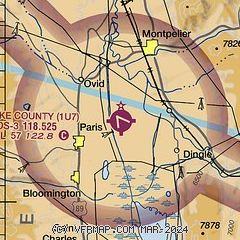
| Sectional chart |
|---|
|
| Airport distance calculator |
|---|
|
|
| Sunrise and sunset |
|---|
|
Times for 15-Jun-2025
| | Local
(UTC-6) | | Zulu
(UTC) |
|---|
| Morning civil twilight | | 05:15 | | 11:15 |
| Sunrise | | 05:49 | | 11:49 |
| Sunset | | 21:02 | | 03:02 |
| Evening civil twilight | | 21:37 | | 03:37 |
|
| Current date and time |
|---|
| Zulu (UTC) | 15-Jun-2025 15:54:40 |
|---|
| Local (UTC-6) | 15-Jun-2025 09:54:40 |
|---|
|
| METAR |
|---|
| K1U7 | 151515Z AUTO 13003KT 10SM CLR 18/09 A3015 RMK A01
|
|
| TAF |
|---|
KLGU
36nm SW | 151120Z 1512/1612 VRB05KT P6SM SCT200 FM151700 23009KT P6SM SCT200 FM160100 VRB04KT P6SM FEW200
|
|
| NOTAMs |
|---|
NOTAMs are issued by the DoD/FAA and will open in a separate window not controlled by AirNav.
|
|


