FAA INFORMATION EFFECTIVE 18 APRIL 2024
Location
| FAA Identifier: | 24C |
| Lat/Long: | 42-57-16.7700N 085-20-44.2200W
42-57.279500N 085-20.737000W
42.9546583,-85.3456167
(estimated) |
| Elevation: | 681 ft. / 207.6 m (surveyed) |
| Variation: | 04W (1985) |
| From city: | 1 mile N of LOWELL, MI |
| Time zone: | UTC -4 (UTC -5 during Standard Time) |
| Zip code: | 49331 |
Airport Operations
| Airport use: | Open to the public |
| Activation date: | 11/1946 |
| Control tower: | no |
| ARTCC: | CHICAGO CENTER |
| FSS: | LANSING FLIGHT SERVICE STATION |
| NOTAMs facility: | LAN (NOTAM-D service available) |
| Attendance: | 0900-1700 |
| Wind indicator: | lighted |
| Segmented circle: | yes |
| Lights: | ACTVT LIRL RWY 12/30 - CTAF. |
Airport Communications
| CTAF/UNICOM: | 123.0 |
| WX ASOS at GRR (9 nm SW): | PHONE 616-575-1953 |
| WX AWOS-3 at Y70 (13 nm E): | 118.9 (616-523-1852) |
| WX AWOS-AV at 8D4 (18 nm NW): | 132.95 |
Nearby radio navigation aids
| VOR radial/distance | | VOR name | | Freq | | Var |
|---|
| VIOr037/12.1 | | VICTORY VOR/DME | | 115.95 | | 04W |
| NDB name | | Hdg/Dist | | Freq | | Var | | ID |
|---|
| KNOBS | | 028/3.8 | | 263 | | 06W | | GR | --. .-. |
Airport Services
| Fuel available: | 100LL
100LL:AVBL H24 SELF SER CTC AMGR FOR DTLS. |
| Parking: | tiedowns |
| Airframe service: | NONE
RPRS ONLY AVBL ON CALL. |
| Powerplant service: | NONE |
| Bottled oxygen: | NONE |
| Bulk oxygen: | NONE |
Runway Information
Runway 12/30
| Dimensions: | 2394 x 48 ft. / 730 x 15 m |
| Surface: | asphalt, in poor condition
EXTSV CRACKING. |
| Runway edge lights: | low intensity |
| Runway edge markings: | NSTD DUE TO NR SPACING & DIMENSIONS. |
| RUNWAY 12 | | RUNWAY 30 |
| Latitude: | 42-57.407333N | | 42-57.251000N |
| Longitude: | 085-21.005667W | | 085-20.513167W |
| Elevation: | 681.0 ft. | | 681.0 ft. |
| Traffic pattern: | left | | left |
| Displaced threshold: | no | | 484 ft. |
| Markings: | NSTD, in good condition | | NSTD, in good condition |
| Obstructions: | 62 ft. trees, 380 ft. from runway, 140 ft. right of centerline, 2:1 slope to clear
APCH RATIO 20:1 BASED ON STRAIGHT OUT. | | 17 ft. bldg, 201 ft. from runway
50 FT TREES, 90 FT DIST, 90 FT R; 6 FT FENCE, 0 FT DIST, 125 FT R. |
Runway 6/24
| Dimensions: | 2700 x 100 ft. / 823 x 30 m |
| Surface: | turf, in fair condition |
| Runway edge markings: | RWY & DTHR MKD WITH 3 FT YELLOW CONES. |
| RUNWAY 6 | | RUNWAY 24 |
| Latitude: | 42-57.198833N | | 42-57.357667N |
| Longitude: | 085-21.074333W | | 085-20.509167W |
| Elevation: | 681.0 ft. | | 681.0 ft. |
| Traffic pattern: | left | | left |
| Runway heading: | 073 magnetic, 069 true | | 253 magnetic, 249 true |
| Displaced threshold: | 1100 ft. | | 1200 ft. |
| Touchdown point: | yes, no lights | | yes, no lights |
| Obstructions: | 40 ft. trees, 80 ft. right of centerline
APCH RATIO 22:1 TO DTHR OVR 54 FT TREE, 1225 FT DIST, BASED ON STRAIGHT OUT. | | 42 ft. trees, 100 ft. right of centerline
APCH RATIO 22:1 TO DTHR OVR 63 FT TREES, 1404 FT DIST, BASED ON STRAIGHT OUT. |
Runway 15/33
| Dimensions: | 1940 x 100 ft. / 591 x 30 m |
| Surface: | turf, in fair condition |
| Runway edge markings: | RWY & DTHR MKD WITH 3 FT YELLOW CONES. |
| RUNWAY 15 | | RUNWAY 33 |
| Latitude: | 42-57.362667N | | 42-57.077333N |
| Longitude: | 085-20.730667W | | 085-20.535333W |
| Elevation: | 679.0 ft. | | 679.0 ft. |
| Traffic pattern: | left | | left |
| Runway heading: | 157 magnetic, 153 true | | 337 magnetic, 333 true |
| Displaced threshold: | 582 ft. | | 388 ft. |
| Touchdown point: | yes, no lights | | yes, no lights |
| Obstructions: | 40 ft. trees, 90 ft. left of centerline
APCH RATIO 14:1 TO DTHR OVR 45 FT TREE, 1151 FT DIST, 50 FT L. | | 20 ft. pole, 15 ft. from runway, 120 ft. right of centerline
APCH RATIO 21:1 TO DTHR OVR 48 FT TREES, 1028 FT DIST, BASED ON STRAIGHT OUT. |
Airport Ownership and Management from official FAA records
| Ownership: | Publicly-owned |
| Owner: | CITY OF LOWELL
301 E MAIN ST
LOWELL, MI 49331-1759
Phone 616-897-8457 |
| Manager: | CASEY K BROWN
770 LINCOLN LAKE AVE SE
LOWELL, MI 49331-9421
Phone 616-987-0821 |
Airport Operational Statistics
| Aircraft based on the field: | | 31 | | Single engine airplanes: | | 29 | | Ultralights: | | 2 |
| |  | |
| Aircraft operations: avg 48/week * | | 80% | local general aviation | | 20% | transient general aviation | | * for 12-month period ending 31 December 2020 | |
Additional Remarks
| - | RWY 06/24 & 15/33 NO SNOW REMOVAL. |
| - | RWY 24, 80 FT TREE, 110 FT NORTH OF RWY END. |
| - | FOR CD CTC GREAT LAKES APCH AT 269-459-3344, WHEN APCH CLSD CTC CHICAGO ARTCC AT 630-906-8921. |
| - | DEER & LRG BIRDS ON & INVOF ARPT. |
Instrument Procedures
There are no published instrument procedures at 24C.
Some nearby airports with instrument procedures:
KGRR - Gerald R Ford International Airport (9 nm SW)
6D6 - Greenville Municipal Airport (12 nm N)
Y70 - Ionia County Airport (13 nm E)
9D9 - Hastings Airport (17 nm S)
8D4 - Paul C Miller/Sparta Airport (18 nm NW)
|
|

Road maps at:
MapQuest
Bing
Google
| Aerial photo |
|---|
WARNING: Photo may not be current or correct
 Photo by Ren Wall
Taken in August 2004
Photo by Ren Wall
Taken in August 2004
Do you have a better or more recent aerial photo of Lowell City Airport that you would like to share? If so, please send us your photo.
|
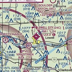
| Sectional chart |
|---|
|
| Airport distance calculator |
|---|
|
|
| Sunrise and sunset |
|---|
|
Times for 19-Apr-2024
| | Local
(UTC-4) | | Zulu
(UTC) |
|---|
| Morning civil twilight | | 06:23 | | 10:23 |
| Sunrise | | 06:53 | | 10:53 |
| Sunset | | 20:28 | | 00:28 |
| Evening civil twilight | | 20:58 | | 00:58 |
|
| Current date and time |
|---|
| Zulu (UTC) | 19-Apr-2024 23:36:17 |
|---|
| Local (UTC-4) | 19-Apr-2024 19:36:17 |
|---|
|
| METAR |
|---|
KGRR
9nm SW | 192253Z 26014G22KT 10SM FEW060 FEW200 10/M04 A3001 RMK AO2 PK WND 28026/2212 SLP166 T01001039
|
KY70
13nm E | 192315Z AUTO 26012G16KT 10SM CLR 10/M06 A3000 RMK AO2 T01001061
|
|
| TAF |
|---|
KGRR
9nm SW | 191730Z 1918/2018 27018G28KT P6SM FEW060 FM200100 27011KT P6SM SCT060
|
|
| NOTAMs |
|---|
NOTAMs are issued by the DoD/FAA and will open in a separate window not controlled by AirNav.
|
|
