FAA INFORMATION EFFECTIVE 16 APRIL 2026
Location
| FAA Identifier: | 24J |
| Lat/Long: | 30-18-01.4000N 083-01-27.8000W
30-18.023333N 083-01.463333W
30.3003889,-83.0243889
(estimated) |
| Elevation: | 103.3 ft. / 31.5 m (surveyed) |
| Variation: | 05W (2015) |
| From city: | 2 miles W of LIVE OAK, FL |
| Time zone: | UTC -4 (UTC -5 during Standard Time) |
| Zip code: | 32060 |
Airport Operations
| Airport use: | Open to the public |
| Activation date: | 07/1965 |
| Control tower: | no |
| ARTCC: | JACKSONVILLE CENTER |
| FSS: | GAINESVILLE FLIGHT SERVICE STATION |
| NOTAMs facility: | GNV (NOTAM-D service available) |
| Attendance: | MON-FRI 0800-1700 |
| Pattern altitude: | 1300.3 ft. MSL
TPA: 1197 FT AGL PROP, 1697 FT AGL TBJT. |
| Wind indicator: | lighted |
| Segmented circle: | yes |
| Lights: | ACTVT REIL RWY 07 & 25; PAPI RWY 07 & 25; MIRL RWY 07/25 - CTAF. |
| Beacon: | white-green (lighted land airport)
Operates sunset to sunrise. |
Airport Communications
| CTAF/UNICOM: | 122.8 |
| WX AWOS-3: | 118.225 (386-362-1731) |
- APCH/DEP SVC PRVDD BY JACKSONVILLE ARTCC ON FREQS 125.375/254.325 (LAKE CITY RCAG).
Nearby radio navigation aids
| VOR radial/distance | | VOR name | | Freq | | Var |
|---|
| OTKr157/31.7 | | VALDOSTA VOR/DME | | 114.80 | | 02W |
Airport Services
| Fuel available: | 100LL JET-A JET-A+ |
| Parking: | tiedowns |
| Airframe service: | MAJOR |
| Powerplant service: | MAJOR |
| Bottled oxygen: | NONE |
| Bulk oxygen: | NONE |
Runway Information
Runway 7/25
| Dimensions: | 4005 x 75 ft. / 1221 x 23 m |
| Surface: | asphalt, in fair condition |
| Weight bearing capacity: | | PCN 30 /F/A/W/T | | Single wheel: | 83.0 | | Double wheel: | 126.0 |
|
| Runway edge lights: | medium intensity |
| RUNWAY 7 | | RUNWAY 25 |
| Latitude: | 30-17.905678N | | 30-18.142248N |
| Longitude: | 083-01.818992W | | 083-01.108098W |
| Elevation: | 101.2 ft. | | 103.3 ft. |
| Traffic pattern: | left | | right |
| Runway heading: | 074 magnetic, 069 true | | 254 magnetic, 249 true |
| Markings: | nonprecision, in fair condition | | nonprecision, in fair condition |
| Visual slope indicator: | 2-light PAPI on left (3.00 degrees glide path) | | 2-light PAPI on left (3.00 degrees glide path) |
| Runway end identifier lights: | yes | | yes |
| Touchdown point: | yes, no lights | | yes, no lights |
| Obstructions: | 66 ft. trees, 1735 ft. from runway, 140 ft. left of centerline, 23:1 slope to clear | | 47 ft. trees, 1800 ft. from runway, 260 ft. left of centerline, 34:1 slope to clear |
Airport Ownership and Management from official FAA records
| Ownership: | Publicly-owned |
| Owner: | SUWANNEE COUNTY
13150 80TH TER
LIVE OAK, FL 32064
Phone 386-364-3400 |
| Manager: | JOHN DUHAIME
13302 80TH TER
LIVE OAK, FL 32060
Phone 386-362-4200 |
Additional Remarks
| - | FOR CD CTC JACKSONVILLE ARTCC AT 904-845-1592. |
Instrument Procedures
NOTE: All procedures below are presented as PDF files. If you need a reader for these files, you should download the free Adobe Reader.NOT FOR NAVIGATION. Please procure official charts for flight.
FAA instrument procedures published for use from 16 April 2026 at 0901Z to 14 May 2026 at 0900Z.
IAPs - Instrument Approach Procedures |
|---|
| RNAV (GPS) RWY 07 | |
download (187KB) |
| RNAV (GPS) RWY 25 | |
download (187KB) |
| NOTE: Special Alternate Minimums apply | |
download (157KB) |
| NOTE: Special Take-Off Minimums/Departure Procedures apply | |
download (169KB) |
Other nearby airports with instrument procedures:
KLCQ - Lake City Gateway Airport (24 nm E)
KVLD - Valdosta Regional Airport (32 nm NW)
KFPY - Perry-Foley Airport (32 nm SW)
KCTY - Cross City Airport (40 nm S)
KVAD - Moody Air Force Base (41 nm N)
|
|

Road maps at:
MapQuest
Bing
Google
| Aerial photo |
|---|
WARNING: Photo may not be current or correct
 Photo by Randal Geiger
Photo taken 17-Nov-2016
looking west
Photo by Randal Geiger
Photo taken 17-Nov-2016
looking west
Do you have a better or more recent aerial photo of Suwannee County Airport that you would like to share? If so, please send us your photo.
|
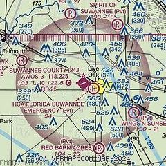
| Sectional chart |
|---|
|
CAUTION: Diagram may not be current

| Airport distance calculator |
|---|
|
|
| Sunrise and sunset |
|---|
|
Times for 10-May-2026
| | Local
(UTC-4) | | Zulu
(UTC) |
|---|
| Morning civil twilight | | 06:16 | | 10:16 |
| Sunrise | | 06:42 | | 10:42 |
| Sunset | | 20:15 | | 00:15 |
| Evening civil twilight | | 20:41 | | 00:41 |
|
| Current date and time |
|---|
| Zulu (UTC) | 10-May-2026 19:29:47 |
|---|
| Local (UTC-4) | 10-May-2026 15:29:47 |
|---|
|
| METAR |
|---|
| K24J | 101915Z AUTO VRB05KT 10SM SCT028 29/23 A2999 RMK A01
|
|
| TAF |
|---|
KVLD
31nm NW | 101720Z 1018/1118 06003KT P6SM SCT020 FM102000 18005KT P6SM VCSH SCT030 BKN045 FM110000 15003KT P6SM SCT040 OVC250 FM111000 00000KT 3SM BR BKN020 FM111400 27004KT P6SM SCT030 AMD NOT SKED
|
|
| NOTAMs |
|---|
NOTAMs are issued by the DoD/FAA and will open in a separate window not controlled by AirNav.
|
|


