FAA INFORMATION EFFECTIVE 18 APRIL 2024
Location
| FAA Identifier: | 25M |
| Lat/Long: | 34-43-21.8000N 089-00-52.9000W
34-43.363333N 089-00.881667W
34.7227222,-89.0146944
(estimated) |
| Elevation: | 466.9 ft. / 142.3 m (surveyed) |
| Variation: | 01W (2005) |
| From city: | 3 miles W of RIPLEY, MS |
| Time zone: | UTC -5 (UTC -6 during Standard Time) |
| Zip code: | 38663 |
Airport Operations
| Airport use: | Open to the public |
| Activation date: | 04/1971 |
| Control tower: | no |
| ARTCC: | MEMPHIS CENTER |
| FSS: | GREENWOOD FLIGHT SERVICE STATION |
| NOTAMs facility: | GWO (NOTAM-D service available) |
| Attendance: | UNATNDD |
| Wind indicator: | lighted |
| Segmented circle: | yes |
| Lights: | DUSK-2200. AFTER 2200 ACTVT PAPI RWY 03 & 21; MIRL RWY 03/21 - CTAF. |
| Beacon: | white-green (lighted land airport)
Operates sunset to sunrise. |
Airport Communications
- APCH/DEP SVC PRVDD BY MEMPHIS ARTCC ON FREQS 135.9/260.6 (TUPELO RCAG).
Nearby radio navigation aids
| VOR radial/distance | | VOR name | | Freq | | Var |
|---|
| HLIr094/23.9 | | HOLLY SPRINGS VORTAC | | 112.40 | | 03E |
| OTBr336/31.8 | | TUPELO VOR/DME | | 109.80 | | 04E |
Airport Services
| Fuel available: | 100LL JET-A
100LL:FUEL AVBL 24 HRS WITH CREDIT CARD. |
| Airframe service: | NONE |
| Powerplant service: | NONE |
| Bottled oxygen: | NONE |
| Bulk oxygen: | NONE |
Runway Information
Runway 3/21
| Dimensions: | 4400 x 75 ft. / 1341 x 23 m |
| Surface: | asphalt, in good condition |
| Weight bearing capacity: | |
| Runway edge lights: | medium intensity |
| RUNWAY 3 | | RUNWAY 21 |
| Latitude: | 34-43.055667N | | 34-43.672667N |
| Longitude: | 089-01.112667W | | 089-00.650500W |
| Elevation: | 433.0 ft. | | 466.8 ft. |
| Traffic pattern: | left | | left |
| Runway heading: | 033 magnetic, 032 true | | 213 magnetic, 212 true |
| Markings: | nonprecision, in fair condition | | nonprecision, in fair condition |
| Visual slope indicator: | 2-light PAPI on left (3.25 degrees glide path) | | 2-light PAPI on left (3.50 degrees glide path) |
| Touchdown point: | yes, no lights | | yes, no lights |
| Obstructions: | 65 ft. tree, 1500 ft. from runway, 300 ft. right of centerline, 20:1 slope to clear | | 65 ft. trees, 1505 ft. from runway, 253 ft. right of centerline, 20:1 slope to clear |
Airport Ownership and Management from official FAA records
| Ownership: | Publicly-owned |
| Owner: | CITY OF RIPLEY & TIPPAH COUNTY
407 JACKSON ST
RIPLEY, MS 38663
Phone 662-837-7374
JOHNNY COOMBS, CHAIRMAN CO ARPT BOARD. |
| Manager: | JOHNNY COOMBS
PO BOX 127
BLUE MOUNTAIN, MS 38610
Phone 662-587-9500 |
Airport Operational Statistics
| Aircraft based on the field: | | 10 | | Single engine airplanes: | | 10 |
| |  | |
| Aircraft operations: avg 30/day * | | 61% | transient general aviation | | 39% | local general aviation | | * for 12-month period ending 12 January 2024 | |
Additional Remarks
| - | FOR CD CTC MEMPHIS ARTCC AT 901-368-8453/8449. |
| - | COURTESY VAN AVBL. |
Instrument Procedures
NOTE: All procedures below are presented as PDF files. If you need a reader for these files, you should download the free Adobe Reader.NOT FOR NAVIGATION. Please procure official charts for flight.
FAA instrument procedures published for use from 18 April 2024 at 0901Z to 16 May 2024 at 0900Z.
IAPs - Instrument Approach Procedures |
|---|
| RNAV (GPS) RWY 03 | |
download (212KB) |
| RNAV (GPS) RWY 21 | |
download (209KB) |
| VOR/DME-A | |
download (186KB) |
| NOTE: Special Take-Off Minimums/Departure Procedures apply | |
download (116KB) |
Other nearby airports with instrument procedures:
M72 - New Albany/Union County Airport (10 nm S)
8M1 - Booneville/Baldwyn Airport (20 nm SE)
KCRX - Roscoe Turner Airport (23 nm NE)
M41 - Holly Springs-Marshall County Airport (25 nm W)
M08 - William L Whitehurst Field Airport (30 nm N)
|
|

Road maps at:
MapQuest
Bing
Google
| Aerial photo |
|---|
WARNING: Photo may not be current or correct
 Photo by CS
Photo taken 01-Jun-2017
looking north.
Photo by CS
Photo taken 01-Jun-2017
looking north.
Do you have a better or more recent aerial photo of Ripley Airport that you would like to share? If so, please send us your photo.
|
| Sectional chart |
|---|
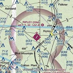
|
| Airport distance calculator |
|---|
|
|
| Sunrise and sunset |
|---|
|
Times for 18-Apr-2024
| | Local
(UTC-5) | | Zulu
(UTC) |
|---|
| Morning civil twilight | | 05:54 | | 10:54 |
| Sunrise | | 06:20 | | 11:20 |
| Sunset | | 19:30 | | 00:30 |
| Evening civil twilight | | 19:56 | | 00:56 |
|
| Current date and time |
|---|
| Zulu (UTC) | 18-Apr-2024 20:21:57 |
|---|
| Local (UTC-5) | 18-Apr-2024 15:21:57 |
|---|
|
| METAR |
|---|
KCRX
23nm NE | 181955Z AUTO 18009G15KT 160V230 10SM FEW024 SCT029 SCT120 26/21 A3000 RMK AO2
|
KM08
30nm N | 182000Z AUTO 16011G18KT 120V190 10SM FEW035 FEW110 27/20 A2996 RMK A01
|
KTUP
30nm SE | 181953Z 16008KT 10SM SCT024 SCT060 26/20 A3002 RMK AO2 SLP161 T02560200
|
KUOX
33nm SW | 181955Z AUTO 16008KT 130V200 10SM FEW023 FEW030 25/20 A3001 RMK AO2 PWINO TSNO
|
KSZY
38nm NE | 181955Z AUTO VRB06G16KT 10SM SCT024 SCT030 SCT043 26/19 A2999 RMK A01
|
KOLV
41nm NW | 181950Z 18012G20KT 10SM VCSH FEW034 SCT060 BKN070 26/20 A2995
|
|
| TAF |
|---|
KTUP
30nm SE | 181735Z 1818/1918 19006KT P6SM OVC015 FM182200 18009KT P6SM VCSH OVC100 PROB30 1822/1901 5SM -TSRA OVC035CB FM190200 17007KT P6SM OVC045 FM190600 17005KT P6SM OVC009 PROB30 1906/1910 5SM -TSRA OVC025CB FM191100 24006KT 4SM BR OVC009 FM191400 35009KT P6SM OVC015
|
|
| NOTAMs |
|---|
NOTAMs are issued by the DoD/FAA and will open in a separate window not controlled by AirNav.
|
|


