FAA INFORMATION EFFECTIVE 14 MAY 2026
Location
| FAA Identifier: | 28A |
| Lat/Long: | 35-07-15.5260N 080-35-14.2420W
35-07.258767N 080-35.237367W
35.1209794,-80.5872894
(estimated) |
| Elevation: | 565 ft. / 172 m (estimated) |
| Variation: | 05W (1985) |
| From city: | 6 miles NE of INDIAN TRAIL, NC |
| Time zone: | UTC -4 (UTC -5 during Standard Time) |
| Zip code: | 28079 |
Airport Operations
| Airport use: | Open to the public |
| Activation date: | 01/1970 |
| Control tower: | no |
| ARTCC: | ATLANTA CENTER |
| FSS: | RALEIGH FLIGHT SERVICE STATION |
| NOTAMs facility: | RDU (NOTAM-D service available) |
| Attendance: | IRREG |
| Pattern altitude: | 1100 ft. MSL
TPA: 535 FT AGL ULTRALIGHTS, 1035 FT AGL ALL OTR ACFT. |
| Wind indicator: | yes |
| Segmented circle: | no |
| Lights: | FM SS ON FOR 2 HRS. AFTER SS; FOR LGT AFTER HRS CALL 704-614-3084. |
Airport Communications
| CTAF/UNICOM: | 123.0 |
| WX ASOS at EQY (6 nm S): | 135.775 (704-283-5185) |
| WX AWOS-3 at JQF (17 nm N): | 133.675 (704-785-2145) |
| WX ASOS at CLT (19 nm W): | PHONE 704-255-5973 |
Nearby radio navigation aids
| VOR radial/distance | | VOR name | | Freq | | Var |
|---|
| CLTr108/18.4 | | CHARLOTTE VOR/DME | | 115.00 | | 05W |
| CTFr334/32.1 | | CHESTERFIELD VOR/DME | | 114.55 | | 03W |
| NDB name | | Hdg/Dist | | Freq | | Var | | ID |
|---|
| STONIA | | 105/28.3 | | 260 | | 06W | | GHJ | --. .... .--- |
Airport Services
| Parking: | tiedowns |
| Airframe service: | MAJOR
980-875-0114. |
| Powerplant service: | MAJOR |
| Bottled oxygen: | NONE |
| Bulk oxygen: | NONE |
Runway Information
Runway 4/22
| Dimensions: | 2350 x 35 ft. / 716 x 11 m |
| Surface: | asphalt, in fair condition |
| Runway edge lights: | non-standard
NSTD LIRL; NO THR LGTS. |
| RUNWAY 4 | | RUNWAY 22 |
| Traffic pattern: | left
R TFC FOR ULTRALIGHTS ONLY. | | left
R TFC FOR ULTRALIGHTS ONLY. |
| Displaced threshold: | 122 ft.
RWY 04 - NGT LDGS NOT AUTHORIZED. | | no |
| Markings: | basic, in fair condition | | basic, in fair condition |
| Obstructions: | 63 ft. trees, 353 ft. from runway, 124 ft. left of centerline, 2:1 slope to clear
8 FT HILL 80-160 FT FM THR OFFSET 90 FT LEFT OF CNTRLN; AND 10 FT GRAVEL PATH 0-200 FT FM THR OFFSET 30 FT RIGHT OF CNTRLN. | | 37 ft. trees, 253 ft. from runway, 3 ft. left of centerline, 1:1 slope to clear
41 FT TREES 150-200 FT FM THR OFFSET 110 FT RIGHT OF CNTRLN; 20 FT TREES 132 FT FM THR OFFSET 7 FT LEFT OF CNTRLN; AND 7 FT TRASH PILE 122 FT FM THR OFFSET 75 FT RIGHT OF CNTRLN. |
Airport Ownership and Management from official FAA records
| Ownership: | Privately-owned |
| Owner: | LOCO PANTHER AVIATION, LLC
2020 LAWYERS RD
INDIAN TRAIL, NC 28079
Phone 704-614-3084 |
| Manager: | SAM DONAHUE
2020 LAWYERS RD
INDIAN TRAIL, NC 28079
Phone 704-614-3084 |
Additional Remarks
| - | BIRDS AND WILDLIFE ON AND INVOF ARPT. |
| - | RWY 04/22 - FIRST 400 FT SW END UNLGTD. |
| - | RWY 04/22 HAS 15 FT DROP-OFF 50 FT FM CNTRLN ON SE SIDE AT MIDFIELD. |
| - | RWY 04/22 HAS 15 FT ROADS 55 FT FM CNTRLN BOTH SIDES OF RWY. |
| - | FARM EQPT ON AND INVOF ARPT. |
| - | USE CTN DUE TO EXTSV ULTRALIGHT ACT. |
| - | NO NGT LDGS 2 HRS AFTER SS. |
| - | FOR CD CTC CHARLOTTE APCH AT 704-359-0241. |
| - | CALL ARPT FOR FUEL WHEN UNATNDD 704-614-3084. |
| - | NMRS OBSTN (TREES, BLDGS, VEHICLES, PARKED ACFT & LANDSCAPE POLES) IN PRI SFC 65 FT FROM RWY CNTRLN. |
| - | NUMEROUS UNMARKED & UNLGTD OBSTN IN BOTH APPROACHES. |
Instrument Procedures
There are no published instrument procedures at 28A.
Some nearby airports with instrument procedures:
KEQY - Charlotte-Monroe Executive Airport (6 nm S)
KJQF - Concord-Padgett Regional Airport (17 nm N)
N52 - JAARS-Townsend Airport (17 nm SW)
KCLT - Charlotte/Douglas International Airport (19 nm W)
KUZA - Rock Hill (York County) Airport-Bryant Field (24 nm W)
|
|

Road maps at:
MapQuest
Bing
Google
| Aerial photo |
|---|
WARNING: Photo may not be current or correct

Do you have a better or more recent aerial photo of Goose Creek Airport that you would like to share? If so, please send us your photo.
|
| Sectional chart |
|---|
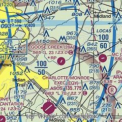
|
| Airport distance calculator |
|---|
|
|
| Sunrise and sunset |
|---|
|
Times for 07-Jun-2026
| | Local
(UTC-4) | | Zulu
(UTC) |
|---|
| Morning civil twilight | | 05:39 | | 09:39 |
| Sunrise | | 06:09 | | 10:09 |
| Sunset | | 20:34 | | 00:34 |
| Evening civil twilight | | 21:03 | | 01:03 |
|
| Current date and time |
|---|
| Zulu (UTC) | 07-Jun-2026 11:55:58 |
|---|
| Local (UTC-4) | 07-Jun-2026 07:55:58 |
|---|
|
| METAR |
|---|
KEQY
6nm S | 071053Z AUTO 23004KT 10SM CLR 18/17 A3002 RMK AO2 SLP166 T01830167
|
KJQF
17nm N | 071050Z 26006KT 10SM CLR 20/17 A3005
|
KCLT
19nm W | 071052Z 00000KT 9SM FEW180 SCT220 BKN250 20/17 A3003 RMK AO2 SLP174 T02000172 $
|
|
| TAF |
|---|
KCLT
19nm W | 070945Z 0710/0812 24004KT P6SM BKN250 FM071600 23007KT P6SM SCT060 BKN250 FM080300 24004KT P6SM BKN250
|
|
| NOTAMs |
|---|
NOTAMs are issued by the DoD/FAA and will open in a separate window not controlled by AirNav.
|
|

