FAA INFORMATION EFFECTIVE 18 APRIL 2024
Location
| FAA Identifier: | 2J9 |
| Lat/Long: | 30-35-52.3910N 084-33-26.7850W
30-35.873183N 084-33.446417W
30.5978864,-84.5574403
(estimated) |
| Elevation: | 221.2 ft. / 67.4 m (surveyed) |
| Variation: | 05W (2025) |
| From city: | 2 miles NE of QUINCY, FL |
| Time zone: | UTC -4 (UTC -5 during Standard Time) |
| Zip code: | 32351 |
Airport Operations
| Airport use: | Open to the public |
| Activation date: | 04/1940 |
| Control tower: | no |
| ARTCC: | JACKSONVILLE CENTER |
| FSS: | GAINESVILLE FLIGHT SERVICE STATION |
| NOTAMs facility: | GNV (NOTAM-D service available) |
| Attendance: | 0800-DUSK |
| Wind indicator: | lighted |
| Segmented circle: | yes |
| Lights: | ACTVT PAPI RWY 14 & 32; MIRL RWY 14/32 - CTAF. |
| Beacon: | white-green (lighted land airport)
Operates sunset to sunrise. |
Airport Communications
| CTAF/UNICOM: | 122.7 |
| WX AWOS-3PT: | 118.975 (850-627-6264) |
| TALLAHASSEE APPROACH: | 128.7 |
| TALLAHASSEE DEPARTURE: | 128.7 |
| WX ASOS at TLH (16 nm SE): | 119.45 (850-576-3665) |
- APCH/DEP SVC PRVDD BY JACKSONVILLE ARTCC ON FREQS 128.625/379.175 (TALLAHASSEE RCAG) WHEN TALLAHASSEE APCH CTL CLSD.
Nearby radio navigation aids
| VOR radial/distance | | VOR name | | Freq | | Var |
|---|
| SZWr283/9.8 | | SEMINOLE VORTAC | | 117.50 | | 02E |
| MAIr111/31.4 | | MARIANNA VORTAC | | 114.00 | | 00E |
| NDB name | | Hdg/Dist | | Freq | | Var | | ID |
|---|
| WILLIS | | 188/22.5 | | 359 | | 04W | | LYZ | .-.. -.-- --.. |
| CAIDY | | 234/26.9 | | 338 | | 04W | | CYR | -.-. -.-- .-. |
Airport Services
| Fuel available: | 100LL |
| Parking: | tiedowns |
| Airframe service: | MAJOR |
| Powerplant service: | MAJOR |
| Bottled oxygen: | NONE |
| Bulk oxygen: | NONE |
Runway Information
Runway 14/32
| Dimensions: | 2974 x 75 ft. / 906 x 23 m |
| Surface: | asphalt, in excellent condition |
| Weight bearing capacity: | | PCN 9 /F/A/Y/T | | Single wheel: | 20.0 |
|
| Runway edge lights: | medium intensity |
| RUNWAY 14 | | RUNWAY 32 |
| Latitude: | 30-36.048243N | | 30-35.698103N |
| Longitude: | 084-33.645017W | | 084-33.247817W |
| Elevation: | 221.1 ft. | | 203.4 ft. |
| Traffic pattern: | right | | left |
| Runway heading: | 141 magnetic, 136 true | | 321 magnetic, 316 true |
| Displaced threshold: | 267 ft. | | 322 ft. |
| Declared distances: | TORA:2964 TODA:2964 ASDA:2964 LDA:2700 | | TORA:2964 TODA:2964 ASDA:2755 LDA:2431 |
| Markings: | nonprecision, in good condition | | nonprecision, in good condition |
| Visual slope indicator: | 2-light PAPI on right (3.00 degrees glide path) | | 2-light PAPI on left (3.00 degrees glide path) |
| Touchdown point: | yes, no lights | | yes, no lights |
| Obstructions: | 70 ft. trees, 1605 ft. from runway, 160 ft. right of centerline, 20:1 slope to clear
RWY 32 APCH SLOPE 25:1 TO THE DTHR. | | 41 ft. trees, 925 ft. from runway, 110 ft. right of centerline, 17:1 slope to clear |
Airport Ownership and Management from official FAA records
| Ownership: | Publicly-owned |
| Owner: | QUINCY GADSDEN AIRPORT AUTHORITY
PO BOX 1905
QUINCY, FL 32353
Phone 850-627-2112
JANICE WATSON |
| Manager: | JANICE WATSON
1300 AIRPORT DR
QUINCY, FL 32352
Phone 850-643-7752 |
Airport Operational Statistics
| Aircraft based on the field: | | 72 | | Single engine airplanes: | | 68 | | Multi engine airplanes: | | 2 | | Gliders airplanes: | | 2 |
| |  | |
| Aircraft operations: avg 120/week * | | 65% | local general aviation | | 35% | transient general aviation | | * for 12-month period ending 05 March 2018 | |
Additional Remarks
| A30A-14 | APCH SLOPE 26:1 TO THE DSPLCD THR. |
| - | PAJA OPS; GLIDER OPS BLW 10000 FT ON & INVOF ARPT. |
| - | DEER INVOF MOVEMENT AREAS. |
| - | FOR CD CTC TALLAHASSEE APCH AT 850-942-8311, WHEN APCH CLSD CTC JACKSONVILLE ARTCC AT 904-845-1592. |
Instrument Procedures
NOTE: All procedures below are presented as PDF files. If you need a reader for these files, you should download the free Adobe Reader.NOT FOR NAVIGATION. Please procure official charts for flight.
FAA instrument procedures published for use from 18 April 2024 at 0901Z to 16 May 2024 at 0900Z.
IAPs - Instrument Approach Procedures |
|---|
| RNAV (GPS)-A | |
download (168KB) |
| NOTE: Special Alternate Minimums apply | |
download (124KB) |
| NOTE: Special Take-Off Minimums/Departure Procedures apply | |
download (162KB) |
Other nearby airports with instrument procedures:
KTLH - Tallahassee International Airport (16 nm SE)
KBGE - Decatur County Industrial Air Park (23 nm N)
70J - Cairo-Grady County Airport (27 nm NE)
17J - Donalsonville Municipal Airport (30 nm NW)
KMAI - Marianna Municipal Airport (35 nm NW)
|
|

Road maps at:
MapQuest
Bing
Google
| Aerial photo |
|---|
WARNING: Photo may not be current or correct
 Photo by Janice Watson
Photo taken 18-Oct-2021
looking north.
Photo by Janice Watson
Photo taken 18-Oct-2021
looking north.
Do you have a better or more recent aerial photo of Quincy Municipal Airport that you would like to share? If so, please send us your photo.
|
| Sectional chart |
|---|
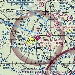
|
| Airport distance calculator |
|---|
|
|
| Sunrise and sunset |
|---|
|
Times for 24-Apr-2024
| | Local
(UTC-4) | | Zulu
(UTC) |
|---|
| Morning civil twilight | | 06:36 | | 10:36 |
| Sunrise | | 07:01 | | 11:01 |
| Sunset | | 20:11 | | 00:11 |
| Evening civil twilight | | 20:36 | | 00:36 |
|
| Current date and time |
|---|
| Zulu (UTC) | 24-Apr-2024 04:54:58 |
|---|
| Local (UTC-4) | 24-Apr-2024 00:54:58 |
|---|
|
| METAR |
|---|
| K2J9 | 240435Z AUTO 00000KT 7SM SCT003 SCT040 SCT049 11/09 A3016 RMK AO2
|
KTLH
16nm SE | 240353Z AUTO 00000KT 10SM CLR 12/08 A3015 RMK AO2 SLP208 T01170083
|
|
| TAF |
|---|
KTLH
16nm SE | 231731Z 2318/2418 18005KT P6SM SKC FM240300 VRB02KT P6SM SKC FM241600 21004KT P6SM SKC
|
|
| NOTAMs |
|---|
NOTAMs are issued by the DoD/FAA and will open in a separate window not controlled by AirNav.
|
|


