FAA INFORMATION EFFECTIVE 11 JUNE 2026
Location
| FAA Identifier: | 36K |
| Lat/Long: | 37-58-10.0000N 101-15-20.1000W
37-58.166667N 101-15.335000W
37.9694444,-101.2555833
(estimated) |
| Elevation: | 3076.4 ft. / 937.7 m (surveyed) |
| Variation: | 09E (1985) |
| From city: | 2 miles N of LAKIN, KS |
| Time zone: | UTC -5 (UTC -6 during Standard Time) |
| Zip code: | 67860 |
Airport Operations
| Airport use: | Open to the public |
| Activation date: | 06/1955 |
| Control tower: | no |
| ARTCC: | KANSAS CITY CENTER |
| FSS: | WICHITA FLIGHT SERVICE STATION |
| NOTAMs facility: | ICT (NOTAM-D service available) |
| Attendance: | MON-FRI 0800-1700 |
| Wind indicator: | lighted |
| Segmented circle: | no |
| Lights: | SS-SR |
| Beacon: | white-green (lighted land airport)
Operates sunset to sunrise. |
Airport Communications
| CTAF: | 122.9 |
| WX AWOS-3PT: | 118.225 (620-355-4004) |
Nearby radio navigation aids
| VOR radial/distance | | VOR name | | Freq | | Var |
|---|
| GCKr266/25.3 | | GARDEN CITY VORTAC | | 113.30 | | 11E |
Airport Services
| Fuel available: | 100LL |
| Parking: | hangars and tiedowns |
| Airframe service: | MAJOR |
| Powerplant service: | MAJOR |
| Bottled oxygen: | NONE |
| Bulk oxygen: | LOW |
Runway Information
Runway 14/32
| Dimensions: | 3410 x 40 ft. / 1039 x 12 m |
| Surface: | asphalt, in good condition |
| Weight bearing capacity: | |
| Runway edge lights: | medium intensity |
| RUNWAY 14 | | RUNWAY 32 |
| Latitude: | 37-58.396530N | | 37-57.895892N |
| Longitude: | 101-15.601693W | | 101-15.279667W |
| Elevation: | 3076.4 ft. | | 3053.9 ft. |
| Traffic pattern: | left | | left |
| Markings: | basic, in good condition | | basic, in good condition |
| Touchdown point: | yes, no lights | | yes, no lights |
| Obstructions: | road
10 FT RD 0 FT DSTC, 78 FT L ACRS APCH. | | 9 ft. road, 201 ft. from runway, 125 ft. left and right of centerline
9 FT RD, 193 FT DSTC, 125 L. |
Runway 2/20
| Dimensions: | 2579 x 90 ft. / 786 x 27 m |
| Surface: | turf, in poor condition
ROUGH & UNEVEN, BARE SPOTS, 6 FT. BERM BOTH SIDES OF RWY, MIDWAY. |
| RUNWAY 2 | | RUNWAY 20 |
| Latitude: | 37-58.017658N | | 37-58.367893N |
| Longitude: | 101-15.348462W | | 101-15.044587W |
| Elevation: | 3060.7 ft. | | 3051.3 ft. |
| Traffic pattern: | left | | left |
| Touchdown point: | yes, no lights | | yes, no lights |
| Obstructions: | none | | 32 ft. pline, 420 ft. from runway, 100 ft. left of centerline, 13:1 slope to clear |
Airport Ownership and Management from official FAA records
| Ownership: | Publicly-owned |
| Owner: | KEARNY COUNTY
304 N. MAIN ST., P.O. BOX 86
LAKIN, KS 67860
Phone 620-355-6422 |
| Manager: | KYMBERLY LOGAN
1662 RD. T
LAKIN, KS 67860
Phone 620-260-0502 |
Additional Remarks
| - | FOR CD CTC KANSAS CITY ARTCC AT 913-254-8508. |
Instrument Procedures
There are no published instrument procedures at 36K.
Some nearby airports with instrument procedures:
KULS - Ulysses Airport (23 nm S)
3K3 - Syracuse-Hamilton County Municipal Airport (23 nm W)
KGCK - Garden City Regional Airport (25 nm E)
3K7 - Mark Hoard Memorial Airport (30 nm N)
KJHN - Stanton County Municipal Airport (32 nm SW)
|
|

Road maps at:
MapQuest
Bing
Google
| Aerial photo |
|---|
WARNING: Photo may not be current or correct
 Photo taken 07-Sep-2007
Do you have a better or more recent aerial photo of Kearny County Airport that you would like to share? If so, please send us your photo.
|
| Sectional chart |
|---|
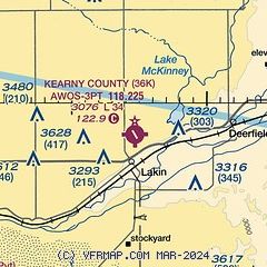
|
| Airport distance calculator |
|---|
|
|
| Sunrise and sunset |
|---|
|
Times for 30-Jun-2026
| | Local
(UTC-5) | | Zulu
(UTC) |
|---|
| Morning civil twilight | | 05:55 | | 10:55 |
| Sunrise | | 06:27 | | 11:27 |
| Sunset | | 21:11 | | 02:11 |
| Evening civil twilight | | 21:42 | | 02:42 |
|
| Current date and time |
|---|
| Zulu (UTC) | 30-Jun-2026 20:25:02 |
|---|
| Local (UTC-5) | 30-Jun-2026 15:25:02 |
|---|
|
| METAR |
|---|
KULS
23nm S | 301955Z AUTO 18017G22KT 10SM CLR 34/16 A2985 RMK AO2
|
K3K3
23nm W | 301955Z AUTO 18010KT 10SM CLR 34/15 A2986 RMK AO2
|
KGCK
26nm E | 301954Z 14017KT 7SM CLR 31/19 A2988 RMK AO2 PK WND 15033/1910 SLP075 T03060194
|
KJHN
32nm SW | 301955Z AUTO VRB04KT 10SM CLR 35/16 A2985 RMK AO2
|
KTQK
35nm NE | 301955Z AUTO 17015KT 10SM SCT055 32/19 A2988 RMK AO2 T03190193
|
|
| TAF |
|---|
KGCK
26nm E | 301737Z 3018/0118 18015G25KT P6SM BKN200 TEMPO 0100/0104 1SM TSRA BKN040CB FM010400 VRB06KT P6SM OVC200
|
|
| NOTAMs |
|---|
NOTAMs are issued by the DoD/FAA and will open in a separate window not controlled by AirNav.
|
|

