FAA INFORMATION EFFECTIVE 21 MARCH 2024
Location
| FAA Identifier: | 3D1 |
| Lat/Long: | 45-12-52.7071N 088-04-23.8734W
45-12.878452N 088-04.397890W
45.2146409,-88.0732982
(estimated) |
| Elevation: | 734.8 ft. / 224 m |
| Variation: | 02W (1985) |
| From city: | 3 miles SW of CRIVITZ, WI |
| Time zone: | UTC -5 (UTC -6 during Standard Time) |
| Zip code: | 54114 |
Airport Operations
| Airport use: | Open to the public |
| Activation date: | 04/1948 |
| Control tower: | no |
| ARTCC: | MINNEAPOLIS CENTER |
| FSS: | GREEN BAY FLIGHT SERVICE STATION |
| NOTAMs facility: | GRB (NOTAM-D service available) |
| Attendance: | UNATNDD |
| Wind indicator: | yes |
| Segmented circle: | yes |
| Lights: | ACTVT LIRL RWY 18/36 - 123.0. |
| Beacon: | white-green (lighted land airport)
ROTG BCN - 5 CLICKS ON 123.0. |
Airport Communications
| CTAF/UNICOM: | 122.8 |
| WX AWOS-3PT at MNM (19 nm E): | 121.45 (906-863-8801) |
Nearby radio navigation aids
| VOR radial/distance | | VOR name | | Freq | | Var |
|---|
| IMTr179/36.1 | | IRON MOUNTAIN VOR/DME | | 111.20 | | 02W |
| GRBr006/39.9 | | GREEN BAY VORTAC | | 115.50 | | 01E |
Airport Services
| Parking: | tiedowns |
| Airframe service: | NONE |
| Powerplant service: | NONE |
| Bottled oxygen: | NONE |
| Bulk oxygen: | NONE |
Runway Information
Runway 18/36
| Dimensions: | 2164 x 60 ft. / 660 x 18 m |
| Surface: | asphalt, in fair condition |
| Weight bearing capacity: | |
| Runway edge lights: | low intensity |
| Operational restrictions: | TO CONFIRM SNOW REMOVAL CTC AMGR. |
| RUNWAY 18 | | RUNWAY 36 |
| Latitude: | 45-13.036500N | | 45-12.680500N |
| Longitude: | 088-04.360667W | | 088-04.373500W |
| Elevation: | 729.8 ft. | | 730.2 ft. |
| Traffic pattern: | left | | left |
| Displaced threshold: | 115 ft. | | 101 ft. |
| Markings: | basic, in good condition | | basic, in good condition |
| Runway end identifier lights: | no | | no |
| Touchdown point: | yes, no lights | | yes, no lights |
| Obstructions: | 16 ft. road, 200 ft. from runway
3 FT BERM AT RWY END. | | 16 ft. road, 210 ft. from runway
3 FT BERM AT RWY END. |
Runway 9/27
| Dimensions: | 2545 x 80 ft. / 776 x 24 m |
| Surface: | turf, in fair condition |
| Runway edge markings: | MKD WITH YELLOW CONES. |
| Operational restrictions: | NOT PLOWED WINTER MONTHS. |
| RUNWAY 9 | | RUNWAY 27 |
| Latitude: | 45-12.901333N | | 45-12.889500N |
| Longitude: | 088-04.720333W | | 088-04.127833W |
| Elevation: | 734.8 ft. | | 728.4 ft. |
| Traffic pattern: | left | | left |
| Runway heading: | 094 magnetic, 092 true | | 274 magnetic, 272 true |
| Displaced threshold: | 595 ft. | | 138 ft. |
| Runway end identifier lights: | no | | no |
| Touchdown point: | yes, no lights | | yes, no lights |
| Obstructions: | 25 ft. pline, marked, 20 ft. from runway, 1:1 slope to clear
APCH RATIO 20:1 TO DSPLCD THR. | | 30 ft. trees, 50 ft. from runway, 100 ft. right of centerline, 1:1 slope to clear
APCH RATIO 6:1 TO DSPLCD THR; 30 FT TREES 188 FT FM DSPLCD THR, 100 FT R. |
Airport Ownership and Management from official FAA records
| Ownership: | Publicly-owned |
| Owner: | TOWN OF STEPHENSON
W9484 COUNTY ROAD X
CRIVITZ, WI 54114
Phone 715-854-2874 |
| Manager: | JIM STRADAL
W9484 COUNTY ROAD X
CRIVITZ, WI 54114
Phone (715) 927-2793 |
Airport Operational Statistics
| Aircraft operations: 200/year * | | 75% | local general aviation | | 25% | transient general aviation | | * for 12-month period ending 04 August 2023 | |
Additional Remarks
| - | DEER ON & INVOF ARPT. |
| - | FOR CD CTC MINNEAPOLIS ARTCC AT 651-463-5588. |
Instrument Procedures
There are no published instrument procedures at 3D1.
Some nearby airports with instrument procedures:
KMNM - Menominee Regional Airport (19 nm E)
KOCQ - Oconto/J Douglas Bake Municipal Airport (22 nm S)
KEZS - Shawano Municipal Airport (33 nm SW)
KSUE - Door County Cherryland Airport (35 nm SE)
KIMT - Ford Airport (36 nm N)
|
|

Road maps at:
MapQuest
Bing
Google
| Aerial photo |
|---|
WARNING: Photo may not be current or correct
 Taken mid October 2005
Do you have a better or more recent aerial photo of Crivitz Municipal Airport that you would like to share? If so, please send us your photo.
|
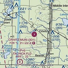
| Sectional chart |
|---|
|
| Airport distance calculator |
|---|
|
|
| Sunrise and sunset |
|---|
|
Times for 16-Apr-2024
| | Local
(UTC-5) | | Zulu
(UTC) |
|---|
| Morning civil twilight | | 05:34 | | 10:34 |
| Sunrise | | 06:05 | | 11:05 |
| Sunset | | 19:39 | | 00:39 |
| Evening civil twilight | | 20:10 | | 01:10 |
|
| Current date and time |
|---|
| Zulu (UTC) | 16-Apr-2024 08:50:26 |
|---|
| Local (UTC-5) | 16-Apr-2024 03:50:26 |
|---|
|
| METAR |
|---|
KMNM
20nm E | 160757Z AUTO 00000KT 10SM CLR 03/01 A3017 RMK AO2 SLP240 T00330006 $
|
KOCQ
22nm S | 160835Z AUTO 07003KT 10SM CLR 05/00 A3014 RMK AO1 T00540000
|
KEZS
33nm SW | 715-526-2967
160835Z AUTO 08008KT 10SM CLR 06/00 A3013 RMK AO2 T00641001
|
KSUE
35nm SE | 160756Z AUTO 10003KT 10SM CLR 06/00 A3017 RMK AO2 SLP217 T00560000
|
KIMT
36nm N | 160754Z AUTO 00000KT 10SM CLR M01/M03 A3015 RMK AO2 SLP218 T10061033
|
K3D2
38nm E | 160835Z AUTO 09003KT 10SM CLR 04/00 A3016 RMK AO2 T00371001
|
|
| TAF |
|---|
KGRB
44nm S | 160520Z 1606/1706 07010KT P6SM SCT150 FM161300 08011G17KT P6SM SCT180 FM162100 08018G25KT P6SM BKN080 FM162300 09019G28KT P6SM VCSH BKN060 FM170100 10021G31KT P6SM -SHRA OVC040 WS020/12050KT FM170300 11021G33KT P6SM -SHRA OVC023 WS020/12050KT FM170500 11021G33KT 6SM -SHRA OVC014 WS020/13055KT
|
|
| NOTAMs |
|---|
NOTAMs are issued by the DoD/FAA and will open in a separate window not controlled by AirNav.
|
|

