FAA INFORMATION EFFECTIVE 09 JULY 2026
Location
| FAA Identifier: | 46D |
| Lat/Long: | 47-27-04.0000N 099-09-04.8000W
47-27.066667N 099-09.080000W
47.4511111,-99.1513333
(estimated) |
| Elevation: | 1606.5 ft. / 489.7 m (surveyed) |
| Variation: | 07E (2000) |
| From city: | 1 mile W of CARRINGTON, ND |
| Time zone: | UTC -5 (UTC -6 during Standard Time) |
| Zip code: | 58421 |
Airport Operations
| Airport use: | Open to the public |
| Activation date: | 07/1945 |
| Control tower: | no |
| ARTCC: | MINNEAPOLIS CENTER |
| FSS: | GRAND FORKS FLIGHT SERVICE STATION |
| NOTAMs facility: | 46D (NOTAM-D service available) |
| Attendance: | UNATNDD |
| Wind indicator: | lighted |
| Segmented circle: | yes |
| Lights: | MIRL RY 13/31 OPER DUSK-0000, AFT 0000 ACTVT MIRL RY 13/31 & PAPI RYS 13 & 31 - CTAF. |
| Beacon: | white-green (lighted land airport)
Operates sunset to sunrise. |
Airport Communications
| CTAF: | 122.9 |
| WX AWOS-3: | 118.575 (701-652-1875) |
- APCH/DEP SVC PRVDD BY MINNEAPOLIS ARTCC ON FREQS 124.2/270.3 (WOODWORTH RCAG).
Nearby radio navigation aids
| VOR radial/distance | | VOR name | | Freq | | Var |
|---|
| JMSr324/36.6 | | JAMESTOWN VOR/DME | | 114.50 | | 04E |
Airport Services
| Fuel available: | 100LL
100LL:100LL 24HR SELF SERVICE CREDIT CARD. |
| Parking: | tiedowns |
| Airframe service: | NONE |
| Powerplant service: | NONE |
| Bottled oxygen: | NONE |
| Bulk oxygen: | NONE |
Runway Information
Runway 13/31
| Dimensions: | 4198 x 75 ft. / 1280 x 23 m |
| Surface: | asphalt, in good condition |
| Runway edge lights: | medium intensity |
| RUNWAY 13 | | RUNWAY 31 |
| Latitude: | 47-27.330842N | | 47-26.802128N |
| Longitude: | 099-09.407885W | | 099-08.753053W |
| Elevation: | 1606.3 ft. | | 1605.8 ft. |
| Traffic pattern: | left | | left |
| Runway heading: | 133 magnetic, 140 true | | 313 magnetic, 320 true |
| Markings: | nonprecision, in good condition | | nonprecision, in good condition |
| Visual slope indicator: | 2-light PAPI on left (3.00 degrees glide path) | | 2-light PAPI on left (3.00 degrees glide path) |
| Touchdown point: | yes, no lights | | yes, no lights |
Airport Ownership and Management from official FAA records
| Ownership: | Publicly-owned |
| Owner: | CARRINGTON ARPT AUTHORITY
P.O. BOX 314
CARRINGTON, ND 58421
Phone (701) 652-2911
JENNIFER GAST, ARPT AUTH CLERK, 701-652-2911, EXT 3. |
| Manager: | JASON WOLSKY
103 10TH AVE N, PO BOX 139
CARRINGTON, ND 58421
Phone (701) 652-5206
AMGR'S TEL 701-652-5206. |
Additional Remarks
| - | FOR SNOW REMOVAL INFO CTC AMGR 701-652-5206. |
| - | RWY 13 HAS - 6 FT DITCH 120 FT L OF EXTDD CNTRLN, 70' OUTBOUND FM THR. |
| - | FOR CD CTC MINNEAPOLIS ARTCC AT 651-463-5588. |
| - | BIRDS & DEER INVOF ARPT. |
Instrument Procedures
NOTE: All procedures below are presented as PDF files. If you need a reader for these files, you should download the free Adobe Reader.NOT FOR NAVIGATION. Please procure official charts for flight.
FAA instrument procedures published for use from 09 July 2026 at 0901Z to 06 August 2026 at 0900Z.
IAPs - Instrument Approach Procedures |
|---|
| RNAV (GPS) RWY 31 | |
download (238KB) |
| NOTE: Special Alternate Minimums apply | |
download (81KB) |
| NOTE: Special Take-Off Minimums/Departure Procedures apply | |
download (157KB) |
Other nearby airports with instrument procedures:
KJMS - Jamestown Regional Airport (37 nm SE)
5H4 - Harvey Municipal Airport (38 nm NW)
KDVL - Devils Lake Regional Airport (41 nm N)
S32 - Cooperstown Municipal Airport (42 nm E)
5L0 - Lakota Municipal Airport (48 nm NE)
|
|

Road maps at:
MapQuest
Bing
Google
| Aerial photo |
|---|
WARNING: Photo may not be current or correct

Do you have a better or more recent aerial photo of Carrington Municipal Airport that you would like to share? If so, please send us your photo.
|
| Sectional chart |
|---|
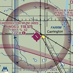
|
| Airport distance calculator |
|---|
|
|
| Sunrise and sunset |
|---|
|
Times for 20-Jul-2026
| | Local
(UTC-5) | | Zulu
(UTC) |
|---|
| Morning civil twilight | | 05:23 | | 10:23 |
| Sunrise | | 06:01 | | 11:01 |
| Sunset | | 21:25 | | 02:25 |
| Evening civil twilight | | 22:02 | | 03:02 |
|
| Current date and time |
|---|
| Zulu (UTC) | 20-Jul-2026 20:58:54 |
|---|
| Local (UTC-5) | 20-Jul-2026 15:58:54 |
|---|
|
| METAR |
|---|
| K46D | 202055Z AUTO 31022G31KT 10SM SCT050 SCT055 28/17 A2982 RMK AO2
|
|
| TAF |
|---|
KJMS
37nm SE | 201728Z 2018/2118 31020G30KT P6SM SCT200 FM210100 33021G32KT P6SM FEW060 FEW250 FM211100 34013G22KT P6SM FEW029 SCT220
|
KDVL
41nm N | 201916Z 2019/2118 31020G26KT P6SM SCT040 FM202300 32022G28KT P6SM VCSH BKN100 FM210300 35018G26KT P6SM BKN100 FM210700 33013KT P6SM OVC250
|
|
| NOTAMs |
|---|
NOTAMs are issued by the DoD/FAA and will open in a separate window not controlled by AirNav.
|
|

