FAA INFORMATION EFFECTIVE 16 APRIL 2026
Location
| FAA Identifier: | 49B |
| Lat/Long: | 44-25-07.2371N 103-22-39.8062W
44-25.120618N 103-22.663437W
44.4186770,-103.3777239
(estimated) |
| Elevation: | 3254.9 ft. / 992 m (estimated) |
| Variation: | 11E (1995) |
| From city: | 4 miles E of STURGIS, SD |
| Time zone: | UTC -6 (UTC -7 during Standard Time) |
| Zip code: | 57785 |
Airport Operations
| Airport use: | Open to the public |
| Activation date: | 04/1994 |
| Control tower: | no |
| ARTCC: | DENVER CENTER |
| FSS: | HURON FLIGHT SERVICE STATION |
| NOTAMs facility: | HON (NOTAM-D service available) |
| Attendance: | DAYLIGHT HOURS
FOR ATTENDANT OTR HRS CALL 605-347-3356. |
| Wind indicator: | lighted |
| Segmented circle: | no |
| Lights: | ACTVT MIRL RWY 11/29; PAPI RWY 11 & 29 - CTAF. |
| Beacon: | white-green (lighted land airport)
Operates sunset to sunrise. |
Airport Communications
| CTAF/UNICOM: | 122.8 |
| WX AWOS-3P: | 119.275 (605-347-3356) |
| ELLSWORTH APPROACH: | 119.5 [0500-0000] |
| ELLSWORTH DEPARTURE: | 119.5 [0500-0000] |
| WX AWOS-3 at SPF (18 nm W): | 118.325 (605-642-8536) |
- AUTOMATED UNICOM.
- APCH/DEP CTL SVC PRVDD BY DENVER ARTCC (ZDV) ON FREQS 127.95/338.2 (RAPID CITY RCAG) WHEN ELLSWORTH APCH CTL (RCA) CLSD.
Nearby radio navigation aids
| VOR radial/distance | | VOR name | | Freq | | Var |
|---|
| RAPr316/30.9 | | RAPID CITY VORTAC | | 112.30 | | 13E |
Airport Services
| Fuel available: | 100LL JET-A
100LL:FUEL AVBL 24 HRS WITH CREDIT CARD. |
| Parking: | hangars and tiedowns |
| Airframe service: | MAJOR |
| Powerplant service: | MAJOR |
Runway Information
Runway 11/29
| Dimensions: | 5100 x 75 ft. / 1554 x 23 m |
| Surface: | concrete, in excellent condition |
| Weight bearing capacity: | |
| Runway edge lights: | medium intensity |
| RUNWAY 11 | | RUNWAY 29 |
| Latitude: | 44-25.306692N | | 44-24.856327N |
| Longitude: | 103-23.021197W | | 103-22.033108W |
| Elevation: | 3244.1 ft. | | 3207.8 ft. |
| Traffic pattern: | left | | left |
| Runway heading: | 112 magnetic, 123 true | | 292 magnetic, 303 true |
| Markings: | nonprecision, in good condition | | nonprecision, in good condition |
| Visual slope indicator: | 2-light PAPI on left (3.00 degrees glide path) | | 2-light PAPI on left (3.00 degrees glide path) |
| Touchdown point: | yes, no lights | | yes, no lights |
Runway 5/23
| Dimensions: | 3580 x 120 ft. / 1091 x 37 m |
| Surface: | turf, in good condition |
| RUNWAY 5 | | RUNWAY 23 |
| Latitude: | 44-25.031500N | | 44-25.321167N |
| Longitude: | 103-23.215500W | | 103-22.499667W |
| Elevation: | 3254.9 ft. | | 3225.0 ft. |
| Traffic pattern: | left | | left |
| Runway heading: | 050 magnetic, 061 true | | 230 magnetic, 241 true |
| Touchdown point: | yes, no lights | | yes, no lights |
| Obstructions: | 41 ft. hill, 1099 ft. from runway, 26:1 slope to clear | | none |
Airport Ownership and Management from official FAA records
| Ownership: | Publicly-owned |
| Owner: | CITY OF STURGIS
1040 SECOND ST STE. 103
STURGIS, SD 57785
Phone 605-347-4422 |
| Manager: | ROGER BURNHAM
13345 ALKALI RD
STURGIS, SD 57785
Phone 605-720-9938 |
Additional Remarks
| - | WILDLIFE ON AND INVOF ARPT. |
| - | GCO AVBL ON FREQ 121.725 (4 CLICKS TO ELLSWORTH APPROACH AND 6 CLICKS TO DENVER CENTER) |
| - | FOR CD IF UNA VIA GCO CTC DENVER ARTCC AT 303-651-4257. |
| - | HIGH VOL OF ACFT OPRNG INVOF OF MT RUSHMORE AND CRAZY HORSE MONUMENTS AT OR BLW 7500 FT; PILOTS ARE ADVISED TO MNT 122.85 FOR TFC ADVISORIES. |
Instrument Procedures
NOTE: All procedures below are presented as PDF files. If you need a reader for these files, you should download the free Adobe Reader.NOT FOR NAVIGATION. Please procure official charts for flight.
FAA instrument procedures published for use from 16 April 2026 at 0901Z to 14 May 2026 at 0900Z.
IAPs - Instrument Approach Procedures |
|---|
| RNAV (GPS) RWY 11 | |
download (210KB) |
| RNAV (GPS) RWY 29 | |
download (214KB) |
| NOTE: Special Alternate Minimums apply | |
download (175KB) |
| NOTE: Special Take-Off Minimums/Departure Procedures apply | |
download (229KB) |
Other nearby airports with instrument procedures:
KSPF - Black Hills Airport-Clyde Ice Field (18 nm W)
KRCA - Ellsworth Air Force Base (20 nm SE)
KRAP - Rapid City Regional Airport (26 nm SE)
KEFC - Belle Fourche Municipal Airport (28 nm NW)
KECS - Mondell Field Airport (52 nm SW)
|
|

Road maps at:
MapQuest
Bing
Google
| Aerial photo |
|---|
WARNING: Photo may not be current or correct
 Photo by Andreas Lauschke
Photo taken 13-Sep-2024
from South looking North.
Photo by Andreas Lauschke
Photo taken 13-Sep-2024
from South looking North.
Do you have a better or more recent aerial photo of Sturgis Municipal Airport that you would like to share? If so, please send us your photo.
|
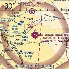
| Sectional chart |
|---|
|
| Airport distance calculator |
|---|
|
|
| Sunrise and sunset |
|---|
|
Times for 11-May-2026
| | Local
(UTC-6) | | Zulu
(UTC) |
|---|
| Morning civil twilight | | 04:58 | | 10:58 |
| Sunrise | | 05:32 | | 11:32 |
| Sunset | | 20:08 | | 02:08 |
| Evening civil twilight | | 20:41 | | 02:41 |
|
| Current date and time |
|---|
| Zulu (UTC) | 11-May-2026 13:08:52 |
|---|
| Local (UTC-6) | 11-May-2026 07:08:52 |
|---|
|
| METAR |
|---|
KSPF
17nm W | 111255Z AUTO 11003KT 10SM CLR 14/04 A2999 RMK AO2
|
|
| TAF |
|---|
KRCA
21nm SE | 111100Z 1111/1217 VRB06KT 9999 FEW100 QNH2995INS BECMG 1118/1119 33015G30KT 9999 FEW100 510002 QNH2980INS BECMG 1202/1203 33010G20KT 9999 SCT080 QNH2987INS TX33/1122Z TN08/1111Z
|
KRAP
26nm SE | 111124Z 1112/1212 VRB05KT P6SM SCT150 FM111600 18010G18KT P6SM SCT150 FM112000 34015G30KT P6SM FEW090 SCT150 FM120700 33010KT P6SM SKC
|
|
| NOTAMs |
|---|
NOTAMs are issued by the DoD/FAA and will open in a separate window not controlled by AirNav.
|
|

